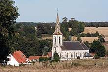
Airon-Saint-Vaast
| Airon-Saint-Vaast | ||
|---|---|---|

|
|
|
| region | Hauts-de-France | |
| Department | Pas-de-Calais | |
| Arrondissement | Montreuil | |
| Canton | Berck | |
| Community association | Deux Baies en Montreuillois | |
| Coordinates | 50 ° 26 ′ N , 1 ° 40 ′ E | |
| height | 4–52 m | |
| surface | 5.92 km 2 | |
| Residents | 186 (January 1, 2017) | |
| Population density | 31 inhabitants / km 2 | |
| Post Code | 62180 | |
| INSEE code | 62016 | |
Airon-Saint-Vaast is a commune with 186 inhabitants (as of January 1 2017) in the department of Pas-de-Calais in the region of Hauts-de-France . Airon-Saint-Vaast is part of the arrondissement of Montreuil and the canton of Berck . The inhabitants are called Aironnois .
geography
Airon-Saint-Vaast is located in the Marquenterre countryside near the Opal Coast . Airon-Saint-Vaast is surrounded by the neighboring communities Airon-Notre-Dame in the north, Campigneulles-les-Grandes in the east and northeast, Wailly-Beaucamp in the southeast and Rang-du-Fliers in the south and west.
The A16 autoroute runs through the east of the municipality .
Population development
| year | 1962 | 1968 | 1975 | 1982 | 1990 | 1999 | 2006 | 2013 |
|---|---|---|---|---|---|---|---|---|
| Residents | 171 | 144 | 130 | 120 | 166 | 231 | 223 | 194 |
| Source: Cassini and INSEE | ||||||||
Attractions
- Saint-Vaast church from 1877
- Bavemont chapel from 1809
- Airon-Saint-Vaast castle from the 19th century, monument historique since 1984
Web links
Commons : Airon-Saint-Vaast - Collection of images, videos and audio files

