Cerdanya (Comarca)
| Cerdanya | |
|---|---|

|
|
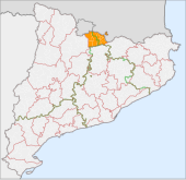
| The location of the Comarca of Cerdanya in Catalonia | |
| Basic data | |
| Provinces: | Girona , Lleida |
| Main place: | Puigcerdà |
| Surface: | 546.57 km² |
| Residents: | 18,192 (2019) |
| Municipalities: | 17th |
The comarca of Cerdanya is in the province of Girona of the Autonomous Community of Catalonia ( Spain ). The community association has an area of 547 km² and 18,192 inhabitants (2019).
General
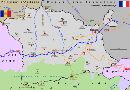
To distinguish the Comarca Alta Cerdanya ( Upper Cerdanya ) in Northern Catalonia in the southwest of France , the Spanish Comarca is also called Baixa Cerdanya ( Lower Cerdanya ).
The name of Sardana , the Catalan national dance , is derived with high probability from the Catalan adjective cerdana ( coming from Cerdanya ) .
To the east of the capital Puigcerdà in France is the Spanish exclave Llívia .
location
The community association is located in the northeastern part of Catalonia, it borders in the southeast on the comarca Ripollès , in the south on Berguedà , in the west on Alt Urgell, in the north on the Principality of Andorra and in the east on the comarca Alta Cerdanya of the Republic of France . Together with the comarcas Alta Ribagorça , Alt Urgell, Pallars Jussà , Pallars Sobirà and Vall d'Aran , the region forms the territory of Alt Pirineu i Aran . Barcelona is about 150 km to the south-east.
Coming from France, the upper reaches of the Segre River flows through the district in an east-west direction. On the northern side of the valley runs the high mountain region of the Pyrenees with the Puigpedrós (2,911 m) and the highest mountain Cerdanyas, the Tossa Plana de Lles (2,916 m). On the southern side are the Pre-Pyrenees with the Serra del Cadí , Serra de Moixeró and Serra Tosa d'Alp mountain ranges . These mountain ranges form the Parc Natural del Cadí-Moixeró, founded in 1983 . The highest peaks are the Pic de Costa Cabirolera (2,604 m) and the Comabona (2,547 m).
history
On November 7, 1659, in the Pyrenees Treaty between the French King Louis XIV and the Spanish King Philip IV, Catalonia was divided. The French part became Roussillon , the Spanish part Catalunya . Cerdanya was divided into two halves, the Spanish Baixa Cerdanya and the French Alta Cerdanya . The municipality of Llívia remained with Spain and forms a Spanish exclave on French territory. The capital, Puigcerdà, is connected to Llívia by a “neutral” road.
In 1833, provinces were formed in Spain. The administration of the municipalities of Cerdanyas was divided between the province of Lleida (six municipalities) and the province of Girona (eight municipalities).
Attractions
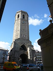
The numerous Romanesque church buildings are of cultural and historical interest.
economy
Agriculture and forestry have lost their importance. For this, jobs have been created in the textile, construction and wood industries. Tourism and the related service sector is an important source of income in the region. The comarca is a popular winter sports region, with designated ski areas at Aránser, Guils, LLes, Masella and La Molina.
Communities
Status: 2019
| local community | Residents | Area (km²) |
province | local community | Residents | Area (km²) |
province | |
|---|---|---|---|---|---|---|---|---|
| Alp | 1580 | 44.06 | Girona | Llívia | 1417 | 12.83 | Girona | |
| Bellver de Cerdanya | 1937 | 97.79 | Lleida | Meranges | 104 | 37.58 | Girona | |
| Bolvir | 369 | 10.66 | Girona | Montellà i Martinet | 579 | 55.08 | Lleida | |
| The | 253 | 14.83 | Girona | Prats i Sansor | 219 | 6.21 | Lleida | |
| Fontanals de Cerdanya | 444 | 28.68 | Girona | Prullans | 231 | 21.19 | Lleida | |
| Ger | 448 | 32.70 | Girona | Puigcerdà | 9258 | 18.62 | Girona | |
| Guils de Cerdanya | 537 | 22.26 | Girona | Riu de Cerdanya | 93 | 12.35 | Lleida | |
| Isòvol | 281 | 10.80 | Girona | Urus | 189 | 17.57 | Girona | |
| Lles de Cerdanya | 253 | 102.98 | Lleida |
See also
Web links
- Association of municipalities (Catalan, Spanish, English, German, French)
- Turisme (Spanish, English, French)
- gencat-Turisme (Catalan, Spanish, English, German, French)
- Attractions
- The Cerdanya (Spanish)


