
Crans-Montana
| Crans-Montana | |
|---|---|
 |
|
| State : |
|
| Canton : |
|
| District : | Sierre |
| BFS no. : | 6253 |
| Postal code : | 3963 Crans-Montana 3971 Chermignon 3974 Mollens 3975 Randogne |
| Coordinates : | 603400 / 128 950 |
| Height : | 1495 m above sea level M. |
| Height range : | 533-3175 m above sea level M. |
| Area : | 59.66 km² |
| Residents: | 10,449 (December 31, 2018) |
| Population density : | 175 inhabitants per km² |
| Website: | www.commune-cransmontana.ch |
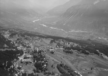
 Crans-Montana in July 2020 |
|
| Location of the municipality | |
  |
|
Crans-Montana is a municipality in the French-speaking part of the Swiss canton of Valais ( Sierre district ), which was created on January 1, 2017 from the merger of the former municipalities of Chermignon , Mollens (VS) , Montana and Randogne . It also forms a parish of the Deanery of Sierre .
Tourist origins
The holiday region of Crans-Montana originally became known as a tourist center on the high plateau around the municipality of Montana , which has grown together with the Crans-sur-Sierre holiday complex , which was created in 1929 , and which has become known in tourist parlance under this double name.
The Crans-Montana holiday area also includes the two municipalities of Icogne and Lens , the villages of Chermignon , Mollens and Randogne as well as a number of smaller settlements on the slope high above the Rhone valley between Sion and Sierre .
The establishment of the place Crans-Montana took place in 1892 with the opening of the Hôtel du Parc by Messrs Antille and Zufferey from Sierre. The real founder, however, is Theodor Stephani , who in 1897 brought his patients to this plateau, which is adorned by small lakes and extensive spruce forests, and in 1899 opened the Beauregard sanatorium.
Access
Both from Sion and from Sierre, winding access roads lead from Autobahn 9, which runs through the Rhône Valley . A height difference of 1000 meters is overcome over a distance of 13 kilometers. The ascent through the vineyards and alpine meadows takes around 35 minutes from Sion and around 20 minutes from Sierre.
The place can also be reached from Sierre by funicular , and from Sion by bus. The Sierre-Montana-Crans funicular railway operated by the Chemin de Fer et d'Autobus Sierre-Montana-Crans (SMC) was built with two sections due to its great length and opened in 1911. During the renovation in 1997, the two sections were connected to avoid having to change trains at the St-Maurice-de-Laques middle station . Since then, the system has been one of the longest funiculars in Europe with a length of 4191 meters and a difference in altitude of 927 meters.
There are also numerous bicycle and hiking trails between the individual hillside settlements.
politics
In the 2019 Swiss parliamentary elections, the share of the vote in Crans-Montana was: CVP 26.1%, FDP 21.4%, SVP 20.7%, SP 16.4%, Greens 13.0%.
Tourism and sport
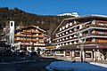
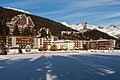
Narrow streets with hotels and apartments, cafes and restaurants, shops and administrative facilities characterize the center of Crans-sur-Sierre and Montana. There is a high volume of traffic in the main season. There are several ponds with green spaces on the outskirts.
Crans-Montana has become known through numerous events in alpine skiing . The Alpine World Ski Championships were held here in 1987 . There are a total of 160 kilometers of ski slopes. Summer skiing is possible on the southern edge of the Plaine Morte Glacier .
In summer, Crans-Montana is a center of golf . The Crans-sur-Sierre Golf Club, which has two golf courses (9 and 18 holes) , organizes the Omega European Masters here every year , one of the most famous golf tournaments in Europe.
In the late 1960s, a hill climb was held on the road from Sierre to Crans-Montana , which was also part of the European Hill Climb Championship . Crans-Montana was the venue for the 2008 Mountain Running World Championships .
Gondola lifts and cable cars as well as a 135 km long network of trails for hikers and mountain bikers open up the glaciers, rock groups, mountain lakes, Alps, meadows and coniferous forests on the southern edge of the Bernese Alps north of the mountain terrace of Crans-Montana . The Crans – Cry d'Er gondola went into operation in 1950. It was one of the world's first railways based on the Bell / Wallmannsberger system . The linguistic border between French and German-speaking Switzerland and at the same time the border with the canton of Bern runs on the ridges at an altitude of approx. 3000 m past Wildstrubel , along the Plaine-Morte Glacier, Weisshorn , Mittaghorn , Rohrbachstein and Wetzsteinhorn . The Lac de Tseuzier ( 1777 m above sea level ) is also integrated into this network of trails .
From the vantage point below Bella Lui ( 2548 m above sea level ) the glaciers of the Valais Alps south of the Rhône can be seen on a spectrum from the Mischabel group in the east to the peaks in the lower Valais in the west, including the Matterhorn and Mont Blanc .
Climate table
| Crans-Montana, 1981-2010 | ||||||||||||||||||||||||||||||||||||||||||||||||
|---|---|---|---|---|---|---|---|---|---|---|---|---|---|---|---|---|---|---|---|---|---|---|---|---|---|---|---|---|---|---|---|---|---|---|---|---|---|---|---|---|---|---|---|---|---|---|---|---|
| Climate diagram | ||||||||||||||||||||||||||||||||||||||||||||||||
| ||||||||||||||||||||||||||||||||||||||||||||||||
|
Average monthly temperatures and rainfall for Crans-Montana, 1981–2010
Source:
|
||||||||||||||||||||||||||||||||||||||||||||||||||||||||||||||||||||||||||||||||||||||||||||||||||||||||||||||||||||||||||||||||||||||||||||||||||||||||||||||||||||||||||||||||||||
Attractions
photos
Village center
Etang Grenon

Hotel Ambassador
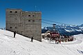
Mountain station and restaurant Bella Lui

Funicular, view from Sierre

Etang Grenon in summer 2020
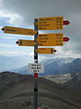
The signpost at the pass crossing on the Plaine Morte at an altitude of 2927 m . The top of the mountain is 2993 m above sea level. M. high


Personalities
- Susanne Ruoff (* 1958), manager, lives in Crans-Montana
- Roger Moore (1927–2017), actor, lived in Crans-Montana and Monaco
literature
- Editor: Crans-Montana. In: Historical Lexicon of Switzerland . 2017 .
- Hugues Rey: Montana. In: Historical Lexicon of Switzerland . 2017 .
- Danielle Allet-Zwissig: Chermignon. In: Historical Lexicon of Switzerland . 2017 .
- Hugues Rey: Mollens (VS). In: Historical Lexicon of Switzerland . 2017 .
- Bernard Truffer: Randogne. In: Historical Lexicon of Switzerland . 2017 .
Web links
Individual evidence
- ↑ Permanent and non-permanent resident population by year, canton, district, municipality, population type and gender (permanent resident population). In: bfs. admin.ch . Federal Statistical Office (FSO), August 31, 2019, accessed on December 22, 2019 .
- ^ Funiculaire. In: Website of the Compagnie de Chemin de Fer et d'Autobus Sierre-Montana-Crans (SMC). 2017, accessed June 1, 2017 (French).
- ^ Federal Statistical Office : NR - Results parties (municipalities) (INT1). In: Federal Elections 2019 | opendata.swiss. August 8, 2019, accessed August 1, 2020 .
- ↑ Climate table. In: meteoschweiz.admin.ch. meteoschweiz, accessed on December 6, 2018 .
Anniviers | Chalais | Chippis | Crans-Montana | Grône | Icogne | Lens | Miège | Saint-Léonard | Sierre | Venthône | Veyras
Former municipalities: Ayer (Val d'Anniviers) | Chandolin | Chermignon | Granges | Grimentz | Mollens | Montana | Randogne | Saint-Jean | Saint-Luc | Vissoie
Canton of Valais | Districts of the canton of Valais | Municipalities of the canton of Valais