
Boys (St. Niklaus)
| Boys | ||
|---|---|---|
| State : |
|
|
| Canton : |
|
|
| District : | Visp | |
| Municipal municipality : | St. Niklaus VS | |
| Postal code : | 3924 | |
| Coordinates : | 627 810 / 116054 | |
| Height : | 1960 m above sea level M. | |
| Website: | www.st-niklaus.ch | |
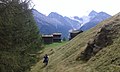
 View from Jungtal ( 2387 m above sea level ) to the Junge settlement ( 1960 m above sea level ) |
||
| map | ||
|
||

Junge ( Valais German Jungu ) is a hamlet or an alp of the municipality of St. Niklaus (Valais German Zaniglas ) in the Valais district of Visp .
geography

Junge lies on several rock humps above a rock face that drops steeply into the Nikolaital east of the Jungtal ( 2387 m above sea level ) with the Jungbach flowing down from the Jungtaljoch ( 3220 m above sea level ) and the Junggletscher ( 2993 m above sea level ) .
The Junge settlement is located at 1960 m above sea level. M. on the left flank of the valley above St. Niklaus Dorf ( 1120 m above sea level , Valais German Zaniglas ) and can be reached on foot by land via the Jungeweg . On the southern border of the settlement, on a rock ledge, is the Junge chapel at an altitude of 1940 m above sea level. M.
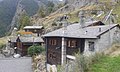
The smaller settlement Wintergadmen ( Valais German Wintergadmu ) at 1809 m is also a part of the boys . Individual buildings and groups of buildings are scattered between the two settlements on the two slopes of the Chelchuzigji rift.
- Right slope Chelchuzigji:
- Left slope Chelchuzigji:
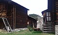
The buildings are log houses made of larch wood with roofs made of solid stone slabs .
From Junge, you can see up to fourteen four-thousand-meter peaks and, with good visibility, even the Aletsch Glacier .
"Open-air museums" Junge, Egga, Biel, Lerchji and Wintergadmen
The following impressions were taken on Sunday, September 4th, 2016, during a walk from the Jungs chapel to Jungeralp and on to Egga, Biel, Lerchji and Wintergadmen.
Settlement boys


Egga, Biel, Lerchji and Wintergadmen

Egga at 1934 m above sea level M. , in the background Waar, Staldenried , Bärgji, Hannigalp and Grächen

Biel at 1895 m above sea level M.

Biel at 1895 m above sea level M.
Lerchji at 1798 m above sea level. M. , in the background Ried Glacier and Nadelgrat
Lerchji at 1798 m above sea level. M. , in the background Waar

Lerchji at 1798 m above sea level. M. , in the background Hannigalp, Grächen and Niedergrächen

Wintergadmen at 1809 m , in the background Castor, Pollux, Breithorn, Klein Matterhorn, Mettelhorn, Brunegghorn and the flank of the Weisshorn

Wintergadmen at 1809 m above sea level. M. , on the left the Riedbach , on the right the Nikolaital
Wintergadmen at 1809 m above sea level. M.


history
Animal bones found during the renovation of the boys' chapel in the 1950s suggest that boys were already settled in the Mesolithic . The chapel, which still exists today and is consecrated to Mary, was built in 1762 at 1940 m above sea level. M. rebuilt.
Until the onset of the Little Ice Age at the beginning of the 15th century, Jungs was a year-round inhabited settlement and an independent municipality.
Surname boys
The surname Junge comes from the hamlet or Alp Jungs in the municipality of St. Niklaus VS. In 1304 Johann, son of Walter from the boy, is mentioned in a document. Walter from boys had Zehndenrechte by the family of Underfluh, residing at Stalden . Johann Jungs lived near Burgen in Törbel in 1334 . In 1400 Anton Junge lived in Stalden and his father Johann lived in Embd . A branch of the Junge family moved to Sion in 1400 , where in 1445 Arnold Junge became district messenger for Sion and in 1447 mayor of Sion. Another branch of the Junge family settled in Frutigen in the 16th century .
Seewjinen rest area and Alpine Festival

Since 1980, the Alpine Festival has been held on boys every year towards the end of July or the beginning of August, which opens with a field service at the Seewjinen rest area ( Valaisian Seewjini ) at 1998 m , which is not far above the terminus of the St. Niklaus Dorf - Boy is located. At this rest area there is a small lake, fire pits and wooden tables with benches.
_VS.jpg)
Jungeralp and Jungtalalp
The Jungeralp alpine hut is located on the northern border of the Junge settlement at an altitude of 1989 m above sea level. M. , which uses 140 hectares of pasture land . The grazing rights are tied to the private property of boys. So it is a Güteralp. In addition, there is also the Junge Bergschaft, which owns the buildings and the forest. The management takes place on a cooperative basis. The cooperative is headed by an Alpine Bailiff. Every year at the beginning of summer in June, the alpine pasture takes place with a mass celebration in the boys chapel. In high summer in August, the alpine hut in the Jungtal at an altitude of 2387 m and its pastureland is used.
Junge is one of the Alps in the canton of Valais, whose natural cheese is “1A” quality and therefore has the “Raclette du Valais AOP” brand or the name “Junge” embossed or as a relief on the side of the cheese (the “cylinder wall”, so to speak) of the loaf can carry.
Jungeralp-Liädji
The Jungeralp-Liädji, also known as Jungeliädji ( Liädji Valais German for song ), was composed and written by Karl Burgener , who was pastor in St. Niklaus from 1965 to 1993.
Jungeralp passenger cable car (Jungerbahn)


A passenger cable car leads from St. Niklaus Dorf to the settlement at 1990.5 m above sea level. M. , whose valley station ( 1138.8 m above sea level ) is not far above the St. Niklaus train station ( 1126.7 m above sea level ) on the Brig-Visp-Zermatt railway line of the Matterhorn-Gotthard railway . At Wintergadmen or Gafinu at 1795 m above sea level. M. can also be boarded or alighted at the so-called middle station. The passenger cable car was inaugurated on September 11, 1983 and is in operation all year round. The two connected cabins of the two-lane aerial tramway with suspension and pulling ropes operated by the “Junge Seilbahngenossenschaft” can each carry four people.
Mountain restaurant
The «Genossenschaft Bergrestaurant Jungeralp», which was founded on March 12, 2015 and has over 200 members, is building a mountain restaurant two minutes' walk from the Jungerbahn mountain station.
Hiking trails and alpine tours


- Walks to the individual settlements Wintergadmen ( 1809 m ), Unnerbächji ( 1870 m above sea level ), Gafinu ( 1795 m above sea level ), Dili ( 1853 m above sea level ), Lerchji ( 1798 m above sea level ) , Biel ( 1895 m above sea level ) and Egga ( 1934 m above sea level ), cf. above the two chapters " Geography " and " " Open-air museums "Junge, Egga, Biel, Lerchji and Wintergadmen ".
- High trail Moosalp – Jungs with difficulty T2 , which leads from Junge out of the valley to Moosalp ( 2048 m ), which is above Törbel ( 1502 m above sea level ) and Zeneggen ( 1370 m above sea level ).
- Jungtalweg - Alpine flower path from Junge to Jungtal with difficulty T2.
- «Wasserleita» Obra
| description | Connection height | Final height | length | Difficulty of the hike | additional |
|---|---|---|---|---|---|
| The «Wasserleita» Obra extends from the Jungtal out of the valley in a north-east direction to Junge and feeds the small lake at the Seewjinen rest area at 1998 m above sea level. M. The waters of the «Wasserleita» Obra are also used for agriculture. | 2358 m , left side of the Jungbach | 1960 m | 1.8 km | The hiking trail along the «Wasserleita» is partly marked and has a level of difficulty T2. |
- Weisshornweg with difficulty T4 , which stretches from Junge into the valley over the Jungtal ( 2387 m ) and the Wasulicke ( 3114 m ) to the Topalihütte and then over the Guggiberg ( 2222 m ) to Randa .
- In addition, Jungs is an ideal starting point for the ascent of the Augstbord Pass ( 2893 m above sea level ), which runs between the Steitalhorn ( 3164 m ) and Schwarzhorn ( 3201 m ), into the Turtmann valley to the Turtmannhütte ( 2519 m above sea level ) with the Difficulty T3 , from there further over the Schöllijoch ( 3343 m ) to the Topalihütte ( 2674 m above sea level ) with the difficulty T4 and then over the Weisshornweg created in 2003 with the difficulty T4 back to Junge.
- Walker's Haute Route , which runs from Jungs to the Augstbord Pass ( 2893 m ) into the Turtmann Valley with difficulty T3 , then over the Meid Pass to Zinal ( 1670 m ) with difficulty T2 , on via Verbier ( 1490 m ) to Chamonix ( 1035 m ).
- From Junge are mountains like the Sparrenhorn ( 2988 m ), Festihorn ( 3092 m ), Wasuhorn ( 3343 m ), Rothorn ( 3278 m ), Steitalhorn ( 3164 m ), Schwarzhorn ( 3201 m ), Dreizehntenhorn ( 3052 m ) and Augstbordhorn ( 2971 m ) can be reached.
See also
literature
- Christian Imboden: Mountains: job, calling, fate. The St. Niklaus mountain guides as pioneers of international alpinism . Rotten Verlag , Visp 2013, ISBN 3-907624-48-3 .
Web links
- Webcam boys
- Website St. Niklaus Dorf - Junge cable car
- History of the St. Niklaus Dorf - Jungs cable car
- 4-PB St. Niklaus - Jungs Data sheet on the passenger cable car between St. Niklaus Dorf and Alp Jungs
Individual evidence
- ^ Archives of the cathedral chapter of Sion (A. Valeria M 34)
- ↑ Specifications of the Valais Raclette, Swiss Confederation, Federal Department of Economics, Education and Research. Federal Office for Agriculture FOAG, Quality and Sales Promotion Department, August 24, 2015.
- ↑ Jungeralp-Liädji Karl Burgener
- ^ Karl Burgener, Parish and Church of St. Niklaus, 1976, page 143