
Wünnewil-Flamatt
| Wünnewil-Flamatt | |
|---|---|
 |
|
| State : |
|
| Canton : |
|
| District : | Scythe |
| BFS no. : | 2309 |
| Postal code : | 3184 Wünnewil 3175 Flamatt |
| UN / LOCODE : | CH WLF |
| Coordinates : | 587 547 / 191 493 |
| Height : | 628 m above sea level M. |
| Height range : | 509–714 m above sea level M. |
| Area : | 13.27 km² |
| Residents: | 5579 (December 31, 2018) |
| Population density : | 420 inhabitants per km² |
| Website: | www.wuennewil-flamatt.ch |
_065.JPG) Reformed Church of Flamatt, |
|
| Location of the municipality | |
  |
|
Wünnewil-Flamatt is a municipality in the Sense district of the canton of Friborg in Switzerland . Until 1974 the community was officially called Wünnewil .
geography

Wünnewil-Flamatt is about 12 km northeast of the canton capital of Friborg (as the crow flies). The double community extends to the Sense and on the south adjoining high plateau, in the eastern Freiburg Central Plateau .
The area of the 13.2 km² municipal area comprises a section of the Molasse hill country between the river valleys of the Saane and the Sense, which was shaped by the ice age Rhone glacier . The northern boundary of the municipality runs along the canalised scythe, which flows in a 500 m wide flat valley floor. The Taverna is an important side stream near Flamatt . From the Sense, the municipality extends southward over a densely wooded steep slope onto the open high plateau of Wünnewil and extends in the west to the Egg ( 651 m above sea level ).
To the south of Wünnewil, the taverna has dug its way around 50 m into the layers of the sandstone plateau in a valley facing southwest to northeast . Beyond the Taverna valley, the area extends over the plateau of Dietisberg and the height of Buechholz (at 714 m above sea level, the highest elevation of Wünnewil-Flamatt) to the valley of the Lettiswilbach (right tributary of the Taverna).
To the east of the confluence of the Taverna in the Sense, the community area extends in a narrow corner further east to the Sense arch at Thörishaus. It only covers the 500 m wide valley floor to the left of the Sense. Only after the construction of a flood dam in 1911 could the valley floor, which in the past was often flooded, be settled. In 1997, 18% of the municipal area was in settlements, 17% in forests and woodlands, 64% in agriculture and a little less than 1% was unproductive land.
Wünnewil-Flamatt consists of the two main settlements as well as numerous hamlets, farm settlements and individual farms.
- Wünnewil, 628 m above sea level M. , on a hill of the plateau between Sense and Taverna
- Flamatt, 540 m above sea level M. , in the valley of the Sense, at the mouth of the taverna
- Oberflamatt, 547 m above sea level M. , in the valley south of the Sense
- Sense bridge, 523 m above sea level M. , left of the scythe across from Neuenegg
- Eggelried, 603 m above sea level M. , on the plateau between Sense and Taverna
- Balsingen, 595 m above sea level M. , on the plateau between Sense and Taverna, belonged to the municipality of Bösingen until 1976
- Bagewil, 608 m above sea level M. , on the plateau between Sense and Taverna, belonged to the municipality of Bösingen until 1976
- Amtmerswil, 588 m above sea level M. , on the plateau between Sense and Taverna, belonged to the municipality of Bösingen until 1976
- Staffels, 591 m above sea level M. , on the high plateau north of the Staffelsholz, belonged to the municipality of Bösingen until 1976
- Pfaffenholz, 632 m above sea level M. , on the high plateau, south-west of Wünnewil
- Elswil, 634 m above sea level M. , on the high plateau south of the Egg
- Dietisberg , 651 m above sea level M. , on the plateau south of the Taverna valley
- Blumisberg, 610 m above sea level M. , on the southern slope of the Taverna, belonged to the municipality of Bösingen until 1976
Neighboring communities of Wünnewil-Flamatt are Ueberstorf , St. Antoni , Schmitten and Bösingen in the canton of Friborg and Neuenegg in the canton of Bern .
According to the 2000 census, the municipality of Wünnewil-Flamatt belongs to the Bern agglomeration .
population
| Population development | |
|---|---|
| year | Residents |
| 1900 | 1160 |
| 1910 | 1542 |
| 1930 | 1964 |
| 1950 | 2153 |
| 1960 | 2549 |
| 1970 | 4016 |
| 1980 | 3774 |
| 1990 | 4211 |
| 2000 | 4916 |
| 2008 | 5223 |
| 2009 | 5248 |
| 2010 | 5322 |
| 2011 | 5311 |
| 2013 | 5380 |
With 5579 inhabitants (as of December 31, 2018) Wünnewil-Flamatt is one of the larger municipalities in the canton of Friborg. 89.5% of the residents speak German, 4.7% speak Albanian and 1.8% speak French (as of 2000). The population of Wünnewil-Flamatt has increased almost steadily since 1900. A very large increase of nearly 60% was observed during the 1960s; in the following decade, however, there was a slight decline again due to the recession. Considerable growth rates have been recorded again since 1980. Since then, extensive new residential quarters have emerged, especially near Wünnewil and around the neighboring former hamlet of Pfaffenholz, whose settlement area has now seamlessly merged with that of the main village.
A newly developed quarter (Stinisacher) has emerged in the east of Wünnewil. In the west of the village, a development that was completed in 2012 significantly enlarged the already existing Hagnet district.
economy
Until the middle of the 20th century, Wünnewil-Flamatt was predominantly an agricultural community. The water power of the taverna was previously used to operate mills. Even today, dairy farming , cattle breeding , arable farming and fruit growing have a certain role in the income structure of the population. Wünnewil has retained its rural character, whereas Flamatt appears more industrial.
Numerous other jobs are available in local small businesses and in the service sector. Thanks to the good transport connections, a larger industrial and commercial zone has developed in Flamatt since the 1970s. The place is characterized by the silo towers of the feed mill. Today in Flamatt there are companies in the construction and transport industry, precision mechanics, timber construction, mechanical engineering and a corrugated cardboard factory. Comet Holding , which specializes in X-ray and vacuum technology, operates internationally . Flamatt is the headquarters of Scout24 Schweiz AG . There are also smaller businesses in Wünnewil. There is a golf course near the hamlet of Blumisberg, southeast of Wünnewil. In the last few decades Wünnewil-Flamatt has also developed into a residential community. Many workers are therefore commuters who mainly work in the Bern and Freiburg regions.
traffic
The community is very well developed in terms of transport. Flamatt is located on the old main road from Bern to Freiburg , Wünnewil only a few 100 meters next to the main road. The next connection to the A12 motorway (Bern-Vevey), which opened in 1973 in this section , is at Flamatt. The municipal area and especially Flamatt are cut up by the motorway, the village is spanned by a large viaduct. The flow of traffic is to be promoted through planned traffic calming measures , such as the adjustment of the maximum speed limit to 30 km / h on a 300 meter long section in Flamatt.
On July 2, 1860, the railway line from Bern to Düdingen (Balliswil) was put into operation with one station each in Flamatt and Wünnewil. The railway line from Flamatt to Gümmenen, the Sensetalbahn , was inaugurated on January 23, 1904. On May 23, 1993, the railway between Laupen and Gümmenen was stopped and replaced by buses. The trains only ran between Flamatt and Laupen. From 2001 the trains were operated by the Swiss Federal Railways and from 2004 with the introduction of the Bern S-Bahn by BLS AG . From Wünnewil there is a half-hourly service towards Freiburg and Bern / Thun. Thanks to the S2 from Laupen, even four trains per hour run from Flamatt to Bern. The Postbus course , which serves the route from Flamatt to Albligen , ensures the fine distribution in public transport .
history
The municipal area of Wünnewil was probably already settled in Roman times. Wünnewil was first mentioned in a document in 1128 under the name Vilarswinum , meaning village / hamlet of Wuno. The probably incorrectly Latinized name vilar winum ("Weinweiler") explains why a golden grape appears in the municipal coat of arms from 1930.
The area of Wünnewil and Flamatt belonged to the Zähringers in the 12th century , later it came to the Counts of Thierstein. At the hamlet of Sensenbrügg there was an important river crossing with a customs post early on. Since the 14th century Wünnewil was under the rule of Freiburg and was assigned to the Old Landscape (Aupanner). Flamatt finally came to Freiburg in 1467 after a border settlement.
1476 Murtenschlacht : Wünnewil (Vunevyll) is involved with a "Reisgesellschaft (Compagnie)" of 21 equipped men.
After the collapse of the Ancien Régime (1798), Wünnewil and Flamatt belonged to the Freiburg district during the Helvetic and the following period, and from 1831 to the German district of Freiburg, before they were incorporated into the newly created Sense district in 1848 with the new cantonal constitution.
The community, which was officially only called Wünnewil until 1974, was always divided into two parts, with Flamatt forming an exclave with Sensenbrügg and Eggelried , which was separated from the rest of the community by the Bösingen area. Two major boundary changes were made during the 1970s. Initially, Wünnewil left the residential quarter north of Schmitten train station with an area of 29 hectares to the community of Schmitten in 1976. In 1977 Bösingen ceded an area of 4.65 km² with the hamlets of Blumisberg, Balsingen, Bagiwil, Amtmerswil and Staffels to Wünnewil. Thus the former exclave Flamatt was also territorially united with the municipal area of Wünnewil.
Attractions
The parish of Wünnewil has been mentioned since 1264. Today's striking parish church in Wünnewil is a concrete building built between 1931 and 1933 with an unfinished bell tower.


In the hamlet of Blumisberg there is a manor house, which was built in 1620 for the de Weck family in the late Gothic style and has a rich interior from the Renaissance and Baroque periods .
Flamatt has two churches: The Reformed Davidskirche was built in 1965 with two triangles as a basic shape and a free-standing bell tower, while the Catholic Church on the Senseufer was inaugurated in 1973. In Sensenbrügg there is the late Gothic St. Beatus Chapel from 1602 with a remarkable decorative painting, the customs house from 1529 and an inn.
In the hamlets and in the old town center of Wünnewil there are some stately farmhouses from the 17th to 19th centuries. There are chapels in Elswil and Dietisberg.
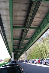
The A12 motorway bridge, the symbol of Flamatt

St. Beatus Chapel and Flamatt Customs House in Sense Bridge

Catholic Church Center of the Annunciation

Interior of the catholic church
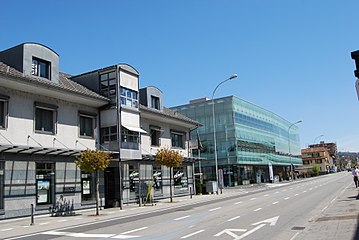
Main street in Flamatt

Chapel Sense Bridge
Reformed Church of David in Flamatt

Manor of the de Weck family , Blumisberg
_076.JPG)
_123.JPG)
_096.JPG)
_099.JPG)
_081.JPG)
_118.JPG)


Web links
- Official website of the municipality of Wünnewil-Flamatt
- Aerial view of Wünnewil
- Aerial views of Flamatt
- Moritz Boschung: Wünnewil-Flamatt. In: Historical Lexicon of Switzerland .
- Olivier Aebischer: Flamatt. In: Historical Lexicon of Switzerland .
Individual evidence
- ↑ Permanent and non-permanent resident population by year, canton, district, municipality, population type and gender (permanent resident population). In: bfs. admin.ch . Federal Statistical Office (FSO), August 31, 2019, accessed on December 22, 2019 .
- ^ Municipalities of the agglomeration of Bern. Federal Statistical Office, archived from the original on November 16, 2010 ; Retrieved August 7, 2009 .
- ↑ Imelda Ruffieux: At 30 km / h , traffic should run more smoothly. In: bernerzeitung.ch . October 7, 2019, accessed October 7, 2019 .
Alterswil | Bösingen | Brünisried | Düdingen | Giffers | Heitenried | Plaffeien | Plasselb | Keep right | Schmitten | St. Antoni | St. New Years Eve | St. Ursen | Tafers | Tentlingen | Ueberstorf | Wünnewil-Flamatt
Former municipality: Neuhaus | Upper shot | Zumholz
Canton of Friborg | Districts of the canton of Friborg | Municipalities of the canton of Friborg