
Gmina Święciechowa
| Gmina Święciechowa | |||
|---|---|---|---|

|
|
||
| Basic data | |||
| State : | Poland | ||
| Voivodeship : | Greater Poland | ||
| Powiat : | Leszczyński | ||
| Geographic location : | 51 ° 51 ' N , 16 ° 30' E | ||
| Height : | 94 m npm | ||
| Residents : | see Gmina | ||
| Postal code : | 64-115 | ||
| Telephone code : | (+48) 65 | ||
| License plate : | PLE | ||
| Economy and Transport | |||
| Street : | S5 Poznan - Wroclaw | ||
| DK12 to Głogów | |||
| Next international airport : | Poznań-Ławica | ||
| Gmina | |||
| Gminatype: | Rural community | ||
| Gmina structure: | 12 school offices | ||
| Surface: | 134.97 km² | ||
| Residents: | 8066 (Jun. 30, 2019) |
||
| Population density : | 60 inhabitants / km² | ||
| Community number ( GUS ): | 3013052 | ||
| Administration (as of 2014) | |||
| Wójt : | Marek Lorych | ||
| Address: | ul. Ułańska 4 64-115 Święciechowa |
||
| Website : | www.swieciechowa.pl | ||

Święciechowa [ ɕfjɛnt͡ɕɛˈxɔva ] is a rural municipality in the Powiat Leszczyński of the Greater Poland Voivodeship in Poland . Their seat is the village of the same name ( German Schwetzkau ) with about 3100 inhabitants.
geography
_location_map.png)
The municipality is located in the southwest of the voivodeship, about 70 kilometers southwest of the city of Poznan and 70 kilometers northwest of the city of Wroclaw . The municipality of Święciechowa includes the municipality of Leszno (Lissa) in the west and south. It borders the municipality of Rydzyna in the southeast , other neighboring municipalities are Góra in the Lower Silesian Voivodeship in the south, Wschowa in the Lebus Voivodeship in the east, Włoszakowice in the northwest and Lipno in the northeast. The village of Długie Nowe is located north of the triangle where the Greater Poland, Lebus and Lower Silesia voivodeships meet.
The territory of the municipality is characterized by three landscapes: the Leszno Plain (Równina Leszczyńska), an area with moraine hills and the Rowu Polskiego valley with alder forests . At Gołanice in the north of the municipality there is a small part of the Przemęcki Landscape Park (Przemęcki Park Krajobrazowy). There are three protected nature reserves in the municipality : In the north, forest areas near Gołanice and on Krzycko Lake near Krzycko Małe and near Henrykowo in the south.
The community has an area of 135 km², 61 percent of which is used for agriculture and 32 percent for forestry.
history
Today's municipality belonged as Gmina Leszno (until 1953) from 1937 to 1975 to the Pomeranian Voivodeship with different layouts. The rural municipality of Leszno was transformed into Gromadas in 1954 .
The Gmina Święciechowa was newly created on the territory of the rural municipality Leszno on January 1, 1973. From 1975 to 1998 she came to the Leszno Voivodeship . The Powiat Leszczyński was dissolved during this time. Since 1999 the municipality has belonged to the Greater Poland Voivodeship and again to the Powiat Leszczyński.

Between 1958 and 2017, six world and four European championships in gliding as well as one world and two European championships in hot air ballooning were held at the Leszno-Strzyżewice airfield .
Partnerships
The Gmina Święciechowa's community partnerships with Aixe-sur-Vienne (Nouvelle-Aquitaine) in France, Großhabersdorf (Middle Franconia) in Germany and Malinska received in Croatia.
local community

The rural community (gmina wiejska) Święciechowa with 8066 inhabitants (as of June 30, 2019) includes 12 villages with school offices (sołectwa):
| Surname | German name (1815-1920) |
German name (1939-1945) |
|---|---|---|
| Długie Nowe | New arbor | New building |
| Długie Stare | Old arbor | Old arbor |
| Gołanice | Gollmitz | Gollmitz |
| Henrykowo | Heinrichshof | Heinrichshof |
| Krzycko Małe | Klein Kreutsch | Kreutsch |
| Lasocice | Lasswitz | Lasswitz |
| Niechłód | Niches | Niches |
| Piotrowice | Petersdorf | Petersdorf |
| Przybyszewo | Priebisch | Priebisch |
| Strzyżewice | Striesewitz | Bar |
| Święciechowa | Schwetzkau | Schwetzkau |
| Trzebiny | Treben | Treben |
Other smaller settlements are: The Henrykowo settlement, the forest settlement Książęcy Las (Fürstenwalde) and Ogrody (Garthe) .
Listed sights
The following are entered in the register of monuments of the Greater Poland Voivodeship:
- St. Martin in Długie Stare
- Parish Church in Gołanice (1782)
- Neo-Gothic church in Krzycko Małe
- Wooden church in Niechłód
- Parish Church in Święciechowa
- Castle in Długie Stare
- Vorwerk in Długie Stare
- Castle and park in Trzebiny
- Manor house in Gołanice
- Manor house in Krzycko Małe
- Manor house in Niechłód
- Manor house in Przybyszewo
- Manor with mansion, park and stables in Strzyżewice (around 1900)
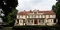
- Manor in Święciechowa
- Former customs house in Henryków
- Windmill in Święciechowa (1878)
Nine archaeological sites were placed under protection and entered in the register of cultural assets. There are four in Gołanice, two each in Długie Stare and Trzebiny and one in Lasocice.

Church in Długie Stare

Church in Krzycko Małe

Wooden church in Niechłód

Windmill in Święciechowa

Castle in Trzebiny
Manor house in Niechłód

Vorwerk in Długie Stare

Well in Strzyżewice

.jpg)


Economy and Infrastructure
traffic
The S5 expressway ( E 261 ) runs through the east of the municipality in the Leszno bypass from north to south. From the Leszno-Południe junction, Poznań-Zachód is 70 kilometers and Wrocław-Północ is 77 kilometers. The national road DK12 (droga krajowa 12) runs from east to west through the area of the municipality and leads from Leszno to Głogów (Glogau) . The voivodship road DW323 leads from the southeast of the municipality to Lubin in Lower Silesia.
The nearest long-distance train station is in Leszno on the Breslau – Poznan and Łódź – Forst (Lausitz) railway lines . The village of Lasocice has a service station on the latter.
The nearest international airport is Poznań-Ławica, 70 kilometers away . - The Leszno-Strzyżewice airfield ( ICAO code : EPLS), which belongs to the city of Leszno, is located about halfway in the municipality .
Economy and education

The community is shaped by agriculture . The farmers grow feed and breed pigs . The largest gliding school in the country used to be located at the airfield.
In Święciechowa there is a school center with elementary and secondary school (Zespół Szkół Szkoła Podstawowa i Gimnazjum).
Web links
- Community website (Polish)
Individual evidence
- ↑ population. Size and Structure by Territorial Division. As of June 30, 2019. Główny Urząd Statystyczny (GUS) (PDF files; 0.99 MiB), accessed December 24, 2019 .
- ↑ a b c d e f O gminie . (Polish, accessed April 12, 2020)