
Slovenske Konjice
|
Slovenske Konjice Gonobitz |
|||
|
|||
| Basic data | |||
|---|---|---|---|
| Country |
|
||
| Historic region | Lower Styria / Štajerska | ||
| Statistical region | Savinjska (Sann area) | ||
| Coordinates | 46 ° 21 ' N , 15 ° 22' E | ||
| surface | 97.8 km² | ||
| Residents | 14,726 (January 1, 2017) | ||
| Population density | 151 inhabitants per km² | ||
| Post Code | 3210 | ||
| License Plate | CE | ||
| Structure and administration | |||
| Mayor : | Darko Ratajc (2019) | ||
| Mailing address | Stari trg 29 3210 Slovenske Konjice |
||
| Website | |||


Slovenske Konjice ( German : Gonobitz ) is a small town and municipality in Slovenia . It is located in the historical Spodnja Štajerska ( Lower Styria ) region and in the statistical region of Savinjska .
Alternative spellings
Counowiz (1146), Gonviz (1251), Gombicz (1370), Gannabitz (1570), Gonaviz (1594), Gonavitz (1630), Gonwitz (1636), Gonowitz (1662), Ganowiz (1680), Gonnawitz (1680)
geography
location
Slovenske Konjice is located in the upper Dravinja Valley (Drann) in an area where the river forms a small plain. The area is surrounded by a hilly landscape. The city center itself is 322 m. i. J. , the highest elevation is the mountain Stolpnik (Landthurmberg) with 1012 m. i. J. on the border with the municipality of Zreče .
The next larger cities are Celje about 17 km southwest and Maribor about 30 km northeast.
Community structure
The municipality comprises 58 localities. The German exonyms in brackets were mainly used by the German-speaking population until the area was ceded to the Kingdom of Serbs, Croats and Slovenes in 1918 and are largely uncommon today. (Population figures as of January 1, 2017):
- Bezina (Wosina), 585
- Blato (Kothdorf), 109
- Brdo (Werdu), 90
- Breg pri Konjicah, 147
- Brezje pri Ločah (Bresje), 111
- Dobrava pri Konjicah, 83
- Dobrnež, 122
- Draža vas (Gattersdorf), 517
- Gabrovlje (Gabrolle), 64
- Gabrovnik (Gabounig), 216
- Kamna Gora (Steinberg), 102
- Klokočovnik (Klokotschounig), 186
- Koble, 115
- Kolačno (Kollachno), 45
- Konjiška vas (Gonobitz village ), 206
- Kraberk (Krahberg), 73
- Ličenca (Litschenza), 183
- Lipoglav (Lipoglau), 214
- Loče (Holy Spirit), 642
- Mali Breg (Breg), 59
- Mlače , 242
- Nova vas pri Konjicah (Neudorf), 74
- Novo Tepanje, 85
- Ostrožno pri Ločah (Ostroschno), 17
- Penoje, 35
- Perovec (Perowetz), 39
- Petelinjek pri Ločah (Petelinegg), 47
- Podob, 18th
- Podpeč ob Dravinji (Podpechin), 58
- Polene (Polena), 233
- Preloge pri Konjicah (Preloge), 150
- Prežigal (Prischigat), 24
- Selski Vrh (Werch), 78
- Slovenske Konjice (Gonobitz), 5,027
- Sojek (Soiegg), 104
- Spodnja Pristava (Unterpristova), 32
- Spodnje Grušovje (Untergruschoje), 196
- Spodnje Laže ( lower plate ), 147
- Spodnje Preloge, 350
- Spodnji Jernej, 28
- Stare Slemene (Altslemene), 113
- Strtenik (Stertenegg), 54
- Suhadol (Suchadol), 51
- Sveti Jernej (Sankt Bartholomä), 186
- Škalce (Skallitz), 450
- Škedenj (Stadl), 73
- Špitalič pri Slovenskih Konjicah (Maria Spitalitsch), 9
- Štajerska vas, 42
- Tepanje (Tepina Village), 516
- Tepanjski Vrh (Tepinaberg), 151
- Tolsti Vrh (Feistenberg), 105
- Vešenik (Hangenberg), 412
- Zbelovo (plank stone village ), 265
- Zbelovska Gora (Plankensteinberg), 320
- Zeče (Setsche), 231
- Zgornja Pristava (Oberpristova), 187
- Zgornje Laže ( upper flap ), 140
- Žiče (Seitzdorf), 588

Castle after an engraving by Vischer (1680)

Parish Church of St. George

The square Stari trg (German roughly: Alter Platz ) in the city center
Trebnik Castle


Parish Church of St. George


Neighboring communities
| Zreče | Oplotnica | Slovenska Bistrica |
| Vojnik |
.svg)
|
Poljčane |
| Šentjur pri Celju | Šentjur pri Celju | Šmarje pri Jelšah |
history
The Lords of Gonobitz first appeared in the middle of the 12th century, presumably as ministerials to the sovereign. Leopold de Gonvicz sold the margrave Ottokar III. the Seizer valley for the new Carthusian monastery Seiz .
The parish church of St. Georg was first mentioned in 1146, but is of earlier origin.
Most of the castles and courtyards that have survived to this day are from the 15th century: Trebenek (Slov. Trebnik ) (1404), Hebenstreit (Slov. Hebenštrajt ) (1476), Dobiehof (Slov. Dobje ) (1497), Golitsch (Slov . Golič ) (1542).
Until after the First World War, Gonobitz was the center of a German-speaking island, which also included the surrounding villages of Kotdorf, Prerauth and Pristowa. In these places the German speakers formed a majority of 80–90%.
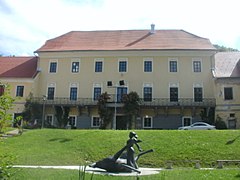
Gonobitz Castle
Gonobitz Castle fell into disrepair after the execution of Hans Erasmus von Tattenbach and was sold to the Carthusian Monastery of Seiz for 48,331 guilders after being refunded by his brothers.
After the Carthusian monastery was dissolved by Joseph II , Hugo Weriand Prince zu Windisch-Graetz bought the Gonobitz rule from the religious fund in 1828 .
| Owner of Gonobitz Castle | year |
|---|---|
| Lords of Gonobitz | 1148-1329 |
| Lords of Wilthausen | 1329-1385 |
| Lords of Duino | 1385-1406 |
| Lords of Walsee | 1406-1469 |
| Prince ( Habsburg ) | 1496-1576 |
| Johann von Khißl | 1576-1592 |
| Archduke Ferdinand II. | 1594-1597 |
| Count Tattenbach | 1597-1670 |
| Emperor | 1670-1685 |
| Joh. And Otto Tattenbach | 1685-1692 |
| Charterhouse Seiz | 1692-1783 |
| Religion fund | 1783-1828 |
| Prince of Windisch-Graetz | 1828-1945 |
-former_train_station_1902.jpg)
traffic
The A1 motorway
![]() runs right through the municipality and can be reached through the "Slovenske Konjice" junction.
runs right through the municipality and can be reached through the "Slovenske Konjice" junction.
In addition, a piece of the Šentilj-Zidani Most railway line touches the municipality in the south-east, but the closest train stations Poljčane and Dolga Gora are outside the municipality and thus each about 10 km from the city center. For this reason, a narrow-gauge local line Poljčane-Slovenske Konjice existed until 1962 , which offered a connection to the main line. This began operations in 1892 and was even extended to Zreče in 1921 , after which the tracks were finally dismantled again.
Twin cities
Sister cities of Slovenske Konjice are:
-
 Hlohovec ( Freistadt an der Waag ), Slovakia (2007)
 -
 Kosjerić , Serbia (2009)
 -
 Hranice ( Mährisch Weißkirchen ), Czech Republic (2012)
 -
 Gornja Stubica , Croatia (2013)
 -
 Tolfa , Italy (2016)
 -
 Százhalombatta , Hungary (2016)
 -
 Swjosdny Gorodok , Russia (2016)
 -
Biograd na Moru , Croatia (2019)
sons and daughters of the town
- Konrad von Hebenstreit († 1412), Prince-Bishop of Freising
- Hans Erasmus von Tattenbach (1631–1671), castle owner
- Benno von Millenkovich (1869–1946), Austrian Rear Admiral
- Alois Oswatitsch (1874–1959), painter
literature
- Muchar: History of the Duchy of Styria , Graz 1844.
- Proschko : Erasmus Tattenbach , Graz
- Association of Historic Cities of Slovenia: Cities of Culture
Web links
- Slovenske Konjice , official website of the municipality
- Map of the municipality of Slovenske Konjice
Individual evidence
- ^ Special map of the Austro-Hungarian Monarchy 1: 75,000 - Pragerhof and Wind. Feistritz 5455. (1914)
- ↑ Population tables of the Statistical Office of the Republic of Slovenia ( Slovene )
- ^ Gerhard Werner, Language and Volkstum in der Untersteiermark (Stuttgart 1935), p. 105.
Braslovče · Celje · Dobje · Dobrna · Gornji Grad · Kozje · Laško · Ljubno · Luče · Mozirje · Nazarje · Podčetrtek · Polzela · Prebold · Rečica ob Savinji · Rogaska Slatina · Rogatec · šentjur · Konjice · Šmarje pri Jelšah · Šmartno whether Paki · Solčava · Šoštanj · Štore · Tabor · Velenje · Vitanje · Vojnik · Vransko · Žalec · Zreče