
Reason (Vejprty)
| Vejprty reason | |||||
|---|---|---|---|---|---|
|
|||||
| Basic data | |||||
| State : |
|
||||
| Region : | Ústecký kraj | ||||
| District : | Chomutov | ||||
| Municipality : | Vejprty | ||||
| Geographic location : | 50 ° 31 ' N , 13 ° 2' E | ||||
| Residents : | |||||
| Postal code : | 431 91-431 94 | ||||
| License plate : | U | ||||
| structure | |||||
| Status: | settlement | ||||


Vejprty-Grund (German Weipert-Grund ) is a locality of Vejprty (Weipert) in the central Ore Mountains , Czech Republic . It is located north of Vejprty am Pöhlbach and on the border with Germany opposite the Bärensteiner district of Kühberg . The former settlement was the oldest part of the Czech border town Vejprty (Weipert). Due to its location on the border with Germany , the district was almost completely demolished after 1945.
geography
.jpg)

location
The corridor of Vejprty-Grund is located on the ridge of the Middle Ore Mountains on the valley slope of the border with Germany (Free State of Saxony ) in the west and north, which forms the Pöhlbach (Czech: Polava ) in the west . In the south, the urban area of Vejprty connects.
The former development had the character of a scattered settlement . It spread north of the urban area of Weipert in the corner between the border bridge of the Vejprty – Annaberg-Buchholz railway line, which has existed since the 19th century, across the Pöhlbach in the west and the road to the Weisse Hirsch in the southeast. The main settlement areas were the valley of the Pöhlbach, u. a. the Blechhammer in the north, the old pass road in the east and an area in the west where the last houses of the district that still exist today are located (today's streets "Údolní", "Hasičská", "Havířská", "Máchova", "U Mostu", "Nouzov" and "Pohraniční").
The former border crossing at Blechhammer to Kühberg was closed after 1945. Today there is only a small crossing for hikers in its vicinity.
Neighboring places
| Kühberg | ||
| Bear stone |
.svg)
|
|
| Vejprty (Weipert) | Weißer Hirsch settlement (zu Jöhstadt) |
history
Beginning of the settlement of Weipert-Grund
The history of the oldest Weipert district of Grund is closely linked to the Preßnitzer Pass (Preßnitzer Straße), which was first mentioned in a document in 1335 . This originally led from Halle (Saale) via Altenburg , Zwickau , Hartenstein , Grünhain , Zwönitz and Schlettau to Kühberg in the valley of the Pöhlbach, where it was passed over the “Bohemian Bridge” at the height of the later Blechhammer. This was called the "Landbrücke" by the Erzgebirge chronist Christian Lehmann . The "Behmische Brucken" appears u. a. in the loan letter of May 20, 1546 for Ilgen Wegener, where she describes the lowest point of his property, the corner between Pöhlbach ("Bernsteiner Wasser") and the pass road ("Bernsteiner Straßen"). From there the Preßnitzer Pass continued via Weipert (today: Vejprty), Pleil (today: Černý Potok ), Preßnitz (Czech. "Přísečnice", today located in the reservoir area of the Preßnitz dam ) to Reischdorf (today: Rusová ), in its locality it branched out in the direction of Kaaden (today: Kadaň ) and Kralupp (today: Kralupy u Chomutova ). Since the Bohemian rule of Schlettau on the other side of the Pöhlbach was sold to the Grünhain monastery by Fritz von Schönburg auf Hassenstein (today: Hasištejn) in 1413 , the Pöhlbach has formed the Saxon-Bohemian border in the area of the later district of Grund. The fact that iron ore mining has existed in the forest area between Weipert, Pleil-Sorgenthal and Preßnitz since at least the 15th century is proven by the mention of the hammer Wyprecht or the boundary sign "by dem wyprechte" in the sales deed of the Schlettau lordship of January 20, 1413 The hammer mill fell wildly in the following years, as evidenced by feudal deeds from 1526 and 1573, which speak of the "desert hammer Weyberth". The deed of 1526 confirmed the enfeoffment of Hans Schneider with the wild hammer Weiperth in 1506. This was close to the border bridge and should not be confused with the later tin hammer.
At the time of the Thirty Years' War (1618–1648), the pass path formed into a ravine at the border formed a protective wall against the Swedish armies, which is why it was also called "Schwedenschanze". It could be blocked with logs. In 1641 the battle of Pressnitz raged in the Pleiler Heide above Weipert-Grund . In 1644, the imperial troops quartered themselves in the sheet metal hammer in the lower part of the path.

Vejprty-Grund, start of the ravine on the Alter Passweg at Blechhammer

Vejprty-Grund, old pass path (ravine)

_(4).jpg)
The tin hammer in Weipert-Grund


The pass road had to overcome enormous gradients in the valley of the Pöhlbach on the Saxon and Bohemian side, which can still be seen today on the ravines on the Bohemian side towards the Weißer Hirsch . Directly on the Bohemian side behind the “Bohemian Bridge”, where the pass road crossed the Pöhlbach and the state border, there was therefore an inn (Fuhrmannschenke), which served as a place to relax and a hostel for travelers . The Bohemian Bridge was located a few meters upstream from today's road bridge from Kühberg to Jöhstadt .
Down the valley, the inn at the Böhmische Brücke was the lowest house in Weipert and was located immediately to the right of the Pöhlbach at the point where the border leaves the Pöhlbach. It was mentioned as early as 1661 and was undoubtedly one of the oldest buildings in Weipert. By decree of the emperor, a water-powered hammer mill was built opposite the inn in 1661. This annually produced 700 m² of galvanized sheet metal. This is why the area around the hammer was popularly known as "Ziehbusch". Already in the year of construction of the hammer mill, as in the following years, there were disputes over water usage rights with the Annaberg city council and the neighboring town of Bärenstein on the Saxon side. The background was that too little water was available for all users during drought, but Bärenstein and the Annaberger Floßgraben had privileges. In the course of the Counter-Reformation , after 1660, numerous Protestant workers from Weipert-Grund settled in the neighboring Saxon town of Bärenstein because of their beliefs , as evidenced by the baptismal register of the Bärenstein church.
In 1697 the production of sheet metal was stopped. It was only resumed in the first third of the 18th century. Later, a paper mill was operated in the hammer mill, which was named "Trinksmühle" (house no. 8) after its owner. In addition to paper, it also produced cardboard for packaging materials.
For the inn opposite the mill, the name Blechhammer has become common over the years . This tavern was originally called "Plechtal", later "Zur Weintraube" and popularly "Wildes Eck". This restaurant, popular in the Weipert area, was sold to the city in 1749. After a fire it was demolished in 1880. In their place, modern factory halls were built, in which tricots and trimmings were made. Between 1839 and 1945 the Schmidl family was the majority owner of the “Blechhammer” industrial complex. In 1851 the "Passamentenfabrik Julius Schmidl & Co." was founded. In the 1930s 150 people were employed in the company. The restaurant was still a popular excursion restaurant up to this time.
The Grund district of Weipert until 1938


.jpg)

The Weipert district of Grund came into being later than the Blechhammer. Some houses of the scattered settlement, which spread north of the Weipert city area, were already in the 17th century. Due to its location in the valley of the Grenzbach Pöhlbach, the urban area of Weipert is long and narrow. Because of its distance from the center of Weipert, the reason was called the " Balkans " and the tin hammer, which is even further away, " Herzegovina ". In 1770, by resolution of the Archduchess of Austria and Queen of Bohemia , Maria Theresa, the existing houses in Weipert were numbered “starting from the tin hammer”.
The district of Grund had an extension from the boundary angle between the railway bridge over the Pöhlbach in the west, which had existed since the 19th century, along the Pöhlbach to the Blechhammer in the north and from there at a right angle along the old pass road to the Weißen Hirsch in the southeast. Over time, numerous houses, factories and workshops were built along the Grenzbach and the Alter Passweg. Houses No. 1 to 6 were built on the Alter Passweg, which, due to the extensive use, consisted of several parallel hollow paths . Houses No. 3 to 5 at the intersection of the Alter Passweg and Jöhstädter Strasse were in earlier times anchoring houses where the Carriages of horses were harnessed for the ascent, other rented draft animals. Other buildings were u. a. the Ehrenfeld factory (no. 880), in which trimmings were made, as well as the houses and villas of factory owners from the 19th and 20th centuries and farms. At the upper end of the pass road, not far from the “Katharinafelsen”, were houses no. 1 and 2. From around 1900 the well-known restaurant “Wolfsschmiede” was located in house number 2, the original name of which was “Stadt Weipert”. The actual “wolf forge”, from which the inn got its name, was on the Saxon side near the White Deer. It is not known when this was abandoned. About 15 meters behind the two buildings of the Bohemian Wolfschmiede and the neighboring house, you reached the Bohemian-Saxon border, from which the pass road continued to the White Deer . There was a forester's house on the Bohemian side and the inn and forester's house on the Saxon side, now known as the "Berghof".
In the west of the town hall from Grund there was another settlement core between the border at the Pöhlbach in the west and the street known today as “Údolní”. In this area, house no. 650 stood on the left side of Grundmühlstrasse (later called Anton-Günther-Strasse or Smetanova třída) until the 1950s. This was the architecturally interesting villa of Josef Pohl. On the slope below, Pohlmühlstrasse (later: Mlýnská ulice) was followed on the right by the magnificent building by Anton Pohl at number 442. In the lower part of Pohlmühlstrasse was the spinning mill of the company "Franz Pohl und Sons" (house no. 22), which was originally "Bärenmühle" was called. The history of the Pohl family in Weipert began in 1804 when Franz Pohl moved from Rumburg to Weipert as a traveling salesman for stockings . In the following year he bought house no. 4 on Alten Passweg and started his own stocking production in Weipert. In 1806 he founded the company “Franz Pohl”, which was later renamed “Franz Pohl and Sons” and around 1880 to “Franz Pohl's Sons Successors”. On the day of the funeral of a son of Franz Pohl, the spinning mill (house number 22) burned out completely. After that, the production of stockings, socks, gloves and hats with modern knitting machines was oriented and expanded to the surrounding areas. At the end of the 19th century, the company employed 350 machine workers, 100 unskilled workers and 150 seamstresses, who received above-average coverage for the time (accident and health insurance, supplementary pension). The Pohl family had become the richest family in Weipert around 1900, and they also made charitable contributions to the city. The brothers Franz, Josef and Anton Pohl donated a hospital to their hometown, which was inaugurated in 1891. This building (house no. 670) is used as assisted living today. In 1902 a house for nuns (house no. 875a) and a hospital were added. In 1893 the brothers were named honorary citizens of the city. They also supported the construction of the school in the Grund district (house no. 705) financially and gave money for the construction of monuments. The "Pohlsche support fund" existed since 1853, with which the sick and needy were supported.
Not far from the Pohlschen villas was the "Grundmühle" inn, built in 1903, which was never a classic mill. Due to its idyllic location in the "Ziehbusch", the striking building with the little pointed tower was a popular excursion destination. The building had a large dance hall, a viewing terrace and a covered gazebo. After the innkeeper's son died in World War I and the innkeeper died in the same year, the innkeeper Anna Anger gave up the inn in the same year. A factory was set up in the restaurant between 1922 and 1926. It was only after 1927 that the Grundmühle became a popular restaurant again, until the Second World War finally brought it to an end. In the north-west of Weipert-Grund, the company "Brauer & Gutberlet", which was founded in 1905 and manufactured cardboard boxes, was located directly on the Pöhlbach. Later it became the limited partnership of Gustav Rupprich and Josef Nausch. There in the "Golden Valley" was also the excursion restaurant "Goldenthal".
Around 1912 there were well-advanced plans to extend the narrow-gauge railway Wolkenstein – Jöhstadt across the Saxon-Bohemian border to Weipert station . This project envisaged a train station each in Pleil and in the Bohemian group of houses "Weißer Hirsch" (opposite the Saxon group of houses Weißer Hirsch ) on the Conduppelbach . The planned narrow-gauge railway line would have been integrated into Weipert station via an arch over the Grund district from the north. Because of the First World War and the political changes after the war, the project did not get beyond a design plan.
As part of the city of Weipert, the land originally belonged to the Preßnitz rule . After the revolutionary years of 1848/49 in the Austrian Empire , patrimonial jurisdiction was repealed. It was replaced by the judicial district of Preßnitz , from which the judicial district of Weipert was split off in 1901/02 . This was assigned to the newly founded Preßnitz district . With the defeat of the Austro-Hungarian Army in World War I in 1918 and the end of Austria-Hungary on October 31, the end of the crown land of Bohemia was sealed. As a result, the Grund district of the Bohemian city of Weipert was officially incorporated into the new Czechoslovak Republic in 1919 .
The Grund district of Weipert from 1938 until it was demolished in the 1950s
.jpg)
In 1938, border barriers made of vertical railway tracks were erected on the border bridge over the Pöhlbach. After German troops occupied the Sudetenland and with it the city of Weipert after the Munich Agreement in October 1938, they were incorporated into the Preßnitz district in the Reichsgau Sudetenland on October 10, 1938 . As a result, the state border to Kühberg ceased to exist in October 1938. The division of the Preßnitz district planned in 1939 and the incorporation of the Weipert judicial district into the Sankt Joachimsthal district were not carried out until 1945. In 1938 there were eight large factories in Weipert-Grund, of which the Blechhammer alone had 150 employees. There were also eight workshops, a hotel, six inns, five bakeries, two butchers, three tobacconists , seven grocery stores, one saw and one timber shop, three coal dealers, three hairdressers and four haulage companies in the district.
After the end of the Second World War , Czechoslovakia was re-established in 1945 within the limits from the time before the Munich Agreement, to which the town of Weipert, now known as Vejprty, and its districts belonged again. It was now administered by the Okres Chomutov . The pedestrian crossing over the “Bohemian Bridge” between Kühberg and the Blechhammer in Vejprty-Grund was closed due to the changed political situation in 1945. Between 1945 and 1946 the predominantly German-Bohemian population was expelled . Due to the direct proximity to the state border, the houses initially remained uninhabited and fell into disrepair. After 1945, the lounge of the "Grundmühle" served as a hay store for the horses of the border gendarmerie. Work continued in the factories in the Grund district. After a suspected arson, the tin hammer burned to the ground in 1947.
In 1952, the government of Czechoslovakia decided to set up a 100-meter-wide border strip with border fences and watchtowers. As a result, the entire northern part of Vejprty-Grund, which protruded far into the Saxon area, fell into the area of the restricted border area. All buildings in it, d. H. Houses, villas and factories were razed to the ground by 1953. This concerned u. a. the houses and factories at Blechhammer, the houses on the Alten Passweg including the “Wolfsschmiede”, the houses, factories and villas of the Pohl family, the “Grundmühle” bar, the buildings of the former Brauer & Gutberlet company in the Golden Valley and the houses at the Jöhstädter Strasse. The "Anton-Günther-Ruh" was also in the restricted area and was forgotten due to its destruction. The only buildings in the district of Grund that were spared from demolition were the houses around the school in the district.

Vejprty-Grund, foundations of a demolished house (2017)

Vejprty-Grund, ruins on the former Jöhstädter Straße (2017)

Vejprty-Grund, House remains (2017)

.jpg)

Situation from the 1950s to the present
.jpg)
.jpg)
.jpg)
In the mid-1960s, the forbidden zone of the restricted border area was lifted again. Nevertheless, the former development of the district was irretrievably destroyed. Numerous remains of the building, u. a. the foundation walls of the Grundmühle and the houses on Jöhstädter Straße, the cellar vaults of the inn at the Blechhammer and the ruins of the Blechhammer have survived to this day, but are partly overgrown with trees and bushes. The name of the tin hammer that burned down in 1947 was transferred to the holiday hotel in Kühberg, built around 1980 on the opposite Saxon side.
With the political change in the GDR and the Velvet Revolution in Czechoslovakia in 1989 and the associated incorporation of the GDR into the Federal Republic of Germany in 1990 and the establishment of the Czech Republic in 1993, relations between the two countries also changed. The opening of the state border was further facilitated by the accession of the Czech Republic to the European Union in 2004 and the accession to the Schengen Agreement in 2007. This made the corridor of the former Grund district fully accessible again.
In 2010, after years of searching, a Bärenstein resident discovered the remains of the former memorial site of "Anton-Günther-Ruh". The newly founded association "Denkmalpflege Weipert eV" restored and refurbished the memorial stone and its surroundings in the following years. On July 3, 2013, the "Anton-Günther-Ruh" was ceremoniously rededicated with the participation of 600 guests. On July 8, 2017, a song festival took place there for the fifth time, which was organized by the association "Denkmalpflege Weipert eV" and the city of Vejprty. In the years 2012/13 the area of the Hubertusfelsen not far from the "Anton-Günther-Ruh" by the association "Denkmalpflege Weipert eV" and the city of Vejprty was freed from wild growth and made accessible again. In 2014 the “Dr. Illner memorial stone” was moved from the former school in Grund to its current location next to the Hubertusfelsen. Furthermore, the association "Denkmalpflege Weipert eV" set up information boards in German and Czech at important locations in the Grund, u. a. at the Blechhammer, at the Wolfsschmiede, at the Pohl-Villen, at the Anton-Günther-Ruh, at the Hubertusfelsen and at the Grundmühle. Not far from the former pedestrian crossing at Blechhammer, the state border can be crossed via a small path, which means that the "Anton-Günther-Ruh" can also be reached from Kühberg. The remains of the rails from the border barriers from 1938 are visible again in the concrete after the foundations have been exposed. In the area of Jöhstädter Straße there is now a small ski slope with a lift.
On the mountain Bärenstein on the Saxon side there is the "Gründner Bank" and an information board that reminds of the Grund district. From there you have a good view of the former place.
Attractions
- Hubertusfelsen
The “Weipert Hunting Club” founded in 1907 gave the mighty rock in the west of the Grund district the name of its patron saint and carved it in stone. For the 25th anniversary a memorial plaque was anchored in the rock in 1932, which was violently stolen in 2010. In the years 2012/13 the area was cleared of wild growth and made accessible again by the association “Denkmalpflege Weipert eV” and the city of Vejprty.
- Illner monument
The memorial stone Dr. Illner recalls Dr. med. Franz Illner (1855–1924), who was city doctor and honorary citizen of the city of Weipert. Dr. Illner took good care of the poor and the sick in the city. One year after his death in 1925, a memorial stone was placed in front of the school in Weipert-Grund. In 2014 this was set up by the “Denkmalpflege Weipert eV” association at its current location next to the Hubertusfelsen.
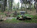
- Anton-Günther-Ruh
In honor of the Erzgebirge folk poet and native singer Anton Günther , who died a year earlier , the “Anton-Günther-Ruh” was consecrated on July 3, 1938 in the “Ziehbusch” in Weipert-Grund. It was donated by the Weipert entrepreneur and nature lover Karl Walter Schmidl. To do this, 2000 cubic meters of rock had to be moved. In 1945 the memorial in the now restricted border area was destroyed and was no longer found. In 2010, a Bärenstein resident discovered the remains of the former memorial after years of searching. The newly founded association “Denkmalpflege Weipert eV” restored and refurbished the memorial stone and its surroundings in the following years. On July 3, 2013, the "Anton-Günther-Ruh" was ceremoniously rededicated with the participation of 600 guests.

Hubertusfelsen in Vejprty-Grund
Vejprty-Grund, Dr. Illner memorial

Anton-Günther-Ruh in Vejprty-Grund

Vejprty-Grund, rocks by the former Grundmühle

.jpg)

.jpg)
Web links
- The Weiperter district of Grund on www.weiperter-vorfahren.de
- Blechhammer and Bohemian Mill in the Official Gazette of the Bärenstein Municipality, edition 08/2012, page 7
- Buildings and locations in Weipert on the website of the Weipert eV monument care association
- Weipert and mention of the district of Grund on www.pressnitzerkreis.de
Individual evidence
- ↑ The Preßnitzer Pass on a private website about Königswalde
- ↑ Anzeiger der Gemeinde Bärenstein, Edition 08/2012, p. 7 ( Memento of the original from April 20, 2017 in the Internet Archive ) Info: The archive link was inserted automatically and has not yet been checked. Please check the original and archive link according to the instructions and then remove this notice.
- ↑ The hammer mill in Weipert-Grund in the Anzeiger der Gemeinde Bärenstein, edition 07/2011, page 11 ( Memento of the original from November 26th 2013 in the Internet Archive ) Info: The archive link was inserted automatically and not yet checked. Please check the original and archive link according to the instructions and then remove this notice.
- ↑ Anzeiger der Gemeinde Bärenstein, Edition 01/2011 ( Memento of the original from April 20, 2017 in the Internet Archive ) Info: The archive link was automatically inserted and not yet checked. Please check the original and archive link according to the instructions and then remove this notice.
- ↑ Mention of the tin hammer in Weipert-Grund on www.weiperter-vorfahren.de
- ↑ Die Wolfsschmiede in the official gazette of the municipality of Bärenstein, edition 05/2013, p. 10 ( Memento of the original of December 5, 2017 in the Internet Archive ) Info: The archive link was inserted automatically and not yet checked. Please check the original and archive link according to the instructions and then remove this notice.
- ↑ The house no. 670 on the website www.weiperter-vorfahren.de
- ↑ Die Böhmische Brücke in the official gazette of the municipality of Bärenstein, edition 08/2012, p. 7 ( Memento of the original from April 20, 2017 in the Internet Archive ) Info: The archive link has been inserted automatically and has not yet been checked. Please check the original and archive link according to the instructions and then remove this notice.
- ↑ Photo of the school in the Grund (No. 705) on www.weiperter-vorfahren.de
- ^ Historical aerial photo from 1953 on a Czech website
- ↑ Historical photo of Anton-Günther-Ruh in Weipert-Grund
