Hair (Westphalia)
| Hair (strand) | ||
|---|---|---|
| Highest peak | Peak waiting room ( 391 m above sea level ) | |
| part of | Hellwegbörden | |
| Classification according to | Handbook of the natural spatial structure of Germany | |
|
|
||
| Coordinates | 51 ° 31 ' N , 8 ° 27' E | |
| rock | Limestones of Turonian and Cenomanian | |
| surface | by 300 km² | |
With hair or hair strand one is ridge on the southern edge of the Westphalian bay called. The hair strand extends from west to east in the south of the city of Dortmund and the districts of Unna and Soest in North Rhine-Westphalia . In terms of natural space , it represents the submontane southern part of the Hellwegbörden , which faces north of Möhne and Ruhr with the north of the Süderbergland .
The highest point is at 391 m above sea level. NHN the tip waiting , which is at Rüthen - Hemmern at the eastern end of the hair strand. Further west, the ridge of the ridge usually reaches heights of 200 to 250 m above sea level. NHN and thus rises about 100 to 150 m above the Ruhr and Möhne valley in the south and the valley of the Lippe in the north , separated by Upper and Lower Hellweg , both also part of the Hellwegbörden .
The approximately 300 km² hairline is entirely agricultural and has retained its rural character even in the westernmost part, which occupies the southeast of Dortmund and subdivisions of other cities in the Ruhr area.
Origin of name
The term “hair” (fem.) Can also be found as part of the name of other altitude formations, such as the “Rothaar” in the southern Sauerland (cf. Rothaargebirge ) or also with the Haard north of the Ruhr area. In north-west Germany, “Haar” generally refers to a wooded ridge, related to the name “Hardt”, see Hardt (toponym) . Is poised to Forest (derived from tree resin to be) the basic meaning, see. the flatland forest Davert ("Taubenwald") near Münster. As evidenced by some place names (e.g. “ Ruploh ”) as well as existing residual forests, the hair strand was largely forested until the Middle Ages.
Natural structure
The hair strand is structured as follows:
-
(to 542 Hellwegbörden )
-
542.3 strand of hair
- 542.30 hair height
- 542.31 Southern Hair
- 542.310 Herdicker Hair
- 542,311 swords loess terraces
- 542.312 Bentrop Hair
-
542.3 strand of hair
The hair height forms the actual core ridge between Holzwickede the west and Büren in the East, the South face rugged to Möhne and Ruhr drops, while north transitions to the valley of the lip stepwise with (not belonging to the hair strand) upper and lower Börden gradually move forward. In contrast, the slopes of the two south-branching sub-areas of the Süderhaar to the Ruhr are more gently inclined and have more the character of the Oberbörden on the north side of the Haarstrang. The Bentroper Haar near Bentrop is spatially separated from the Herdicker Haar of the Holzwickeder districts Opherdicke and Hengsen with the moated castle Haus Opherdicke in the extreme southwest, the southern part of which merges further to the southwest into the shallow Schwerter Terrasse around Schwerte , while parallel to it the west into the basement cortex of the Ardeygebirge flows, which as part of the Niederbergisch-Märkischen hill country already belongs to the southern mountains .
geology
The strand of hair made of limestones from Turon and Cenomanians formed the natural limit for the advance of the northern glaciers of the Ice Age . It is considered to be one of the sharpest landscape borders in Central Europe. To the north of the hairline there are numerous ground and terminal moraines .
Soil and vegetation
The hair strand itself, unlike its northern neighboring landscapes, has rather shallow, stony and loamy soils made of rendzine and brown earth , which is only productive for agriculture down the slope in the north, where the proportion of loess increases noticeably. Mainly oats , barley and wheat are grown there, while other pastures predominate.
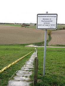
In the eastern part there is still limited limestone vegetation, which is rare for the rest of the region . The loamy soil quality in large parts of the hair leads to strong superficial water runoff, in contrast to the Paderborn plateau to the east , which shows karst phenomena (strong seepage, underground runoff). The runoff of the hair in heavy rain can lead to sudden flooding through the drainage channels of the ridge ( Schledden ) at the northern foot of the ridge. As a result, there were fatalities in the 1960s ( Ostönnen 1968). Today, the lower upper and lower regions are protected by flood retention basins (HRB) in the main channels, for example east of Meiningsen with the HRB Meiningsen on the Theiningser Schledde (or Grund ) .
Natural resources
The green sandstone deposits at Anröchte ( Anröchter Stein ) are economically significant, there is also lime mining at Erwitte and Geseke .
traffic
The historic Haarweg trade route ran over the crest of the Haarstrang, which branched off from Hellweg to the south in Werl and, running parallel to it to the east, followed the valley of the Alme from Büren and flowed back into Hellweg in Paderborn . The western part of its course up to and including the north of the Möhnetalsperre is followed today by a section of the federal highway 516 .
The main east-west axis, however, the room is on the north parallel upper Börden running Bundesautobahn 44 . Paderborn / Lippstadt Airport is located in the far east of the Oberbörden .
The Lippstadt – Warstein railway, which crosses the Haarstrang in a north-south direction, has only been used for freight traffic since 1975.
Wind energy
The exposed position of the hair allows generous use of wind power . The generation of electricity is very economical here, the wind has a speed of about 6 meters / second at a height of 50 meters. Since 1997, the municipality of Anröchte has designated a concentration area for around 48 plants. The plants generate 65 to 70 million kWh on an annual average.
view

Provided that the visibility conditions are appropriate, you can see from exposed parts of the Haar (e.g. at the Bismarck Tower near Wippringsen ) in the north to deep into the Westphalian Bay (in the northeast to the Dörenschlucht in the Teutoburg Forest , in the north to the Beckum Mountains , in the northwest to the power stations and chimneys north and west near Hamm ). In the west, when visibility is good, the Dortmund television tower can be seen up to a distance of about 60 km . The view to the south, on the other hand, extends deep into the Sauerland .
Communities of hair
The following communities are located on the Haar, from west to east:
- Swords
- Holzwickede (southern districts such as Opherdicke and Hengsen with Haus Opherdicke )
- Unna (districts Billmerich , Kessebüren and Siddinghausen in the south and south-east of the city limits)
- Fröndenberg (western, northern and eastern districts - without core town, as well as the local areas Hohenheide and Mühlenberg)
- Wickede (Ruhr) (north of the district and north half of the core town)
- Werl ( Werler Wald in the extreme south of the district)
- Ense (almost complete district)
- Möhnesee (northern districts)
- Soest (district of Lendringsen in the south)
- Bad Sassendorf ( Herringser Höfe and the Im Kamp settlement in the extreme south)
- Warstein (district of Waldhausen in the north)
- Anröchte (district of Uelde in the extreme south)
- Rüthen (north of the core town and districts just north or northwest / east of it)
- Büren (areas southwest of the core city)
See also
Individual evidence
- ↑ a b c d e Geographical Land Survey: The natural space units on sheet 97 - Münster (Sofie Meisel 1960), sheet 98 - Detmold (Sofie Meisel 1959; minimal proportions in the west of the sheet), sheet 110 - Arnsberg (Martin Bürgener 1969) and Sheet 111 - Arolsen (Martin Bürgener 1963; minimal shares in the west) - Federal Institute for Regional Studies, Bad Godesberg
- ^ E. Meynen and J. Schmithüsen : Handbook of the natural spatial structure of Germany . Federal Institute for Regional Studies, 6th delivery, Remagen 1959 (a total of 9 deliveries in 8 books 1953–1962, updated map 1: 1,000,000 with main units 1960)
- ↑ Strictly speaking, the Ruhr valley is already included in the Southern Mountains.
-
↑ Landscape profile of the hair strand ( page no longer available , search in web archives ) Info: The link was automatically marked as defective. Please check the link according to the instructions and then remove this notice. from BfN Attention: The demarcation in the western north deviates from the natural boundaries. So the Soester Oberbörde and the Werl-Unnaer Börde minus the agglomerations of the Hellweg cities are added to the Haarstrang, while Schwerte is outsourced in the extreme southwest. Accordingly, the designated 337 km² cover a little more area than that of the hair.
- ↑ In the sheet Münster from 1960 was 342.3 , only the hair height out while the Southshore hair ran under 342.4. A more precise treatment of the southern hair, however, only took place in the Arnsberg sheet of 1969, where the southern hair is understood as part of the hair strand and the Witten-Hörder Mulde , which only marginally affects the Münster sheet, is recorded under 342.4 .
- ↑ On sheet 097 Münster, the small marginal parts lying there are designated as 542.40 Holzwickeder Haar .
- ↑ Wind power on the hair strand
- ↑ Wind turbines ( Memento of the original from May 29, 2014 in the Internet Archive ) Info: The archive link has been inserted automatically and has not yet been checked. Please check the original and archive link according to the instructions and then remove this notice.
- ↑ Map services of the Federal Agency for Nature Conservation ( information ) - Map service "Protected areas" shows the boundaries of the main unit Hellwegbörden as well as local markings, the somewhat coarser map service "Landscapes" makes the natural northern border of the Haar visible (southern border also visible in the other map service).
Web links
-
Natural area maps from the individual sheets 1: 200,000 of the Federal Institute for Regional Studies - all units beginning with "544" are relevant here
- Sheet 97 - Münster
- Sheet 98 - Detmold (west of the sheet)
- Sheet 110 - Arnsberg
- Sheet 111 - Arolsen (west)


