
Hiers-Brouage
| Hiers-Brouage | ||
|---|---|---|
.svg)
|
|
|
| local community | Marennes-Hiers-Brouage | |
| region | Nouvelle-Aquitaine | |
| Department | Charente-Maritime | |
| Arrondissement | Rochefort | |
| Coordinates | 45 ° 51 ′ N , 1 ° 5 ′ W | |
| Post Code | 17320 | |
| Former INSEE code | 17189 | |
| Incorporation | 1st January 2019 | |
| status | Commune déléguée | |
 Citadel Brouage from the southeast |
||

Hiers-Brouage is a village and a former French community with 620 inhabitants (as of January 1 2017) in the department of Charente-Maritime in the region Nouvelle-Aquitaine . It belonged to the Arrondissement of Rochefort and the Canton of Marennes .
With effect from January 1, 2019, the former municipalities of Marennes and Hiers-Brouage were merged to form the Commune nouvelle Marennes-Hiers-Brouage and have the status of a Commune déléguée in the new municipality . The administrative headquarters are located in Marennes.
location
Hiers-Brouage belongs to the cultural landscape of the Saintonge and is located approx. 50 km (driving distance) south of La Rochelle or almost 18 km southwest of Rochefort in the formerly swampy, but now silted up coastline not far from the Atlantic coast near the Île d ' Oléron at a height of approx. 4 m above sea level. d. M. The climate is determined by the nearby Atlantic and is temperate.
Population development
| year | 1800 | 1851 | 1901 | 1954 | 1999 | 2013 |
| Residents | 413 | 760 | 668 | 500 | 472 | 643 |
In the early modern times, the port city at that time had up to 5,000 inhabitants.
economy
In earlier times the place and its inhabitants lived mainly from fishing and salt extraction . Farming was almost impossible on the salty soils and so sheep and goats were kept. Tourism has played an important role in the local economy since the end of the 20th century.
history
The place owes today's fame to its past as a former port city; in addition, it was an internationally important center of the salt trade and a military fortress town. The entire fortress and several individual buildings are classified as monuments historiques ; the place belongs to the Grands Sîtes de France .
Origins

The town has been officially called Brouage since 1626 , previously also Jacopolis de Brouage . Its medieval origins in the 11th century were the former village of Hiers , next to which the new town of Brouage arose around the middle of the 16th century . The double village was then temporarily called Hiers-Brouage . The oldest church and thus also the original village of Hiers is mentioned for the 11th century. At that time it was on an island in the middle of the Saintonge Gulf . Large areas of the gulf then gradually changed over the course of many centuries into today's marshland, the Marais de Brouage . The island belonged to a group with other islands such as Guilletterie, Montboileau, Fremailloux and Érablais . Due to its relatively high altitude, it was used to monitor navigation between the mainland and the Île d'Oléron . A castle and a priory were built from the eleventh century , both depending on the rulership of Broue at that time . The monks of the Saint-Hilaire priory church were already producing salt. Already in the Middle Ages around 8,000 hectares of salt gardens were cultivated here, the products of which were mainly shipped to Flanders and German regions.
Commercial port since the end of the 14th century
After the salt pans and the port of Broue silted up due to the receding of the sea , salt production was concentrated on the islands about 12 km further north-west and there on the economically developing port town of Hiers / Brouage.

The actual place Brouage was founded in 1555 by Jacques de Pons on the site of an old depot of fiber, pebbles and amphorae. Brouage, at that time still an outer port of the port of Hiers , was initially built without any military intentions, but rather only to set up a new center for the marketing of the "white gold" produced there in the salt pans, the sea salt .
The salt trade soon took on international dimensions. The port became the largest salt port in Europe; As can be read in the documents on the taxes and fees of the clergy and local nobility , farmers, servants and day laborers became salt works, seamen, cod fishermen, etc. During this period, up to 200 ships could dock in the port. The city was at that time not only a place for the trading of salt, but also for having cod from Newfoundland .
Jacopolis von Brouage , as the city was also called, became rich and prosperous. Ten years after it was founded, it received a visit from King Charles IX.


16th century wars

During the Wars of Religion , Brouage was alternately taken over by the Catholics and the Huguenots . During the sixth religious war (1576), the Duke of Guise was in town to prepare for the encirclement of the Protestant La Rochelle . In the same year, Henry of Navarre , the future Henry IV, stayed in the citadel. In 1578 King Henry III decided. : "Since the city has already grown very large, it must not fall into the hands of the Protestants or the English". It was also a royal city, a safe of the central government. In 1586, the La Rochelle insurgents severely damaged the port facilities at Brouage. The Prince of Condé blocked the port almost completely with his ships.
17th century
1626 integrated Ludwig XIII. the city that now bore the sole name Brouage in the Kingdom of France. The governor of the city was Armand Jean du Plessis , better known as " Cardinal Richelieu ". At that time the city had a population of 4,000 and was a flourishing trading center.

In preparation for the conquest of La Rochelle, a logistics center for the royal war machine was set up here for strategic reasons. In 1628 Louis XIII visited the port. Between 1630 and 1640, Pierre de Conty, Seigneur de la Motte d'Argencourt , ordered the conversion and expansion of the city into a citadel, as ordered by Richelieu . This made it the strongest fortress on the Atlantic coast. The old village of Hiers became their industrial “backyard”. In addition to the armory of the military and the arsenal of the navy, all construction sectors, such as carpenters, bricklayers, etc. were housed there.
In 1653, Cardinal Mazarin was appointed governor of Brouage. Six years later he banished his niece Maria Mancini to Brouage because, as the lover of the young Louis XIV , she stood in the way of the cardinal's marriage plans. This cleared the way for the marriage between the Sun King and Maria Teresa of Spain (1638–1683).

In 1685 Vauban subjected the bastions and the paths surrounding them to a partial renovation and modernization. At all protruding corners of the bastions, watch towers were built to protect the guards. They still shape the silhouette of the citadel's fortifications.
Brouage and the French colonies
Samuel de Champlain was born in Brouage around 1570 and was appointed royal geographer in Canada, the new provinces of France, from 1603 . He made a total of 21 trips between France and " New France ". In 1608 he founded the city of Québec , a colony of French families, artisans, soldiers and priests. He died in Québec on December 25, 1635 without completing his preparations for the founding of Montreal in 1642. For Brouage the 17th century brought a boom in trade with the new overseas provinces.

Many testimonies still point to the close ties between the cities of Brouage and Québec, such as the “Rue du Québec” in Brouage and the corresponding “Square” in New Brunswick , the “Rue de Brouage” and the statue of Champlain in Québec . Incidentally, the Saint-Pierre von Brouage church was rebuilt with donations from the City of Québec.
Decline
As elsewhere, the sea gradually withdrew from the town of Brouage and from the wide bay of Colmata . There, too, it left a swampy landscape, roughly at sea level. The founding and rise of neighboring Rochefort , chosen by Vauban as a successor fortress, let Brouage fall into oblivion in the 18th century. The salt pans also had to be abandoned - they had turned into swamps and thus into fever. The decline of the settlement was unstoppable; numerous buildings deteriorated or disappeared completely. One no longer cared about the buildings and their large available storage space within the city walls. Only a small garrison remained in the city.

During the revolution , Brouage became the center of several hundred lodge supporters who “emulated suspicious currents”. Numerous suspects were arrested in 1793. So did a number of “recalcitrant” priests who refused to swear allegiance to the republic. They often died of fever before being sentenced. In 1885 the army finally said goodbye to Brouage.
New developments and remembrance
On August 29, 1970, the Québec government paid homage to its founder, Samuel Champlain, and placed a plaque on the house where he was born.

From 1980, extensive renovations were undertaken to promote the city as a tourist attraction. With a population of around 650, Brouage is a European center for military architecture . In 2001, Diane Lemieux, Québec's Minister of Culture, came to Brouage to dedicate a window in the church. This gesture was intended to symbolize the close ties between her country and the city in the Saintonge.
On the occasion of the 400th anniversary of the founding of the city of Québec by Samuel de Champlain, a son of the city and the country, many festivals were celebrated in Brouage in 2008.
The Champlain house houses an exhibition about the adventures of a citizen of Saintonge in Canada. The interactive exhibition, which costs more than 2.2 million euros, is jointly funded by the Canadian Embassy in France and the Conseil Général de la Charente-Maritime .
A work of art by the artist Marc Lincourt was also installed in a representative location. It represents a sea wave measuring 2 × 10 m. The names recorded on it are reminiscent of the first four hundred families who immigrated there from French soil. They represent Québec's stem cells.
Attractions
- The layout of the town and citadel Brouage, which was completely rebuilt according to the original plan, has certain similarities with the late medieval bastides of the Périgord with its streets running at right angles . The city is enclosed by an almost square defensive wall with a total area of 400 × 400 meters, consisting of an outer 13 m high defensive wall, which is reinforced inside by a huge pile of earth. It consists of a precisely bricked outer skin that conceals an inner bed of rubble stones; on its upper side there are paths and areas for maneuvering and aligning guns in the event of a defense. The walls were crowned with breastworks made of red brick with recesses for the gun barrels. The fortifications ( remparts ) consisted of seven bastions with sharpened fortifications at the corners of the enclosure and partly halfway along, 19 warm-up rooms, two "underground" ports, two warehouses for gunpowder, four public latrines , an ice cellar and many other facilities. In front of the bastions there were several outer works or ravelins , also called ouvrage avance . The entrances to the citadel were the lateral passages still in use today in the northern Bastion Royal - at the same time also a connection to the port - and in the southern Bastion d'Hiers . Both could originally be closed with massive gates. In its heyday in the 17th century, the Brouage garrison housed around 600 people in peacetime, and up to 5,000 in wartime.

Brouage, red cannon

Brouage, heavy warship, three-master

Brouage, weapons with saber and pistol

Brouage, pickaxe and hammer
Brouage, Tonnellerie showroom


- In the royal stables ( Ecuries Royales ) built in 1680 , a long building on the northern defensive wall of the Courtine du Gouvernement , up to 238 horses were housed in the 17th century; there were also rooms and workshops for arms dealers, craftsmen and wagoners. Today it houses small shops.

- The Royal Forges ( Forges Royales ) were located between the horse stables and the Porte Royale , which is now the tourist office.
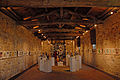
- The Hall of Food ( Halle aux Vivres ) dates back to 1631 and was built in the middle of a large, sparsely developed property in the northeast corner of the citadel. It served the garrison as a provisions magazine for the organization of the procurement, storage and stockpiling of food and for the daily needs of the royal army. The capacity on the first floor was about 720 barrels (tons); on the upper floor there was space for another 300 barrels (tons) with grain, etc. In the superbly restored building with its beautiful brick vaults there is now a European center for military architecture.
- Parallel to the Halle aux vivre and along the steep escarpment of the fortification wall was built in the 1689 cooperage ( Tonnellerie ). Shortly after the building was erected, about half of it had to be demolished as it stood in the way of Vauban's defenses being modified. Food and weapons were traded here, but mainly wooden barrels were made. The barrels were intended for the transport and storage of commercial goods, but above all for gunpowder ( poudre ). In 1826, feed was stored in the building.
- The powder depot Saint-Luc ( Poudrière Saint-Luc ), built in the years 1627–1638, was located in the Saint-Luc bastion in the southwest corner of the citadel. Only the lack of windows made it different from ordinary houses. The house was surrounded by a massive protective wall, the only door was armored. Gunpowder for 60,000 livres could be stored there in barrels. It was very important to Brouage as the powder trade continued to flourish well into the 18th century. The central powder depots in Brouage were intended for the supply of the Royal Army and to replenish the armament of the frigates in the race of nations for the "new lands" overseas.
- The Breche powder depot ( Poudrière de la brèche ) from 1692 was enclosed on three sides by the Bastion de la Breche in the middle of the eastern wall of the citadel and, apart from a small opening, was surrounded by another massive protective wall. Gunpowder for 40,000 livres, equivalent to 20 tons, could be stored here in small barrels on wooden frames. Together with that of Saint-Luc , this powder depot also served to supply the defenses of the Brouage garrison, including their outbuildings, and for the nearby underground ports. The powder depot has been used for cultural purposes since 1910.
- The underground port of the Breche on the east side of the Citadelle ( Port souterrain de la Brèche ) from 1631 was below the urban street level in the northern corner of the Bastion de la Brèche at the foot of the fortification walls. There was a quay just above the former water surface, a landing stage for boats and flat ships. From there one could get into the basement of the bastion and further up through an armored door. The underground port was used for the protected loading and unloading of goods from ships that had to anchor further outside Brouage due to their draft. Mainly powder, food and people were shipped. In this way and with boats the crew of the outworks was also supplied with supplies. The subterranean harbor with its entrance is still well preserved today, but boats no longer moor there, but the cows graze on the pastures of the former marshland ( marais ). The gate, which was closed in the 18th century, was reopened in 1986. There was such a port basement at the southern Bastion d'Hiers .
- The three-aisled church of Saint-Pierre et Saint-Paul in the Renaissance style has hardly changed since its construction; Only the church windows donated by wealthy merchants are more recent. The cemetery that once surrounded the church has now disappeared. In the gable of the church of Brouage there is a classical inspiration of the Renaissance - the coats of arms of St. Timoleon d'Epinay , Luke and his lieutenant Pierre de Comminges , surrounded by the royal arms ( armes royales ).
- In the ramparts on the west and east sides of the citadel there were a total of four public latrines, each with two seven seats in the form of oval cutouts in wooden planks. Here, constantly running water was used to remove excrement and other waste - a particular convenience for the time.
- In the south-east corner of the Richelieu Bastion, one comes across the ice cellar ( glacière ), built in 1688 , a special facility, outwardly in the form of a small wooden building. A conical roof with a lower diameter of 6.10 m rises above the simple square floor plan, with an internal excavation, onto which the gable roof of a small access corridor slides. A local sign explains that this is a facility that cooled ice filled in winter over many months of the warmer seasons and kept it ready for longer preservation of food. Up to 22 barrels of ice could be brought in.
- In the eastern area of the citadel along Rue des Trois Vierges there is a large free plot of land with a fountain in the middle. It is enclosed by a high wall. A sign indicates that members of the troops could be accommodated here, presumably in simple wooden dwellings.
- The barracks ( Anciennes Casernes ) were lined up along the southern fortress wall, and the parade grounds were connected to it as an extension.
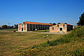
Brouage, Halle aux Vivres and Tonnellerie

Brouage, Halle aux Vivres, exhibition space

Brouage, royal stables, now boutiques

Brouage, Poudrière St.-Luc, with protective wall

Brouage, Saint Pierre
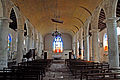
Brouage, Saint Pierre, Interior

Brouage, Rue de Québec, facing south

Brouage, public latrines


Personalities
- Samuel de Champlain was born in Brouage around 1570.
- Maria Mancini , Louis XIV's lover , was temporarily exiled to Brouage in 1659.
literature
- Le Patrimoine des Communes de la Charente-Maritime. Flohic Editions, Volume 1, Paris 2002, ISBN 2-84234-129-5 , pp. 385-393.
- Thorsten Droste: Poitou. Western France between Poitiers and Angoulême - the Atlantic coast from the Loire to the Gironde. DUMONT art travel guide. Cologne 1999, ISBN 3-7701-4456-2 , p. 184.
Web links
- Brouage, Dépliant - photos + brief information (French)
- Brouage - photos + short information (French)
- Brouage - photos + info (French)
Individual evidence
- ↑ Decree of the Prefecture No. 17-2018-11-27-006 on the formation of the Commune nouvelle Marennes-Hiers-Brouage of November 27, 2018.
- ↑ Brouage - map with altitude information
- ↑ Hiers-Brouage - climate tables
- ↑ Remparts in the Base Mérimée of the French Ministry of Culture (French)
- ↑ Église Saint-Pierre-et-Saint-Paul in the Base Mérimée of the French Ministry of Culture (French)
- ↑ Poudrières et casernes in the Base Mérimée of the French Ministry of Culture (French)