IJsselmeer
| IJsselmeer | |
|---|---|

|
|
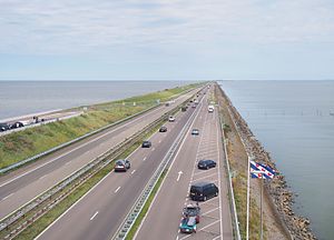
| Closing dike of the IJsselmeer | |
| Geographical location | northern Netherlands |
| Tributaries | IJssel , Zwarte Water , Eem , Hierdensche Beek , Amstel |
| Drain | over two lock groups into the Wadden Sea |
| Places on the shore | Amsterdam , Almere , Edam-Volendam |
| Data | |
| Coordinates | 52 ° 50 ′ 0 ″ N , 5 ° 20 ′ 0 ″ E |
| Depth below sea level | -0.3 m NAP |
| surface | approximately 1137.4 km² |
| volume | 5.232 km³ |
| Maximum depth | 5.5 m |
| Middle deep | 4.6 m |
|
particularities |
originated from the Zuiderzee |

|
|
| Map of the Zuiderzee Works in the Netherlands | |

The IJsselmeer (Eisselmeer, Ysselmeer; [ ˌɛi̯səlˈmeːr ]; the IJ is a ligature in Dutch , which is why the J is written in capitals ) is the largest lake in the Netherlands . Today's freshwater lake, artificially created by dykes , consists of a large part of the former Zuiderzee bay between Friesland and North Holland . The word sea in the Netherlands means “lake”. The lake is named after its main tributary, the (Gelderschen) IJssel ( Gelderse IJssel ), which flows into the Ketelmeer tributary below Kampen . The second largest tributary, the Zwarte Water, flows into the associated lake Zwarte Meer .
history
The IJsselmeer was created in 1932 through the construction of the 29-kilometer-long final dike ( Afsluitdijk ) at the junction of the former Zuiderzee and the Wadden Sea ( Waddenzee ). The dike is 90 meters wide and on the side facing the IJsselmeer it supports the Dutch motorway 7 ( European route 22 ) and its cycle path. It was built as part of the Zuiderzee Works , primarily to protect the coast. Because the tides in the IJsselmeer ceased to exist, water areas could then be more easily diked and drained. This resulted in large polders on the edge of the lake, of which the province of Flevoland is the largest.
The remaining IJsselmeer has, apart from a few artificial depressions, between 2 m and 5.5 m water depth. Since 1976 it has been divided by an inland dike ( Houtribdijk ) into the 1137.4 km² remaining IJsselmeer and, to the southwest of it, the 700.6 km² Markermeer . Two locks at Enkhuizen and Lelystad connect the water bodies. The Markermeer was originally intended to be drained as the Markerwaard polder . Because there was hardly any need for new land, construction was postponed in 1991 for an indefinite period.
When the dike to the North Sea was being built , the Dutch generals recognized the military danger that the fortress of Holland was threatened with this new access from the north. The response was to build the fortresses Den Oever and Kornwerderzand at both ends of the dike . In May 1940, during the attack in World War II , the attacking German Wehrmacht could not gain access to the fortress of Holland at this point.
use
The IJsselmeer is a water sports area and holiday area with touristic places like Hoorn and Enkhuizen .
A wind farm with a total of 86 wind turbines on land and in the water has been built on the coast of the Noordoostpolder in recent years . This near-shore wind farm is part of the Noordoostpolder wind farm , which has produced around 1.4 billion kWh of electrical energy since its completion in 2017 and, with a total output of 429 MW, is one of the largest such plants in the Netherlands.
Cities and villages on the IJsselmeer
(clockwise)
East side of the IJsselmeer:
Located on the Markermeer :
West side of the IJsselmeer:
Inflows and outflows
- Tributaries (from north to south):
- Zwarte Water (lower reaches of the Vechte ), approx. 60 m³ / s
- IJssel (branch of the Rhine ), approx. 390 m³ / s
- Eem (temporarily, otherwise flows over the North Sea Canal ), approx. 10 m³ / s
- Hierdensche Beek (across the Veluwemeer )
- Amstel (temporarily, otherwise flows over the North Sea Canal )
- Vecht (temporarily, otherwise flows over the North Sea Canal )
- Outflows (from north to south):
- Lorentz locks in the final dike (into the Wadden Sea ), approx. 200 m³ / s
- Stevin locks in the final dike (into the Wadden Sea), approx. 250 m³ / s
- IJ and North Sea Canal (temporarily; depending on the control by the Zuiderzeewerke )
Numbers and dates
- Surface: 1137.4 km²
- Deepest point: Val van Urk, 5.50 m
- The water level is kept at 20 cm below NAP in summer and at 40 cm below NAP in winter.
Web links
- Information on the IJsselmeer and other areas in the Netherlands
- Area information on the IJsselmeer on SkipperGuide.de
Individual evidence
- ^ A b Ministry of Infrastructures and Milieu, Ministry of Economics, Zaken, Kadaster, Rijkswaterstaat and Geonovum: Publieke Dienstverlening op de Kaart (PDOK viewer) ; Property information on the location Oppervlaktelichamen - vlakken , accessed on July 29, 2014
- ↑ Note: calculated from area and mean depth
- ↑ a b Paul K. Baggelaar, C. J. van der Meulen (RIWA): Historische en toekomstige ontwikkelingen chloridebelasting in het traject Lobith tot Andijk (PDF; 7.1 MB) , 2009 ISBN 978-90-6683-134-6
- ↑ Noordoostpolder wind farm . Retrieved November 1, 2017.
