
Measure SO
| SO is the abbreviation for the canton of Solothurn in Switzerland and is used to avoid confusion with other entries of the name Messen . |
| measure up | |
|---|---|
 |
|
| State : |
|
| Canton : |
|
| District : | Bucheggberg |
| BFS no. : | 2457 |
| Postal code : | 3254 Balm at Messen 3254 Messen 3307 Brunnenthal 4588 Oberramsern |
| Coordinates : | 600 758 / 215 629 |
| Height : | 505 m above sea level M. |
| Height range : | 464–650 m above sea level M. |
| Area : | 11.89 km² |
| Residents: | 1481 (December 31, 2018) |
| Population density : | 125 inhabitants per km² |
| Website: | www.messen.ch |
 Balm and measure |
|
| Location of the municipality | |
  |
|
Messen is a municipality in the Bucheggberg district in the canton of Solothurn in Switzerland . On January 1, 2010, the merger of the previous municipalities of Balm bei Messen , Brunnenthal , Messen and Oberramsern to form the new municipality of Messen became legally binding.
geography

Messen is at 505 m above sea level. M. , 15 km south-southwest of the canton capital Solothurn (air line). The clustered village extends slightly higher on the southern edge of the Limpachtal , at the foot of the hill zone of Rapperswil, in the Solothurn Mittelland .
The area of the 11.88 km² municipal area comprises a section of the ground moraine landscape of the Rapperswil plateau and the Limpach valley bordering to the north in the extreme southwest of the Solothurn Mittelland. The main part of the area is taken up by the agriculturally intensively used level of the Limpachtal, which in the area of Messen has a width of around two kilometers and averages 470 m. The canalized Limpach runs through the plain in a south-west-north-east direction. The most important tributary in the municipality is the Messibach coming from the south . To the south of the valley level, the municipal ban extends to the heights of the Rapperswil hill country and in Junkholz reaches a height of 563 m above sea level. In the area of Messen, the heights are covered with larger forests (Junkholz, Gsäss, Barhollen and Chräienberg), which are divided by the valleys of Messibach and Länggengraben (valley of the Mülchibach, forms the southeastern municipal boundary). North of the Limpach valley, the slope climbs up to the heights of the Bucheggberg with a wooded, around 150 m high steep step . The highest elevation of masses is 646 m above sea level. M. on the so-called Rapperstübli , the location of the former Balmegg Castle, above Balm. Before the municipal merger, the municipality area of Messen was 7.1 km². 7% of this was settled in 1997, 29% in forests and woodlands, 63% in agriculture and a little less than 1% was unproductive land.
The hamlets of Eichholz ( 483 m above sea level ; the western part of the village is in the Bernese area), Niederwol ( 487 m above sea level ) and Ischbad ( 485 m above sea level ), all slightly elevated on the southern edge, belonged to the old municipality of Messen located on the Limpach plain, as well as some individual farms. Neighboring communities to Messen are Schnottwil , Biezwil , Lüterswil-Gächliwil , Aetigkofen and Unterramsern in the canton of Solothurn and Mülchi , Etzelkofen , Scheunen , Rapperswil (BE) and Wengi in the canton of Bern .
population
With 1,481 inhabitants (as of December 31, 2018), Messen is one of the smaller communities in the canton of Solothurn. 97.6% of the residents are German-speaking, 1.0% French-speaking and 0.3% speak Portuguese (as of 2000, based on the old municipality). The population of Messen was 670 in 1850 and 606 in 1900. During the 20th century, the population always fluctuated between 620 and 690 people. Only since 1980 (670 inhabitants) has there been significant population growth.
economy
Up until the second half of the 20th century, Messen was predominantly an agricultural village. Even today, agriculture and fruit growing, as well as cattle breeding and forestry, have an important place in the income structure of the population. Numerous other jobs are available in local small businesses and in the service sector. Companies in the building trade, information technology, metal construction, two sawmills and a joinery are represented in trade fairs. As the largest municipality in the Limpachtal, Messen has certain central functions for the surrounding area. In the last few decades the village has also developed into a residential community. Many employed people are therefore commuters who work mainly in the Solothurn, Bern and Grenchen regions.
traffic
The community is very well developed in terms of transport. It is located on the main road from Bätterkinden to Lyss . The village is connected to the public transport network by various post bus lines , which serve the routes from Messen to Zollikofen , to Lyss, to Utzenstorf , to Jegenstorf and to the Lohn-Lüterkofen train station, as well as the Bucheggberg on- call bus .
history
The municipality of Messen was already inhabited in Roman times, which was proven by the discovery of wall remains of a villa under the parish church. The place was first mentioned in a document in 1251 under the name Messon ; The current name has been handed down from 1276. The place name goes back to the Latin word mansione (dative from mansio ; German: at the homes).
In the 12th century, measuring was the center of a rule that was a fiefdom of the Counts of Kyburg. The gentlemen of Messen early on concluded a castle rights agreement with Solothurn. Around 1270, the rule of Messen to the monastery Solothurn and from the middle of the 14th century under the rule of the city of Solothurn. In 1410 Messen came under direct Solothurn rule and was assigned to the Bucheggberg Bailiwick. Until 1798 the high level of jurisdiction lay with the Bern district court in Zollikofen , while Messen was one of the four places of jurisdiction in the bailiwick. After the collapse of the Ancien Régime (1798), Messen belonged to the Biberist district during the Helvetic period and to the Bucheggberg district from 1803. The area changed on January 1, 2010, when the previously independent communities of Balm bei Messen, Brunnenthal and Oberramsern were incorporated after Messen.
When drinking water , is looking for a solution as the limit of chlorothalonil is exceeded.
Attractions
The core of the reformed parish church of Saint Mauritius probably dates back to before the year 1000. The church was given its current shape when it was rebuilt around 1480. It has a late Gothic cheese-bite tower made of tuff and a font from 1764.
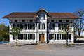
In the old town center there are some stately farmhouses from the 17th to 19th centuries in the Bernese style. The high-rise building at Burggasse 10 was built in 1690/91 and is one of the oldest farmhouses in the Bucheggberg district, the typical stand construction and the two-story smoke kitchen have been restored.
photos

Parish church with parish hall
Primary school building

Schoolhouse Bühl

Restaurant to the lion

Gasthof Sonne

Rectory

former farmhouse


coat of arms
- Two tinned white towers in blue, each with a window, connected by a white gable front with a gate raised by a window
The coat of arms is modeled on that of the gentlemen.
Daughters and sons of the city
- Christian Wanner (* 1947), politician
Web links
- Official website of the municipality of Messen
- Othmar Noser: Messen SO. In: Historical Lexicon of Switzerland .
- Aerial views of the village
Individual evidence
- ↑ Permanent and non-permanent resident population by year, canton, district, municipality, population type and gender (permanent resident population). In: bfs. admin.ch . Federal Statistical Office (FSO), August 31, 2019, accessed on December 22, 2019 .
- ↑ Rahel Meier: Drinking water supply remains an issue at trade fairs. In: solothurnerzeitung.ch . February 3, 2020, accessed February 3, 2020 .
- ↑ Solothurn newspaper of September 9, 2014: European Monument Day
Biezwil |
Buchegg |
Lüsslingen-Nennigkofen |
Lüterkofen-Ichertswil |
Lüterswil-Gächliwil |
Measure |
Schnottwil |
Unterramsern
Former municipalities: Aetigkofen | Aetingen | Balm at trade fairs | Beavers | Brügglen | Brunnenthal | Gächliwil | Gossliwil | Hessigkofen | Ichertswil | Küttigkofen | Kyburg-Buchegg | Lüsslingen | Lueterkofen | Lüterswil | Mühledorf | Nennigkofen | Oberramsern | Tscheppach
Canton of Solothurn | Districts of the Canton of Solothurn | Municipalities of the Canton of Solothurn