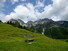
Lammertal
The Lammertal , the valley of the Lammer and its side valleys, is, next to the Salzburg-Halleiner basin , one of the two main settlement areas of the Tennengau ( Hallein district ) in the state of Salzburg . It lies between the Tennengebirge , the Dachstein massif and the Osterhorn group to the north .
In addition to the Lueg Pass, the Lammertal represents the second connection between the Salzburg central area and the Inner Mountains and forms one of the planning regions of the State of Salzburg .
Location, landscape and places
Before it flows into the Salzach, the Lammer river forces its way eastward at Scheffau through a narrow valley about ten kilometers long, the main gorge of which is formed by the Lammeröfen . Behind it the valley widens to the Abtenau Basin , in which the village of Abtenau is located. Here the valley divides, to the east the Rußbachtal extends with the town of Rußbach , where there is a connection to the Inner Salzkammergut via the Gschütt pass and the Gosau valley . The main valley turns south, towards Annaberg , and then south-east, towards Lungötz . The Lammer itself comes from the west, the Tennengebirge. The valley area itself overcomes a valley watershed at Schoberberg , behind which extends the municipality of St. Martin with the Sankt-Martin-Bach , which then flows into Niedernfritz in the Fritztal and thus creates the connection to the Ennspongau . The other side valleys are only sparsely populated.
The Lammertal winds around the floor of the Tennengebirge and thus forms the eastern boundary of the Salzburg Limestone Alps . In the east scenic dominates Gosaukamm with the Bischofsmütze the landscape, while the northern edge of the Limestone Alps of randalpinem , curled-wooded character.
Neighboring regions
Regional planning neighboring regions and mountain groups:
| Salzach-Tennengau (PR) | Osterhorn Group (PR) (RV) (Skg.) | |
| Tennengebirge (TR) |

|
Gosau - Inneres Salzkammergut (Upper Austria) |
| Lower Salzach Pongau (PR) |
Fritztal Enns-Pongau (PR) |
Dachstein massif (D.) |
- (PR)Sbg. Planning region
- (RV)Sbg. Regional association
- (TR)Sbg. Tourist region
- (D.)UNESCO World Heritage Region Hallstatt-Dachstein Salzkammergut , Oberösterr. Lime High Alps spatial unit
Transport and tourism
The main traffic artery is the B 162 Lammertal Straße , which connects to the Tauern Autobahn A 10 / E 55, and the B 166 Pass Gschütt Straße , which also connects to the Tauern Autobahn. In addition, at Abtenau, the Postalm road leads as a high road to Strobl am Wolfgangsee (toll road), and the Trattberg panorama road leads into the Salzach valley above Kuchl .
The whole region is strongly shaped by tourism and, together with the Salzachtal communities above and below the Lueg Pass, forms the Tennengebirge Region Regional Association . The common platform of the Lammertal communities was the Lammertal Dachstein West GmbH tourism region, based in Abtenau. The Lammertal – Dachstein West tourist region was dissolved in 2010 after disputes over the financial settlement between the actual Lammertal and the ski area on the Gschütt Pass .
More than 300 marked hiking trails lead into all three mountain groups, the high-montane karst stock of the Tennengebirge with its southern slate foothills , the Dachstein group with the climbing area Gosaukamm and Bischofsmütze, and the western climbs to the Hohe Dachstein , as well as the Salzkammergut mountains , which are a vast hiking area represent.
- The most important huts in the valley are the Hofpürglhütte on the Bischofsmütze, Gablonzer Hütte to the Gosauseen , the Dr.-Heinrich-Hackel-Hütte on the Tauernscharte of the Tennengebirg-Südabbruch, Laufener Hütte on the high plateau
- The European long-distance hiking trail E4 / Nordalpenweg 01 / Via Alpina ( Violetter Weg, stage A34 / 35), coming from Gosau over the Gosauseen to the Hofpürglhütte, crosses the valley at Lungötz, and leads over the Hackelhütte to Dorfwerfen on the Salzach
- the Salzburger Rundwanderweg Arnoweg ; Section 6 Kalkberge Ost , section 51 Filzmoos – Annaberg, 52 to the Laufener Hütte and 53 to Abtenau, and section 7 Voralpen , section 54 Abtenau– Trattbergalm
For mountain bikers, 720 kilometers are designated as a mountain bike route.
The main winter sports area of the region is Dachstein West on the Hornspitze, which also includes the Gosauer Zwieselalm , other small areas are the Abtenau ski area and the St. Martin am Lammertal ski area , as well as the Postalm near Strobl, which is also part of the Salzkammergut.
literature
- SIR - Salzburg Institute for Spatial Planning & Housing, Tennengau Regional Association (Hrsg.): Tennengau Regional Program . binding by ordinance of the Salzburg state government, LGBl. No. 60/2002. Hallein / Salzburg June 2002 ( short version. In: Regionalplan. Issue 5. Hallein 2002 ( service.salzburg.gv.at )).
Maps:
- f & b 392 Tennengebirge, Lammertal, Gosaukamm. Freytag-Berndt u. Artaria, 1990, ISBN 978-3-85084-739-1 , 1: 25000
Web links
- Homepage of the Lammertal – Dachstein West tourist region
- Homepage of the regional association Tennengau
Individual evidence
- ↑ a b Lammertal . In: Salzburger Nachrichten : Salzburgwiki .
- ↑ Huts in the Lammertal. In: Summer >> Hiking & Trekking. Lammertal – Dachstein West tourism region, archived from the original on September 4, 2011 ; Retrieved March 3, 2010 .
- ↑ Section 6 - Limestone Mountains East. In: The Arnoweg. SalzburgerLand, accessed in 2010 .
- ↑ Section 7 - Pre-Alps. In: The Arnoweg. SalzburgerLand, accessed in 2010 .


