
Strobl
|
Strobl
|
||
|---|---|---|
| coat of arms | Austria map | |
 |
|
|
| Basic data | ||
| Country: | Austria | |
| State : | Salzburg | |
| Political District : | Salzburg area | |
| License plate : | SL | |
| Main town : | Strobl | |
| Surface: | 94.02 km² | |
| Coordinates : | 47 ° 43 ' N , 13 ° 28' E | |
| Height : | 542 m above sea level A. | |
| Residents : | 3,641 (January 1, 2020) | |
| Postal code : | 5350 | |
| Area code : | 06137 | |
| Community code : | 5 03 36 | |
| NUTS region | AT323 | |
| UN / LOCODE | AT STL | |
| Address of the municipal administration: |
Dorfplatz 1 5350 Strobl |
|
| Website: | ||
| politics | ||
| Mayor : | Josef Weikinger ( ÖVP ) | |
|
Municipal Council : (2019) (21 members) |
||
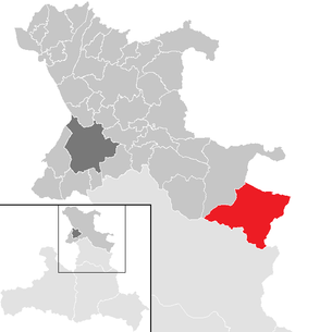
| Location of Strobl in the Salzburg-Umgebung district | ||
  |
||
 West view of Strobl |
||
| Source: Municipal data from Statistics Austria | ||

Strobl is a municipality in the Salzburg-Umgebung district in the State of Salzburg in Austria . The district administration is in the city of Salzburg , the district court Thalgau is responsible for the 3641 inhabitants (as of January 1, 2020) .
geography


The community is located in Flachgau on Lake Wolfgang in the Salzburger Salzkammergut . The community occupies the middle right side of the Wolfgang Valley, with the south-east bank of the lake from the Zinkenbach ( Zinkenbach peninsula ) to the Bürgl [stein] ( 745 m above sea level ), and south of the upper Ischler Ache (also Ischl ) . The most important side valley is the Weißenbachtal with the Postalm , which stretches into the Osterhorn group of the Salzburg pre-Alps and the Salzkammergut mountains .
Due to its sunny location on the wide, flat eastern shore of Lake Wolfgang, Strobl has beautiful natural beaches with relatively high water temperatures.
Community structure
The municipal area includes the following four cadastral communities and localities (area 2016; population as of January 1, 2020):
- in the west: Gschwendt (3,384.15 ha, 600 Ew.) - on the Zinkenbach peninsula of the Wolfgangsee
- in the center: Strobl (942.04 ha, 1371 Ew., main town) - at the east end of the Wolfgangsee at the foot of the Bürglstein
- in the south: Weißenbach (KG Weissenbach 2,317.27 ha, 823 Ew.) - at the entrance of the Weißenbach valley
- in the east: Aigen (2,744.83 ha, 847 Ew.) - right bank of the Ischl
Counting districts are Strobl for the main town and Strobl-Umgebung for the rest of the community.
Strobl belongs to the LEADER / INTERREG region cultural heritage (Inneres) Salzkammergut (REGIS). Tourism Economically cooperates with the community of St. Gilgen and the Upper Austria St. Wolfgang in the tourist region of Holiday region Lake Wolfgang ( Wolfgangsee tourism company WTG) as part of the composite Salzkammergut .
Neighboring communities
history
The name "Strobl" means a messy man and goes back to the 14th century. Back when the Wolfgangsee was still called Abersee, a certain Friedrich Stroblo appears as the first owner of a "Seege" (= fish pond).
160 years later, the "Strobls" own a property on Am Schober and form the core of the emerging town of Strobl. The place name Strobl was first used in documents in 1593, but it did not become generally accepted until the 19th century. The place name goes to Hanns III. Strobl, who was bailiff and tavern keeper at the place around 1587. The Strobl family was the local leader until 1765. Under the married-in successor Joseph Sigmund Berchtold and Sonnenburg, the property of the Strobl family disintegrated, but the name "Strobl" had become naturalized for the area around the old Am Schober tavern.
At the time when the old property was dismembered and the tavern rights were transferred from the old Strobl inn, the Platzlhof was built around 1800 . It became the post office and was the station of the Thurn and Taxic Post Line . It experienced a heyday from 1877 to 1890 when, in addition to the flourishing mail car traffic, the fiakers brought their guests from the imperial Bad Ischl to the Wolfgangsee.
In 1890 Strobl was connected to the Ischlerbahn (Salzkammergut-Lokalbahn, SLKB) to Bad Ischl (opening August 5th), which resulted in a further increase in day-trippers due to its easy accessibility. The connection to Salzburg via St. Gilgen and Mondsee was not completed until 1893 (opening June 20). This was the beginning of the first phase of local development. The railway operated until 1957 and was then sacrificed for road expansion.
At the turn of the century in 1900, Strobl became the country residence of Baron von Gecmen-Waldeck. The family had become very wealthy through industrialization. In Vienna she owned a grand palace in Hietzing and large estates in Bohemia . During the summer stays of Emperor Franz Joseph I in Bad Ischl, the Strobler property was a meeting point for prominent social events. Here the high aristocracy and the upper classes frequented.
After the Second World War , tourism began a new phase of development in the 1960s. The Kurhotel Schloss Strobl was built on part of the Gecmen-Waldeck property . The old structure was fully preserved and renovated and blends in harmoniously with the modern use. In the Osterhorn Mountains, the Postalm is a well-visited family ski area . The main economic factor is still the summer swimming season at the lake.
coat of arms
The coat of arms of the municipality is described :
- “In a silver shield, a transverse, gold-tied blue bundle with pig iron rods, growing behind it a forward-looking man with a black goatee and" tousled "hair, covered with a broad-rimmed green beret, adorned with two black cock feathers on the back, a stiff silver ruff, clad in a blue doublet and sleeveless green overskirt, with a gold fur collar and two gold buttons, holding a black judge's staff in the right hand, the left hand on the iron bundle. "
politics
The community council has a total of 21 members.
- With the municipal council and mayoral elections in Salzburg in 2004, the municipal council had the following distribution: 11 ÖVP, 8 SPÖ, and 2 FPÖ.
- With the municipal council and mayoral elections in Salzburg in 2009 , the municipal council had the following distribution: 13 ÖVP, 6 SPÖ, and 2 FPÖ.
- With the municipal council and mayoral elections in Salzburg in 2014 , the municipal council had the following distribution: 11 ÖVP, 5 SPÖ, 3 GRÜNE, and 3 FPÖ.
- With the municipal council and mayoral elections in Salzburg in 2019 , the municipal council has the following distribution: 13 ÖVP, 5 SPÖ, 2 GRÜNE, and 1 FPÖ.
- mayor
- 1954–1974 Michael Laimer
- 1974–1982 Hans Stehrer
- 1982-2004 Franz Unterberger (ÖVP)
- since 2004 Josef Weikinger (ÖVP)
Capital of the municipality
|
Strobl ( village ) locality ( capital of the municipality ) cadastral municipality Strobl |
|
|---|---|
| Basic data | |
| Pole. District , state | Salzburg area (SL), Salzburg |
| Judicial district | Thalgau |
| Pole. local community | Strobl |
| Coordinates | 47 ° 43 ′ 8 " N , 13 ° 28 ′ 58" E |
| height | 542 m above sea level A. |
| Residents of the village | 1371 (January 1, 2020) |
| Building status | 400 (2001 ) |
| Area d. KG | 9.42 km² |
| Post Code | 5350 Strobl |
| Statistical identification | |
| Locality code | 13930 |
| Cadastral parish number | 56108 |
| Counting district / district | Strobl (50336 000) |
 Strobl, view over Lake Wolfgangtal outwards (eastwards, to Ischl) |
|
| Source: STAT : index of places ; BEV : GEONAM ; SAGIS | |
The municipality's capital is the town and cadastral municipality of Strobl .
The village is located 34 km east of Salzburg and 10 km west of Bad Ischl . It is located on the eastern shore of Lake Wolfgang , 4 km southeast of St. Wolfgang , at around 542 m above sea level. A. Altitude (the lake is 538 m above sea level ). It extends from the outflow of the Ischler Ache at the foot of the Bürgels (also Bürglstein, 745 m above sea level ) to Wolfgangsee Strasse B 158 and includes around 350 addresses. To the west of the village lies the lake Marienhof on the Marien peninsula , to the east behind St. Wolfganger Straße ( L 116 ) the Parkvillage Seethurn .
The cadastral community with 94.02 km² extends over 5 km southwest into the Osterhorn group . This also includes the houses Am Urschlag and the scattered houses Haberg on the right in the Wolfgangtal . Here the small valley of the Moosbach stretches southwards, the borders form the Bleckwand ( 1541 m above sea level ) and the characteristic Sparber ( 1502 m above sea level ). There is the Schartenalm .
The village of Strobl has around 400 houses with 1,372 inhabitants (January 1, 2017).
Significant sights are the parish church of St. Sigismund and several houses from the Wilhelminian era ( Deutschvilla , Lederervilla , Marienhof ).
The place has a lake promenade, a public seaside swimming pool and a ship landing stage . The Blinklingmoos nature reserve is located directly to the west of the village .
|
Wolfgangsee |
St. Wolfgang in the Salzkammergut (KG) Bürglstein (O) |
Mönichsreith ∗ (Gem. St. Wolfgang i.Skg. , District Gmunden , Upper Austria) |
.svg)
|
Aigen (O & KG)
|
|
|
Haberg (O and KG Strobl)
|
Weißenbach (O and KG) ∗
|
 |
Village Strobl, in the back Rettenkogel , Rinnkogel and the Gupf des Sparber , the mountains at the Weißenbachtal (view over the lake from St. Wolfgang to the southeast) |
economy

Strobl is a tourist resort that benefits from its location on Lake Wolfgang . In 2003 there were 228,950 overnight stays with 2,194 guest beds. Together with the Wolfgangsee communities of St. Gilgen and St. Wolfgang, the Wolfgangsee Tourismus Gesellschaft (WTG) was founded in 1998 for the purpose of tourism marketing for the three communities on the Wolfgangsee.
The Postalm , the second largest alpine pasture in Central Europe, is located at an altitude of 1300 meters . The high plateau is a summer recreation area and ski area - this is already in the Abtenau part of the Postalm.
Culture and sights

- Catholic parish church Strobl hl. Sigismund
- Deutschvilla : built in 1896, expanded in Art Nouveau style in 1923/24. The villa was confiscated and expropriated in 1938 during the National Socialist era; it was used for 30 years as a boarding house to accommodate participants of the summer university in the St. Wolfgang district of Bürglstein and was temporarily threatened with demolition. It is currently a cultural center.
- Lederervilla: neo-baroque castle built in 1899.
- Marienhof: Villa built in the Tuscan style in 1907. Also threatened with demolition.
- Works by Toni Schneider-Manzell , Ilse Sprohar and Eva Mazzucco can be found on the Kulturpromenade .
- Regular events
- International Literature Academy Salzkammergut: from the Strobl Literature Days, which have been held every summer in Strobl since 1999, the International Literature Academy Salzkammergut emerged in 2005
- Summer college of the University of Vienna in the Deutschvilla
- Polo event Strobl, annual amateur polo tournament in August
- Annual conference of Latin America Research Austria , since 1985 in the Federal Institute for Adult Education (BIFEB)
traffic
- The main traffic axis is the B 158 Wolfgangsee Straße from Salzburg to Bad Ischl , at Weißenbach and Strobl the short L 116 / L 546 St. Wolfganger Straße branches off to St. Wolfgang.
- The nearest national train station is in Salzburg (45 km) or regionally in Bad Ischl (12 km).
- There is a bus connection to St. Gilgen (connection to Salzburg), Bad Ischl and St. Wolfgang . The Postalm can be reached via the toll Postalmstraße from Strobl towards Abtenau ( Lienbachsattel ); there is also a post bus connection from Strobl.
- Strobl is also the landing stage for the Wolfgangsee shipping company , which is operated today by Salzburg AG in conjunction with the Schafbergbahn .
education
- The Deutschvilla , which served the Viennese Deutsch family as a summer residence from 1924, is a cultural center .
Personalities

Honorary citizen of the community
- 1912 Eduard Graf von Paar , adjutant general of Emperor Franz Joseph I.
- 1930 Anton Eisl von Eiselberg , Hofrat
- 1931 Gustav Reuter, Councilor
- Franz Xaver Seitz, pastor
- 1946 Johann Baumgartner, hotel owner (Grandhotel)
- Adalbert Lederer
- Franz Schenner
- At the request of the district captain Dworschak, also appointed honorary citizens in 1946:
- Franz Rehrl , last governor before the war
- Mark W. Clark , then US High Commissioner for Austria
- Harry J. Collins , at that time commander of the US troops in Austria
- Edgar Heine (Hume), then US military governor for Austria
- Elmar H. Braun
- 1951 Matthias Daxinger, member of the municipal council
- 1955 Maximilian Hechenblaikner, pastor
- 1994 Michael Laimer, former mayor
- 2005 Franz Unterberger, former mayor
Sons and daughters of the church
- Vinzenz Maria Süß (* 1802 Weißenbach near Strobl; † 1868 Salzburg), founder of the Salzburg Museum Carolino Augusteum
- Josef Freiherr Lasser von Zollheim (* 1814 Weißenbach near Strobl, † 1879 Vienna), Ministerialrat and Minister of the Interior
- Karl Loidl (* 1893 Strobl; † 1965), member of the Upper Austrian Landtag
- Karl Gitzoller (* 1905 Strobl; † 2002 Neuhaus an der Triesting), resistance fighter
- Leopold Engleitner (* 1905 Aigen-Voglhub; † 2013 Puchenau), Austrian Nazi victim
- Matthias Hödlmoser (* 1907 in Strobl; † 1981 in Vöcklabruck), farmer and politician, knight of the Holy Sepulcher in Jerusalem
- Benno Wintersteller (* 1940 in Strobl; † 2018 in Wels), Benedictine of the Kremsmünster Abbey and literary scholar
- Eva Mazzucco (* 1925 in Strobl; † 2013 in Salzburg), sculptor and graphic artist
- Ferdinand Götz (* 1955 Strobl), artist
People related to the community
- Emil Jannings (* 1884 Rorschach; † 1950 Strobl), German actor and first winner of the Oscars / Best Actor
- Tassilo Fürst von Fürstenberg (* 1903 Brussels; † 1987 Strobl), nobleman from the Fürstenberg family
- Hugo von Hofmannsthal had chosen Strobl as a retreat in the 1870s.
- Theo Lingen often spent his summers in Strobl, but was not, as is often assumed, mayor of Strobl for a few days in 1945.
- The actor Emil Jannings already had a country house in Strobl from 1929, moved to Strobl in 1945 and died here in 1950.
- Leopold , King of Belgium , and his family were interned in Strobl at the beginning of 1945, accompanied by 200 people from the Waffen SS , until he was liberated by the US Army in May 1945 and stayed until 1950.
- In 1973 Hildegard Knef temporarily moved into the Hubertushof hunting lodge (the country house of Prince von Fürstenberg ) in Strobl.
- Chamber actress Helene Thimig-Reinhardt , the wife of Max Reinhardt , lived in Strobl for more than 20 years - a bust on the lake promenade commemorates her.
Web links
- 50336 - Strobl. Community data, Statistics Austria .
- www.strobl.salzburg.at , website of the municipality
- Strobl . In: Salzburger Nachrichten : Salzburgwiki .
Individual evidence
- ↑ Federal Office for Metrology and Surveying, Regional Information, reference date December 31, 2016, accessed February 19, 2017
- ↑ Statistics Austria: Population on January 1st, 2020 by locality (area status on January 1st, 2020) , ( CSV )
- ↑ What is REGIS, regis.or.at.
- ↑ Michael Laimer . In: Salzburger Nachrichten : Salzburgwiki .
- ↑ Hans Stehrer . In: Salzburger Nachrichten : Salzburgwiki .
- ^ Franz Unterberger . In: Salzburger Nachrichten : Salzburgwiki .
- ↑ Josef Weikinger . In: Salzburger Nachrichten : Salzburgwiki .
- ↑ Federal Office for Metrology and Surveying, Regional Information, reference date December 31, 2016, accessed February 19, 2017
- ↑ a b c Dispute over villa near nature reserve. salzburg.ORF.at, August 4, 2013,
- ↑ a b wayside shrine at Marienhof. marterl.at (accessed April 3, 2017).
- ^ Website of Latin America Research Austria
- ↑ Wolfgangsee shipping. schafbergbahn.at.
- ↑ Harry J. Collins . In: Salzburger Nachrichten: Salzburgwiki .
- ↑ Edgar Erskine Hume . In: Salzburger Nachrichten: Salzburgwiki .

Anif | Anthering | Bergheim | Berndorf near Salzburg | Bürmoos | Dorfbeuern | Ebenau | Elixhausen | Elsbethen | Eugendorf | Faistenau | Fuschl am See | Göming | Grödig | Großgmain | Hallwang | Henndorf am Wallersee | Hintersee | Court near Salzburg | Coupling | Köstendorf | Lamprechtshausen | Mattsee | Neumarkt am Wallersee | Nussdorf | Oberndorf near Salzburg | Obertrum am See | Plainfeld | Sankt Georgen near Salzburg | Sankt Gilgen | Schleedorf | Seeham | Seekirchen am Wallersee | Straßwalchen | Strobl | Thalgau | Wals-Siezenheim
Cadastral communities and localities: Aigen | Gschwendt | Strobl | Weissenbach
Villages: Strobl • Rotten: Aigen | Forest lift | Gschwendt | Weißenbach • Settlements: Seethurn • Scattered houses: Haberg | Postalm • Other locations: Abersee | Bleckwandhütte | Egg | Rettenkogelhütte | Vitz am Berg | Watch
Counting district: Strobl | Strobl area
