
Wolfgangsee
|
Wolfgangsee Abersee |
||
|---|---|---|

|
||
| Wolfgangsee from the southeast. In the background the Schafberg | ||
| Geographical location | Salzkammergut | |
| Tributaries | Zinkenbach, Kesselbach, Kohlbach | |
| Drain | Ischler Ache / Ischl → Traun → Danube → Black Sea | |
| Islands | Butcher island | |
| Places on the shore | St. Wolfgang , St. Gilgen , Strobl | |
| Data | ||
| Coordinates | 47 ° 45 ' N , 13 ° 24' E | |
|
||
| Altitude above sea level | 538 m above sea level A. | |
| surface | 12.84 km² | |
| length | 10.3 km | |
| width | 2 km | |
| volume | 667.07 million m³ | |
| Maximum depth | 114 m | |
| Middle deep | 52 m | |
| Catchment area | 124.8 km² | |

The Wolfgangsee , with its older name also Abersee , is a lake in Austria . It is mostly located in the northeast of the federal state of Salzburg , a small part belongs to Upper Austria , and with 13 km² it is one of the largest and most famous lakes in the Salzkammergut region . The Salzburg municipalities of Sankt Gilgen and Strobl and the Upper Austrian municipality of Sankt Wolfgang in the Salzkammergut are located on Lake Wolfgang . The area around Lake Wolfgang is a much-visited tourist region ( Wolfgangsee holiday region ).
Naming
The original name of the lake is Abersee , in older spelling also Äbersee and in similar variants can be found. The first written document comes with " ad Abriani Lacu " ( lat. , At Abriansee ') from the year 788. A Celtic origin of the word part superstition is excluded, and passing the name of the lake on a person with the Old High German name Aparin back who exercised fishing rights here and / or owned land (the same motif is also assumed for some other lakes in the near and far surroundings). It could also have just been the name of the eastern part - interpreted as an independent "Untersee" - St. Gilgen was originally called Oberdrum , a name similar to the three Trumer Lakes in the Salzburg Lake District.
The lake was named after the town of St. Wolfgang for the first time with “Wolfgangersee” in 1381, but it remained an exception for a long time. The name after the settlement also found its way into the first maps of the 16th and 17th centuries, but the final displacement of the name "Abersee" by "Wolfgangsee" is only attributed to the rapidly increasing tourism in the area after the Second World War. Today the Wolfgangsee is only rarely called “Abersee”.
The name "Abersee" had been carried over to the entire area around the lake over time. In 1599, for example, St. Wolfgang is spoken of as "in the Aberseeischen Gebürg [= mountains]". A settlement by the lake, Zinkenbach (after the stream of the same name ), received this name, the part of the municipality of St. Gilgen , now called Abersee , and the part of the municipality of Strobl.
A popular explanation of the name "Abersee" stems from the view that the lake seldom closes in unusually cold winters, so it remains colloquially aperous in normal winters. “Abersee” cannot be linguistically associated with the word “ aper ”, especially since it also means “free of snow” and not “free of ice” (in the sense of ice made from frozen water). In addition, comparatively more frequent freezing of other lakes cannot be proven. This misconception was spread in a folklore work by the lawyer and local researcher August Prinzinger the Elder. Ä. from 1890.
geography


The Wolfgangsee has an area of 13 km². It lies at an altitude of 538 meters and is 114 meters deep at its deepest point. It is divided into two lake basins by the alluvial cone of the Zinkenbach from the Osterhorn group , the Zinkenbach peninsula on the south bank, and the smaller alluvial funnel of the Dillbach from the Schafberg . At this point the lake is only a good 200 meters wide and 20 m deep. The Zinkenbach is the main inflow of the Wolfgangsee, the outflow is via the Ischler Ache (Ischl) at the eastern end. The mean discharge (MQ) is 5.4 m³ / s, the (theoretical) water renewal time 3.9 years.
The neighboring places, St. Gilgen , Strobl , Abersee and Ried are located in the Salzburg area; only St. Wolfgang is in Upper Austria.
As a connection from St. Wolfgang to St. Gilgen on the north side of the lake there is only a footpath over the elevation of the Falkenstein .
The only island in Lake Wolfgang is the tiny butcher island with the ox cross .
geology
The lake was created by the erosion activity of the Traungletscher. At the north-western and south-eastern ends of the lake there is an extensive moraine area that also lines the lake basin. Due to the closure of the glacier, the lake level in the early late glacial was originally around 600 m. For the time around 18,500 BC. A late glacial lake level of 544 m was detected, with which the current level of 538 m has already been largely reached. The introduction of bed load from the Zinkenbach resulted in a transformation of the uniformly shaped lake basin, which divided the 2 km wide lake into two basins by this narrowing to around 250 m. The lake was always drained via the Ischl valley furrow . A connection with the Fuschlsee or the drainage over the Mondsee can be excluded.
The Wolfgangsee is framed on the southwest side by the gently crumbling Gosau layers of marl, sandstone and conglomerate, on the northeast side mainly by the Lias, Hierlatz and Thitonic Plassen limestone of the Schafberg.
tourism


The main source of income for the local population is tourism; There are currently 8,500 guest beds in the three Wolfgangsee villages, which means that around 900,000 overnight stays are achieved each year. Around 75% of the overnight stays are in the summer season. In 1998 the communities Strobl, St. Gilgen and St. Wolfgang merged to form a common tourism organization, the Wolfgangsee Tourismus Gesellschaft mbh (WTG). This represents the tourist region Ferienregion Wolfgangsee and is also a member of the Salzkammergut municipal association (also organized as a GmbH). In 1990 there were 1,300,000 overnight stays at Lake Wolfgang, in 2015 there were 885,214 overnight stays and in 2016 917,929 overnight stays according to the annual report of the WTG. Hans Wieser has been managing director of WTG since it was founded.
There has been shipping and ferry traffic on Lake Wolfgang for a long time. Today, liner shipping is operated in the summer months as well as in the run-up to Christmas. The Wolfgangsee-Schifffahrt was, like the Schafbergbahn starting from St. Wolfgang, part of the Austrian Federal Railway until 2005 and was then spun off. Both are now operated by the Salzkammergutbahn GmbH , whose shareholder is almost 100% the Salzburg infrastructure company Salzburg AG . In addition to the regular service, which is mainly used for excursions, various special trips are also offered. In addition, there is a ferry for pedestrians and cyclists that is independent of the shipping company between St. Wolfgang and Abersee. For hikers there is a signposted, around 27 km long loop around the lake.
Due to its high water quality, the Wolfgangsee has been named a reference body of water by the European Union. Among other things, the pearl fish is native here, which is only found in some of the very clean Salzkammergut lakes and Slovakia. The lake is classified as oligotrophic , the visibility depth is 10.3 m.
The lake is also an excellent diving area because of its mostly year-round very clear water . Divers find a bizarre underwater landscape with sunken trees at the Franzosenschanze . Immediately in front of the Fürbergbucht , challenging dives can be made to the underwater part of the Falkensteinwand, and in front of the naval school in St. Gilgen there are artifacts from the time of the Second World War on the lake bed.
The Falkensteinwand has been a climbing wall and meeting place for cliff divers for many years . With a jump height of up to 28 m, the Falkensteinwand is one of the world's highest cliffs from which one can jump.
Surrounding places

- Abersee : The place is part of St. Gilgen, it is located in the southern center of the Wolfgangsee and is divided by the Zinkenbach. The place is known for the Zinkenbach painters' colony that used to be located there .
- Fürberg is a part of St. Gilgen on the northeastern bank of the lake. In this area there are bathing places, restaurants, the direct starting point of the footpath over the Falkenstein to Ried as well as a stop of the Wolfgangsee-Schifffahrt.
- Ried is part of the municipality of St. Gilgen, which is separated from the main town by the Falkensteinwand. It can only be reached on the road around the lake via St. Wolfgang. The castle-like main building of the Ferienhort am Wolfgangsee , an association dedicated to child welfare , was built in 1902 and can be seen from afar .
- St. Gilgen : The community is known as the vacation spot of the German Chancellor Helmut Kohl and as the residence of Anna Maria Mozart , the mother of the composer Wolfgang Amadeus . The community has been Salzburg's “foot in the door” to the Salzkammergut since the Middle Ages. Like Strobl, the place experienced its first heyday as a summer resort in the period after the Second World War.
- St. Wolfgang : The place is named after St. Wolfgang , who, according to legend, threw an ax and built a church on the spot where it landed. The community at the foot of the Schafberg became a place of pilgrimage and was the most important place of pilgrimage in Central Europe in the Middle Ages. The church, built in the Gothic style, houses a well-known winged altar carved by Michael Pacher .
- Strobl : The community is home to numerous artists, authors and actors. There are still a number of country villas from the imperial era in the village.
photos

Excursion ship MS Austria in front of St. Wolfgang

Falkenstein wall
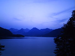
Wolfgangsee in the evening

Resort

View of St. Wolfgang


.JPG)


literature
- Willi Senft, Hilde Senft: The most beautiful lakes in Austria. Leopold Stocker Verlag, Graz 2005, ISBN 3-7020-1089-0 , p. OA
Web links
- Entry on Wolfgangsee in the Austria Forum (in the Heimatlexikon)
- Tourism website wolfgangsee.at
- Pictures from Lake Wolfgang and the surrounding communities on salzburgnet.com
Individual evidence
- ↑ a b c d e f g h i Federal Office for Water Management (Ed.): Atlas of Austria's natural lakes with an area ≥ 50 ha. Morphometry - typing - trophy. As of 2005. Series of publications by the Federal Office for Water Management, Volume 29, Vienna 2008, pp. 81–83 (PDF; 9.0 MB)
-
↑ For the history of the name cf. Leopold Ziller: Aberseer name book. Hall, house and family names of the judicial district of St. Gilgen. Edited and published by the Raiffeisenkasse St. Gilgen, Fuschl, Strobl, St. Gilgen / Fuschl / Strobl 1977, p. 12 f;
Franz Hörburger : Salzburg place name book. Edited by Ingo Reiffenstein and Leopold Ziller, ed. by the Society for Salzburg Regional Studies , Salzburg 1982, p. 154. - ↑ Ziller: Aberseer name book. , P. 13. - Two works by Prinzinger from 1890 are cited in the sources, but it is not mentioned in which of these two publications Prinzinger's view is represented. It is probably about the work on naming and folklore of the Alps , since this topic is not dealt with in the other work mentioned, Zur altsalzburgischen Geographie (online at anno.onb.at ).
- ^ Company Wolfgangsee Tourismus Gesellschaft mbH in St. Wolfgang . Commercial register data Creditreform / firmenabc.at
- ↑ Diving. wolfgangsee.at, accessed on April 8, 2012

Almsee | Altausseer See | Attersee | Augstsee | Dreibrüdersee | Egelsee | Elmsee | Fuschlsee | Gosau Lakes | Great Bad Sea | Großsee | Grundlsee | Hallstätter See | Lake Henar | Hinterer Lahngangsee | Hintersee | Hirzkarseelein | Irrsee | Kammersee | Little Bad Sea | Koppenwinkel lacquers | Krallersee | Langbathseen | Laudachsee | Fairytale lake | Mondsee | Nut Lake | Offensee | Ödensee | Ostersee | Salza reservoir | Schwarzensee (St. Wolfgang) | Schwarzensee (Tauplitz) | Sommersbergsee | Steirersee | Taferlklaussee | Tauplitzsee | Toplitzsee | Traunsee | Vorderer Lahngangsee | Wildensee | Wolfgangsee