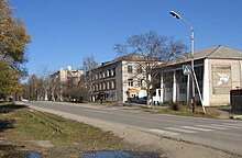
Laso (Primorye, Lasowski)
| Village
Laso
Лазо
|
||||||||||||||||||||||||||||||||
|
||||||||||||||||||||||||||||||||
|
||||||||||||||||||||||||||||||||
Laso ( Russian Лазо́ ) is a village (selo) in the Primorye region in Russia with 3434 inhabitants (as of October 14, 2010).
geography
The place is about 170 km as the crow flies east of the regional administration center Vladivostok in the southern part of the Sichote-Alin , a good 40 km from the coast of the Sea of Japan . It is located at the confluence of the Lasowka (formerly Wangou ) and the Passetschnaja (Konchesa) in the Kijewka (Sudsuche), which flows 60 km south-southwest of the Sea of Japan.
Laso is the administrative center of the Rajons Lasowski and seat of the rural community Lasowskoje selskoje posselenije, (30 km northwest) (12 km east) are among the also the villages Kischinjowka (13 km south), Seljony and Staraya Kamenka.
The administration of the over 800 km² large national park Sow Tigra ("Call of the Tiger "), founded in 2007, is located in Laso . It extends northeast of the village in the upper reaches of the Ussuri , up to about 40 km from the place distant mountain Oblatschnaja, which with 1,854 meters the highest peak of the southern Sikhote-Alin and second highest mountain in the Primorye Territory.
history
The village was founded in 1907 by resettlers from the Bryansk and Chernigov governorates as Monomachowa Slobodka . In 1933 it was named Wangou after the river, today's Lasowka. On March 4, 1941 the place came to the newly formed Sokolowski rajon with its seat in the 50 km south on the coast village Sokolowka (today part of the settlement Preobrashenije ). As early as May 8, 1943, the administrative headquarters were relocated to the village of Sudsuche not far from the mouth of the river of the same name (today the place and river are called Kijewka ), but the Rajon name was retained for the time being. Since August 26, 1949, the Rajon administration is located in Laso, which at the same time received this name after the revolutionary Sergei Laso (1894–1920) who was active in the Far East of Russia , as did the Rajon.
Population development
| year | Residents |
|---|---|
| 1959 | 1482 |
| 1970 | 2020 |
| 1979 | 3105 |
| 1989 | 3864 |
| 2002 | 3638 |
| 2010 | 3434 |
Note: census data
traffic
The village is situated on the regional road 05N-131 (formerly R447) which km southwest to the about 100 Nakhodka starts and further from Laso on the northeast neighboring Rajonzentrum Olga until its confluence with the 05N-100 (formerly A181) at kavalerovo runs. The nearest train station can be reached via this road in Partisansk, almost 70 km southwest on the Trans-Siberian branch line to Nakhodka.
The 05K-451/452 (formerly R448) runs from Laso down the Kijewka to almost the mouth and further along the coast to Preobraschenije. To the north, the mostly unpaved 05K-414 leads to almost 90 km away Tschugujewka and also for little north of it running past 05N-100.
Web links
- Lasovsky rajon on the official website of the Oblast Administration (Russian)
Individual evidence
- ↑ a b Itogi Vserossijskoj perepisi naselenija 2010 goda. Tom 1. Čislennostʹ i razmeščenie naselenija (Results of the All-Russian Census 2010. Volume 1. Number and distribution of the population). Tables 5 , pp. 12-209; 11 , pp. 312–979 (download from the website of the Federal Service for State Statistics of the Russian Federation)


