
Lavrentija
| Village
lavrentiya
Лаврентия
|
||||||||||||||||||||||||||||||
|
||||||||||||||||||||||||||||||
|
||||||||||||||||||||||||||||||


Lavrentija ( Russian Лавре́нтия ) is a village with 1,459 inhabitants (as of October 14, 2010) in the northeastern part of the Chukchi Autonomous Okrug in the far east of Russia .
geography
The village is located on the Chukchi Peninsula on the southwest side of the bay of the same name on the Bering Strait , about 600 kilometers northeast of the district administrative center of Anadyr .
Lavrentija is the administrative center of the easternmost part of Russia's Chukotsky Rajons .
Most of the inhabitants of Lavrentija and Rajon are Chukchi , as well as members of the Eskimo tribe Yupik , who speak the Naukan language in this area .
history
The village was founded in 1933 in place of an older Chukchi settlement as the center of the Rajon founded in 1927 and as part of the collectivization of reindeer herding as a "cultural base" (Russian Kultbasa ) and named after the bay. Its name (Russian Saliw Swjatowo Lavrentija , English Bay of Saint Lawrence ) refers to the Christian martyr Laurentius of Rome (Russian Lavrenti ) , as does the Saint Lawrence Island , which belongs to the United States and is not far from the Bering Strait . The bay got its name - in contrast to the island named by Vitus Bering in 1728 - exactly 50 years later from James Cook , who reached it on his third Pacific voyage on August 10, 1778, the 1500th anniversary of the death of St. Lawrence.
The village developed particularly in connection with an airport located here, which was used, among other things, to transfer American lend-lease aircraft to the Soviet Union during World War II , and from 1953 for civilian purposes as well.
Population development
| year | Residents |
|---|---|
| 1959 | 809 |
| 1970 | 1702 |
| 1979 | 2369 |
| 1989 | 3012 |
| 2002 | 1333 |
| 2010 | 1459 |
Note: census data
Culture and sights
The village has a small local museum.
Economy and Infrastructure
Practically the only branch of industry in the Rajons is reindeer herding carried out by members of the indigenous peoples; one of the centers is located next to small supply and repair companies in Lavrentija.
Lavrentija has a small seaport and an airport in the middle of the town ( Saliv Lavrentija , Lavrentija Bay , ICAO code UHML ), from which there is a flight connection to Anadyr. Lavrentija is connected to the village of Lorino , further west on the coast, via a 40 km long gravel road . The last missing larger bridges along this route over the rivers Loren, Kukun and Tschulchewejem (Bolshaya Akkani) were built between 2009 and 2011.
Photo gallery

Lavrentija (Chukotka),
Lavrentija Bay on the Bering Strait
Lavrentija (Chukutka),
town center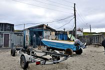
Lavrentija (Chukutka),
fishermen's huts
Lavrentija (Chukutka),
festival scenes


Individual evidence
- ↑ a b Čislennostʹ naselenija gorodskich naselennych dotov, selʹskich naselennych dotov po Čukotskomu avtonomnomu okrugu. (Population of urban settlements, rural settlements in the Chukchi Autonomous Okrug.) Download from the website of the Chukchi Autonomous Okrug of the Federal Service of State Statistics of the Russian Federation
- ↑ Naukan language at Ethnologue (English)
- ^ Andrew Kippis: Narrative of the Voyages Round The World, Performed by Captain James Cook . London 1788 (Chapter 6, online ).
- ↑ Lavrentija on the website of the RAN Geographical Institute (Russian)
Web links
- Chukotsky Raion on the Autonomous Okrug Administration website (in Russian)
| Cities | |||||||
| Urban-type settlements |
Beringowski SG | Egwekinot S | Mys Schmidta | Providenia S | Ugolnye Kopi SG |
||||||
| More parish seats |
|
||||||
|
Other inhabited places in urban districts |