Le May-sur-Èvre
| Le May-sur-Èvre | ||
|---|---|---|
|
|
||
| region | Pays de la Loire | |
| Department | Maine-et-Loire | |
| Arrondissement | Cholet | |
| Canton | Saint-Macaire-en-Mauges | |
| Community association | Agglomération du Choletais | |
| Coordinates | 47 ° 15 ′ N , 0 ° 54 ′ W | |
| height | 72–128 m | |
| surface | 31.85 km 2 | |
| Residents | 3,805 (January 1, 2017) | |
| Population density | 119 inhabitants / km 2 | |
| Post Code | 49122 | |
| INSEE code | 49193 | |
| Website | http://www.lemaysurevre.com/ | |
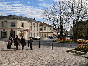
 Center of Le May-sur-Èvre |
||
Le May-sur-Èvre is a French commune with 3,805 inhabitants (as of January 1, 2017). It is located in the department of Maine-et-Loire in Région Pays de la Loire . Le May-sur-Èvre belongs to the Arrondissement of Cholet and the canton of Saint-Macaire-en-Mauges (until 2015: canton of Beaupréau ). The inhabitants are called Maytais (es) .
geography
Le May-sur-Èvre is located about seven kilometers north of Cholet in the Mauges countryside on the river Èvre . Le May-sur-Èvre is surrounded by the neighboring communities of Beaupréau-en-Mauges in the north and north-east, Trémentines in the east, Cholet in the south, Saint-Léger-sous-Cholet in the south and south-west and Bégrolles-en-Mauges in the west.
history
The original name of the place was Ulmetum . This suggests that even before the invasion of other tribes at the time of the Great Migration, i. H. a (Gallo) Roman settlement already existed before the fifth century AD. It was not until 1881 that the place was given its current name.
Population development
| year | 1962 | 1968 | 1975 | 1982 | 1990 | 1999 | 2006 | 2011 |
| Residents | 3,091 | 3,383 | 3,551 | 3,806 | 3,914 | 3,891 | 3,790 | 3,992 |
Attractions
- Saint-Michel church (called The Giant of Mauges ) from the 15th century (see also: List of Monuments historiques in Le May-sur-Èvre )
- Saint-Tibre Chapel
- Notre-Dame de Miséricorde chapel, built in 1875,
- Cazeau Castle
- Former Roman road
Personalities
- Jean Victor Tharreau (1767–1812), division general, born here
literature
- Le Patrimoine des Communes de Maine-et-Loire . Flohic Editions, Volume 1, Paris 2001, ISBN 2-84234-117-1 , pp. 334-336.

