
Neuwerk lighthouse
| Neuwerk lighthouse | ||
|---|---|---|
 |
||
| Place: | Neuwerk | |
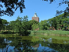
| Location: | on the southern end of the island of Neuwerk at the mouth of the Elbe | |
| Geographical location: | 53 ° 54 '54.8 " N , 8 ° 29' 45" E | |
| Height of tower base: | 1 m | |
| Fire height : | 38 | |
|
||
| Identifier : | until February 2014: Blk. (3) wrgn. 20 s 16–11 nm afterwards: F. 3 nm |
|
| Scope knows: | 16 nm (29.6 km ) | |
| Scope green: | 11 nm (20.4 km ) | |
| Scope red: | 12 nm (22.2 km ) | |
| Optics: | Belt optics, Gebr. Picht, Rathenow | |
| Operating mode: | electrical, 11 watt LED since Feb. 2014 | |
| Function: | Cross brand fire | |
| Construction time: | 1300-1310 | |
| Operating time: | December 20, 1814 to February 10, 2014 | |
| International ordinal number: | B 1344 | |

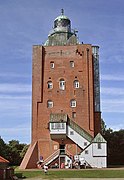
The Neuwerk tower , large tower , Neuwerk lighthouse or simply the new factory is the most important structure on the island of Neuwerk , which is part of Hamburg . The former defense , residential and lighthouse is the oldest secular structure on the entire German coast.
function
The tower had and has multiple functions:

- At first it served as a defense tower . The troop of soldiers stationed there was supposed to protect the mouth of the Elbe from sea and beach robbers.
- Over the centuries, the tower has been a refuge during storm surges for the local islanders.
- As the official residence of the captain, it was the outpost of the Hamburg head of state and customs office until the Ritzebuettel was conquered by Hamburg in 1393 .
- As the tallest building on the North Sea coast, the tower was visible from afar and the target of the following bearings:
- Tower → Scharhörnbake → Rothe Tonne
- Tower → Blüse → Nordbake (blackout beacon) → Schartonne
- Tower → Small lighthouse ( leading light ) → Schartonne
- Tower → Werkbalger Bake → Butter barrel
- Carrier for the large beacon from 1814. The only lighthouse after the fire was extinguished on the small lighthouse in 1885.
history
On November 1, 1299, Hamburg was given the right to build a tower on Neuwerk as a navigation mark and as an outpost against sea and beach robbers. Construction of the tower began in 1300 and was completed in 1310. The architecture corresponds to that of a Norman tower house, which was still frequently built at that time . Contrary to other representations in the literature, the building was constructed in its present form from the beginning; however, the tower burned down around 1372, so that it had to be extensively renewed.
The original lead roof was replaced by copper in 1474. In 1558 it was replaced by a red tile roof and more recently the tower was again covered with copper, which was "drafted into army service" in 1916 and later renewed.
In July 1825, the tower served as the northernmost measuring point for the Gaussian land survey , a triangulation of the Kingdom of Hanover by Carl Friedrich Gauß . A section of the triangulation network was found on the back of the 10 DM notes from the last series (1989–2001).
The Neuwerk lighthouse is officially Hamburg's oldest building. According to another definition, this is the Sinstorf Church , which, however, stands in an area that has only belonged to Hamburg since the Greater Hamburg Act of 1937.
The lighthouse has been a listed building since 1924 (the Turmwurt since 1971) and is today the oldest fire bearer in Germany. It has also been used as a guesthouse and restaurant for a long time .
beacon
As early as 1539, the Carta Marina recorded a fired nautical mark on Neuwerk. This representation is probably wrong, since it was not reported until 1644 that a coal flower was built as a night vision sign . From 1761 onwards, it required 1,000 tons of imported coal from Scotland for year-round firing , which had a higher bitumen content and thus produced a brighter, glowing fire than hard coal from Germany.
It was not until 1814 that the watchtower was converted into a lighthouse. The first beacon consisted of 21 hollow-core argand lamps and parabolic mirrors . These were initially operated with rapeseed oil and from 1870 with petroleum . In 1892 a belt lens with a focal length of 700 mm was installed and a five-wick kerosene lamp was used to achieve even more brightness. This lens is still used today. In 1908 the beacon was again replaced by a petroleum incandescent light before it was converted to electricity in 1942. The electrical operation was necessary in order to be able to switch the fire on and off quickly during war . Since there was no emergency power, the petroleum fire was retained as a replacement and propane gas was installed as a replacement in 1949. In 1952 the light intensity was given as 5700 Hefner candles , 13200 sea-side, 1000 for the red light and 550 Hefner candles for the green light. The range of the 1000 watt light bulb was approx. 30 km. In good weather it was visible to Heligoland (about 50 km). In autumn 2007 the classic incandescent lamp was exchanged for a halogen incandescent lamp , on February 10, 2014 the conversion to LED took place .
Although the lighthouse belongs to the city of Hamburg as a structure, the fire was operated by the Cuxhaven Waterways and Shipping Authority, which is responsible for the fairway in the Elbe estuary. Since it is no longer required for continuous shipping, the federal government handed it over to the Hamburg Port Authority (HPA) on January 1, 2014 . On February 10, 2014, after almost 200 years, the beacon was switched off as an official sea mark and continued to be operated by the Hanseatic City of Hamburg as a so-called “private fire”. The former colored identifier “Blk. (3) w. r. gn. 20 s 16–11 nm “of the night sea sign was changed to a fixed white all-round light with a range of only 3 nm.
The blues was replaced after the commissioning of the lighthouse by a small lighthouse that stood until 1909 and together with the great lighthouse, a leading light allowed for the safe passage of the northwest over the Vogelsandsteert. This is why the tower was also called the “Great Lighthouse”.
use
In addition to the three floors of guest rooms in the Leuchtturm Neuwerk guesthouse , the tower also houses a restaurant that is currently closed. The former island teacher Heinrich Gechter initiated the use of the tower as a school camp for students from Winterhude in 1920 , before moving to the attic of the state barn in 1924. For many years there was also an attic room for the Neuwerker Vogelwart of the Jordsand Association . The lighthouse has a viewing platform at a height of around 40 meters that visitors can reach via 138 steps. It allows a view of the entire island, as well as the neighboring island of Scharhörn and the shipping traffic on the Outer Elbe and Outer Weser . When the weather is good, a wide view opens up over the German Bight , including as far as Cuxhaven and the industrial plants of Bremerhaven and Wilhelmshaven .
View from the east

The area around the tower
View from the Herrengarten

Inscription to the left of the entrance

Hamburg coat of arms to the right of the entrance
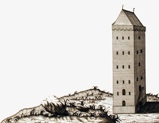
Tower around 1751 before being converted into a lighthouse
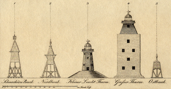
The towers and beacons of Neuwerk (1825/1831)

Neuwerk as the northernmost point of the Gauss triangulation network


.jpg)


literature
- Ferdinand Dannmeyer (Ed.): A tower and its island - monograph of the North Sea island of Neuwerk . Verlag der Buchhandlung August Rauschenplat, Cuxhaven 1982, ISBN 978-3-767207-89-9
- Arnold Kück: Under the Rainbow - Poems about Neuwerk . Arnold Kück, Hamburg 1988, ISBN 3-920-70922-5
- Frank Rudolph: Beach finds . Wachholtz-Verlag, 2007, ISBN 3-529-05413-5
- Artur Dieckhoff, Hagen Zielke: Hurricane over Neuwerk or - The secret of the Ostbake . Grethem-Büchten / Black Art, Hamburg 2008, ISBN 978-3-927840-36-2
Web links
- Pension Leuchtturm Neuwerk
- Sketches of the lighthouses and beacons , 1892
- private page to Neuwerk lighthouse
- Tower on the island of Neuwerk. Reconstruction drawing of the building situation in 1568 after Melchior Lorck by Wolfgang Braun
- 360 ° Neuwerk panoramic view from the viewing platform, on panorama-photo.net, labeling of visual targets can be activated
Individual evidence
- ^ Johann Martin Lappenberg : Hamburgisches Urkundenbuch . tape 1 , no. 918 . Voss, 1842, p. 762 ( No. 918 ).
- ^ Friedrich Becker: Cuxhaven and the Office Ritzebüttel . Otto Meißner, Hamburg 1880, p. 242 (Hamburg State and University Library, digitized version ).
- ↑ Kurt Ferber: The tower and the beacon on Neuwerk . In: Association for Hamburg History (ed.): Journal of the Association for Hamburg History . tape 14 . Johann August Meißner, Hamburg 1909, p. 1–36 ( uni-hamburg.de ).
- ^ Gaussian land survey
- ↑ see list of cultural monuments in the Hamburg district of Hamburg-Mitte
- ↑ Arend Lang : History of the sea mark system. Development, establishment and administration of the navigation system on the German North Sea coast until the middle of the 19th century . Ed .: The Federal Minister of Transport. Bonn 1965, p. 34 .
- ↑ The Neuwerker Feuerblüse ( Memento from January 7, 2010 in the Internet Archive ), www.janmaat.de/bluese.htm
- ^ Neuwerk , Red Sand Lighthouse Development Association
- ↑ a b c Neuwerk lighthouse "works" - fire stays! Waterways and Shipping Office Cuxhaven, December 31, 2013 (PDF)
- ^ Ferdinand Dannmeyer : A tower and its island - monograph of the North Sea island of Neuwerk . 1952, p. 63, "Tower and Leutchfeuer in their meaning for shipping", Helmut Schmidt
- ↑ Announcements for Seafarers 15/14: Archived copy ( Memento from March 4, 2016 in the Internet Archive )
- ↑ Neuwerk - lighthouse remains in operation . In: Leuchtfeuer No. 67, spring 2014, Klaus Kern, Rüsselsheim 2014; P. 13
- ^ Heinrich Gechter: Neuwerk. Island and school home. The school association Ferienheim Neuwerk of the girls' school Barmbecker Strasse 30 for the best of children in need of relaxation, 1928
- ^ Armin Clasen: The Neuwerk school home. In: A tower and its island - monograph of the North Sea island of Neuwerk. 1952, p. 159ff.
- ^ Pension Leuchtturm Neuwerk , accessed on September 7, 2019
Sorting up the Elbe:
Neuwerk |
Cuxhaven |
Billerbek |
Tinsdal |
Wittenbergen |
Leading light line Blankenese ( Unterfeuer Blankenese •
Oberfeuer Blankenese ) |
Estuary |
Leading light line Bubendey-Ufer ( lower light Bubendey-Ufer •
upper light Bubendey-Ufer ) |
Altenwerder |
Ellerholz |
Ellerholzhafen |
Colorful house