
Fort Zugmantel
| Fort Zugmantel | |
|---|---|
| limes | ORL 8 ( RLK ) |
| Route (RLK) |
Upper German Limes , route 3: western Taunus route |
| Dating (occupancy) | around 90 to around 260 |
| Type | a) -c) Numerus fort d) Cohort fort |
| unit | a) -c) Numerus Treverorum d) Cohors I Treverorum equitata |
| size | a) 0.7 ha b) 1.1 ha c) 1.7 ha d) 2.1 ha |
| Construction | a) -b) wood c) -d) stone |
| State of preservation | clear traces of the terrain, reconstructed watchtower north of the fort |
| place | Taunusstein - Orlen |
| Geographical location | 50 ° 11 '22.9 " N , 8 ° 12' 12.4" E |
| height | 455 m above sea level NHN |
| Previous | Small fort Adolfseck (west) |
| Subsequently | ORL 9 Alteburg Castle (east) |
| Backwards | Heidekringen small fort (south) |
The Zugmantel Fort is a former Roman garrison that was designed for an occupation the size of a cohort . The facility is located on the western Taunus stretch of the Upper German Limes , which has been a UNESCO World Heritage Site since 2005 . The ground monument , which can still be clearly seen above ground, is located in the edge of the forest from Taunusstein - Orlen in the Hessian Rheingau-Taunus district .
location

The remains of the fort and the vicus as well as a reconstructed watchtower with a reconstructed section of the Limes are located about a kilometer northeast of the town of Taunusstein-Orlen, directly at the point where Hünerstraße - today's federal highway 417 - the Limes between Orlen and Ehrenbach crosses.
The Hünerstraße was before and during the Roman times an important route connecting to that of Germans densely populated Limburger Basin and the Rheingau with Aquae Mattiacorum , today's Wiesbaden , as the capital of the Civitas Mattiacorum and Mogontiacum , today's Mainz , the capital of the Roman province of Germania superior . Military surveillance was necessary to secure this area.
Today's ground monument is located at around 455 meters above sea level on the edge of a larger forest. The southern and southeastern areas of the findings are disturbed by the construction of a sports field and a commercial enterprise. Further disruptions to the complex of findings resulted from the modern expansion of Hünerstrasse .
Nowadays, an approximately 2.5 km long nature trail leads through the facility.
Research history

One of the earliest investigations into a Limes fort from 1760 is available about Fort Zugmantel.
Around the middle of the 19th century, the historical association for Nassau carried out the first small archaeological excavations at Fort Zugmantel. Systematic scientific investigations were then carried out by the Imperial Limes Commission from 1894 and finally in the 20th century by the Saalburg Museum . The most extensive exploration was carried out from 1901 to 1914. From 1905 to 1914, Kaiser Wilhelm II visited the excavation site several times, even during the First World War . The interrupted excavations were continued from 1921 to 1937, partly as job creation measures. Further excavations followed in 1949, 1950 and 1956.
Findings

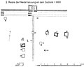
In its last construction phase, the Zugmantel fort had dimensions of 124.5 × 171 meters and a total area of 2.1 hectares. This made it the smallest fortress of a Cohors equitata in the entire Limes. The defensive wall was surrounded by a simple moat, the corners of the fort were rounded and not reinforced with towers. For this purpose, all four gates of the camp were equipped with double towers. From the development of the interior of the fort, the principia (staff building) could be fully proven, the remaining buildings are likely to have consisted of wood or half-timbered. From the fort area come fragments of a large bronze garment that date back to the first half of the 3rd century.
With the Porta praetoria (main gate), the fort was not facing north towards the Limes in all four construction phases, but facing east. A road that bends diagonally from the fort connected the main gate with the source of the Aar , which rises southeast of the camp . The fort bath was built there and the road between the bath and the fort developed into a triangular square that formed the core of the vicus (civil settlement).
The extensive vicus extended around the entire fort area. Numerous residential buildings, some with underfloor heating, as well as a total of three sacred buildings , including a sanctuary dedicated to the soldier god Jupiter Dolichenus , were found in it. The vicus is one of the best-researched fort vici on the Upper German Limes. Ceramic finds suggest that part of the settlement was inhabited by Teutons in the 3rd century. The burial ground was also located, it is located south of today's sports field.
Today there is a full-grown mixed forest on the entire site of the fort, which means that the interior buildings can no longer be recognized. The fortifications of the actual fort can still be seen as an earth wall or embankment. The Limes pile ditch is well preserved and restored in the immediate vicinity of the reconstructed watchtower (Wp. 3/15). Between the Limes and the fort one can find the remains of two small amphitheaters belonging to the vicus , which in earlier times were mistaken for entrenchments . Very similar structures were discovered at Fort Dambach , in Wales at Fort Tomen y Mur and at the nearby Arnsburg Fort .
- Fort village and amphitheater (so-called "Rundschanzen") at Fort Zugmantel
Vicus south of the fort

Vicus east

Northern amphitheater

Northern amphitheater as it is today

Eastern amphitheater

Eastern amphitheater as it is today

North wall of the fort

Preserved Limeswall


Dating, occupancy and history
Due to its strategically important location (see above), the Zugmantel fort is one of the oldest Roman fortifications in the Taunus . Already in the Domitian times, around the year 90, the first numerus fort of about 0.7 hectares in wood-earth construction was built here. Under Hadrian around the year 120 it was expanded to about 1.1 hectares. The crew was a Treverian auxiliary force (Numerus Treverorum) . This will initially have had a strength of around 160 men, but was likely to have been strengthened later, which is indicated by the repeated expansions of the fort.
In the Antonine period, around the middle of the 2nd century, the wooden fort was replaced by a stone fort of around 1.7 hectares. During the renovation phase, the Heidekringen small fort probably served as a temporary facility . Under Caracalla , the number of Cohors I Treverorum equitata ("1st partially mounted cohort of Treverians") was increased to a strength of almost 500 men. The fort was expanded again to around 2.1 hectares around 223 (or a little earlier, as an inscription mentions Caracalla). One of the latest finds of inscriptions from the Limes is in the form of a consecration stone for Emperor Maximinus Thrax . The Trever cohort is nicknamed Maximiniana here to express its bond with the ruler. The inscription was smashed after 238 and built into a pillar foundation, which could therefore have been built at this time at the earliest.
During the internal and external political and economic crisis of the empire around the middle of the 3rd century, the Limes and with it the fort was abandoned around the year 260 ( Limesfall ). In the 18th century, the remains of the camp were used as a quarry when the Hühnerstraße was expanded. Furthermore, parts of the vicus were finally destroyed by the construction of this road, a factory and a sports field.
A small selection of the finds can be found in the Limes information center of the Rheingau-Taunus district at the Georgenthal estate .
Limes course from Fort Zugmantel to Fort Alteburg
In Wp 3/18, the course of the Limes is again divided into an older, somewhat rearward line, which takes the topographical conditions more into account and is therefore irregular, and a younger line, which strives for a more straight line. The older line is probably of Domitian origin and was possibly established as early as the end of the Chatten Wars , around the year 85 AD. It only went through the first two expansion phases of the Limes (forest aisle with post path, wooden towers and palisade) and was probably replaced towards the middle of the 2nd century by the younger line, advanced up to 800 m further north, which immediately became the third Expansion phase (with stone towers instead of wooden towers) was carried out.
From Fort Alteburg to Fort Zugmantel the Limes stretches in an easterly direction with a slight deviation to the north. In doing so, it essentially passes densely forested areas in which it is very well preserved, as well as agricultural areas, on and below which its state of preservation is not so good. In total, it drops more than 100 meters in altitude on this way.
| ORL | Name / place | Description / condition |
|---|---|---|
| ORL 8 | Fort Zugmantel | see above |
| Wp 3/15 | Lost tower part of a stone tower. Its remains fell victim to construction work on Bundesstrasse 417 , the old Hühnerstrasse, in 1966 .
Not far to the east of the actual find site, the reconstruction of a stone tower and a piece of Limes with a palisade were built in 1971/72. An archaeological hiking trail that leads to the Zugmantel fort begins at this point. Guided tours of the tower are currently available.
|
|
| Wp 3/16 to Wp 3 / 17a | A total of three, based on the average distances between Limes watchtowers, suspected but not archaeologically proven tower locations | |
| Wp 3/18 | "Old Schanz" |
Tower site with two wooden towers and a stone tower.
The four post holes of the western wooden tower form a square with an aspect ratio of 3.2 m to 3.5 m. The tower was surrounded by two moats. The diameter of the inner ring trench was 11.7 m, that of the outer 19.0 m. The outer trench was somewhat less deep than the inner one. The eastern wooden tower had a moat in the form of a square with sharply rounded corners. The side of the trench was twelve meters. The findings inside the trench were probably not searched for. The floor plan of the stone tower formed an irregular square with sides between 4.75 m and 5.05 m. Its wall thickness was 95 cm, the distance to the palisade ditch 28 m. At Wp 3/18 the course of the Limes is divided into an older and a younger line. |
| Wp 3/19 | "On the Birk" |
Tower site, which was excavated in 1846 by the Nassau archive director Wilhelm Ludwig Freiherr von Preuschen (1806–1864) and examined again in 1853 by Karl August von Cohausen . The Reichs-Limeskommission refrained from further excavations.
According to Cohausen, the tower site is said to have consisted of a single stone tower, which had a wall thickness of 70 cm with an aspect ratio of 4.52 m to 4.68 m. The tower was about 15 m away from the bottom of the Limes trench. However, Cohausen's measurements and the reliability of the data obtained and documented by him were called into question in the Limeswerk (1936). |
| Wp 3/19 * | "Eschenhahner Turnplatz" |
Tower location of a single wooden tower that was examined by Heinrich Jacobi in 1899 . The tower had an approximately rectangular shape with sides 4.70 to 4.90 m. At the corners of the drywall foundation there were posts 30 cm to 35 cm thick, the sides each had three slots designed to accommodate beams. At a distance of 1.50 m, the tower was from a square trench with a side length of 8.80 m. The trench was around 1.20 m wide, the remaining depth of the rounded bottom was 75 cm.
The distance from the tower point to Wp 2/19 was 570 m, the shortest distance to the front Limes line was 480 m. Although the tower was positioned relatively low, it still afforded a good view of the Echenhahn Valley to the northwest. |
| Wp 3/20 | "On the Lower Roßberg" | Tower location of a single stone tower, the rising masonry of which at the time of the Reich Limes Commission (here: 1899) was still up to over a meter. The tower with an almost square floor plan of around four meters in length had only 60 cm thick masonry. |
| Wp 3/21 | "On the Siebenkippelstrasse" |
Tower location of a single stone tower that had already been examined by the Wiesbaden archivist Carl Rossel and later by Karl August von Cohausen.
At the time of the investigations by the RLK, the rising masonry was still up to a height of one meter, the foundation reached 35 cm into the ground. The tower had the ground plan of an irregular square with sides between 4.65 m and 4.90 m. Its wall thickness was 75 cm. The tower was in an excellent position. From this point there was a clear view to the west up to Wp 3/19 and to the east up to Wp 3/29. |
| Wp 3/21 * | "On the Siebenkippelstrasse" |
Tower site of a single wooden tower. The construction of the tower corresponded to that of Wp 3/19 *, but Wp 3/21 * was much better preserved than it was excavated by Heinrich Jacobi in 1899. The tower had a square floor plan with only slight deviations of the individual side lengths from each other, which were 4.82 m to 4.85 m. At its corners were posts 34 cm to 37 cm thick, they were cut with sharp edges. The post holes reached a depth of 1.50 m below the Roman level, a meter of which reached into the natural slate rock soil. The dry masonry, made of Taunus slate, was neatly worked flush on the outside of the tower, but of an irregular shape on the inside. The interior was filled with clay. Under the masonry there were wooden sleepers 20 cm to 30 cm high and up to 60 cm wide, which were placed in a channel carved out of the rock. After the beams rotted, the masonry subsided on all sides. In the dry masonry there were 20 cm by 40 cm slots in rows one above the other to accommodate upright stabilizing beams. The tower was surrounded on three sides by a shallow drainage ditch at a distance of 1.50 m. On the northwest side, on which there is a steep slope, the ditch suspended. The distance between the tower and the front Limes line was 490 m. The positioning was chosen brilliantly and offered an optimal view in all directions. |
| Wp 3/22 | "Hahlgarten" |
Tower part of a single stone tower that has already been examined by both Rossel and Cohausen, with contradicting documentation of the findings. The imperial excavation finally documented an approximately square floor plan with sides 4.40 m to 4.55 m. At that time, the rising masonry was still almost a meter high. The wall thickness was 90 cm. The tower was surrounded by a flat, irregularly rounded drainage ditch at a distance of around four meters. The distance from the tower to the Limes passing in a northerly direction was ten meters to the bottom of the large trench and 14.5 m to the palisade trench. |
| Wp 3/23 | "Buchwies" |
The tower was excavated by Carl Rossel in 1868 and later examined by the Imperial Limes Commission, of which nothing can be seen today. The site was a complex of findings made up of a stone tower and other findings, which were interpreted as remains of a barracks, a fireplace and a grave mound that had been dismantled.
The stone tower had a slightly irregular floor plan with the side lengths of 4.05 m × 4.50 m × 4.15 m × 4.15 m, the thickness of the masonry was 75 cm. The tower was located 9.30 m behind the bottom of the large trench and 15.0 m behind the palisade trench. |
| Wp 3/23 * | "Füllenweide" | Tower location of a wooden tower that was examined in 1899. Four post holes were found on a leveled surface, which resulted in a rectangle 5.10 m long and 4.20 m wide. The tower was surrounded by a moat in a slightly oval shape, the diameter of which was 13.0 m at the longest and 12.2 m at the narrowest point. |
| Wp 3/24 | Due to the distance between Wp 3/23 and Wp 25, a suspected but not archaeologically proven tower site. | |
| Wp 3/25 | "Gerlohe" | Tower location of a stone tower that was first excavated by Prussia in 1846 and then repeatedly examined by Karl August von Cohausen between 1853 and 1880. Of the tower, which was still well preserved in Cohausen's time (picture left), only a ransacked hill can be seen in the area today. The watchtower had a square floor plan with a side length of 4.48 m. The wall thickness as it rose was 75 cm, the foundation plinth protruded ten centimeters. |
| Wp 3/26 | "On Oberseelbach-Idsteiner Strasse" |
Tower site of a stone tower that was almost completely demolished in the 19th century.
An authentic reconstruction of a tower, the so-called "Römerturm Idstein-Dasbach", was built in its place in 2002. It is considered a successful attempt at reconstruction and houses a small exhibition inside.
|
| Wp 3 / 26a |

There are rumors that the tower of the Evangelical Chapel in Idstein - Dasbach was built on the foundations of the old Limes tower.
A legend states that the local Protestant church in Idstein-Dasbach was built on the foundations of this tower. There are no scientific findings on this, which means that these rumors must be relegated to the area of speculation. The church is definitely in the Limestrasse area. |
|
| Wp 3/27 | "East of Dasbach" | By von Preuschen in 1846 and later by von Cohausen examined, but contradictingly documented, the tower part of a stone tower. |
| Wp 3/28 | "On Dasbach-Lenzhahner Strasse" | Point of a stone tower mentioned by Rossel and Cohausen, but also contradicting and insufficiently documented. |
| Wp 3/29 | "At the triangle" |
Tower part recorded and examined in 1899, consisting of a wooden and a stone tower. The stone tower had a slightly irregular square floor plan with sides of 3.80 m to 4.00 m. The wall thickness could only be determined in the foundation, where it was between 85 cm and 95 cm.
The wooden tower was of a square type, similar to the watchtowers Wp 3/19 * and Wp 3/21 *. The four stud posts formed a trapezoidal floor plan with a side length of 3.06 m to 4.38 m. The tower was surrounded by a trapezoidal trench with sides between around 8.0 m and approximately 9.0 m. The distance from the tower to the palisade was 15 m, the distance from the bottom of the Limes ditch 12 m. |
| KK | "Small fort Eichelgarten" | About 150 m behind the Limes there are still visible soil deformations of a finding interpreted by the Reich Limes Commission as a possible small fort, which had already been documented by Rossel and Cohausen. The commission identified a trapezoidal earthwork with a flat wall and shallow ditch, but contented itself with measuring and describing the visible deformations of the soil and did not undertake any excavations. Inside was a low hill, which was surrounded by a shallow, 6.50 m diameter, circular ditch. If the complex was supposed to be a Roman fort, it was probably only in use for a short time. Judging by the name and the findings, it is very likely a modern oak plantation, of which there are similar ones in the Taunus. |
| Wp 3/30 | "Gerheck" | Tower location of a stone tower with a trapezoidal floor plan (north side 4.10 m, south side 3.80 m, west and east side each 4.00 m). The walls were 75 cm thick, the distance between the tower and the center of the Limes ditch was 11.2 m. The front of the stone tower was about 13 m from the bottom of the trench and 17 m from the palisade. |
| Wp 3/31 | "Untimely piece" |
Findings from a stone watchtower and another building. The stone tower had a rectangular floor plan with side lengths between 3.95 m and 4.10 m. The thickness of the rising masonry was 90 cm, the foundation base protruded by 10 cm.
The second building was about 56 m west of the watchtower and only nine meters behind the bottom of the Limes trench. This building was probably not a watchtower, but a building for a different purpose. It had a rectangular floor plan with a width of 6.00 m and a length of 7.20 to 7.25 m. The wall thickness was only 50 cm as it rose, the foundation plinths protruded 15 cm on the inside. |
| ORL 9 | Alteburg Castle | see main article Kastell Alteburg |


Others
In the area of the fort there is an occurrence of the small evergreen . It can, as u. a. at the Holzhausen fort , can be traced back to a Roman period planting.
Monument protection
The Zugmantel fort and the adjoining Limes structures have been part of the UNESCO World Heritage as a section of the Upper German-Raetian Limes since 2005 . In addition, they are ground monuments according to the Hessian Monument Protection Act . Treasure finds were reported in 1912 (140 denarii and antoninians) and 1931 (14 sesterces). Investigations and targeted collection of finds are subject to approval, and accidental finds are reported to the monument authorities.
See also
literature
- Dietwulf Baatz : train coat. In: The Romans in Hesse. Nikol, Hamburg 2002, ISBN 3-933203-58-9
- Dietwulf Baatz: The Roman Limes. Archaeological excursions between the Rhine and the Danube. Gebr. Mann, Berlin 2000, ISBN 3-7861-2347-0
- Dietwulf Baatz: The stamped bricks from the bath of the Zugmantel fort . Saalburg-Jahrbuch 24, 1967, pp. 40–74.
- Astrid Böhme: The fibulae of the castles Saalburg and Zugmantel . Saalburg-Jahrbuch 29, 1972, pp. 5–112.
- Ernst Fabricius , Felix Hettner , Oscar von Sarwey (Hrsg.): The Upper Germanic-Raetian Limes of the Roemerreiches / Abt. A, Vol. 2.1. The routes 3 to 5. Petters, Heidelberg, Berlin and Leipzig 1936, p. 61ff. as well as table 5, fig. 3 and 4.
- Fritz-Rudolf Herrmann : Fort Zugmantel and the Limes near Orlen. Department for Prehistory and Early History in the State Office for Monument Preservation Hessen, Wiesbaden 1983, ISBN 3-89822-033-8 (Archaeological Monuments in Hessen 33)
- Gerhard Honekamp : The Limes - not just a border. The Roman fort Zugmantel. In: Everyday life between the mighty and the idlers - historical explorations in Wiesbaden and the surrounding area. Breuer, Wiesbaden-Erbenheim 1995, ISBN 3-9804701-0-5 , pp. 131-134.
- Louis Jacobi in: The Upper Germanic-Raetian Limes of the Roemerreich , (Eds. Ernst Fabricius, Felix Hettner, Oscar von Sarwey), Department B, Volume II, 1 Fort No. 8 (1909)
- Werner Jorns : The excavations on the Zugmantel in autumn 1935. Saalburg-Jahrbuch 10, 1951 pp. 50–54.
- Margot Klee : The Roman Limes in Hessen. History and sites of the UNESCO World Heritage. Verlag Friedrich Pustet, Regensburg 2009, ISBN 978-3-7917-2232-0 , pp. 81-87
- Margot Klee: The Limes between Rhine and Main. From the beginning of the Upper German Limes near Rheinbrohl to the Main near Grosskrotzenburg. Theiss, Stuttgart 1989, ISBN 3-8062-0276-1
- Marcus Reuter : Cohortes Treverorum on the Taunus Limes? For the occupation of the fort Zugmantel and Holzhausen. In: Andreas Thiel (ed.): New research on the Limes . 4th specialist colloquium of the German Limes Commission 27./28. February 2007 in Osterburken. Theiss, Stuttgart 2008, ISBN 978-3-8062-2251-7 , (= contributions to the Limes World Heritage Site, 3), pp. 83–91.
- Hans Schönberger : Plan for the excavations at the Zugmantel fort up to 1950. Saalburg-Jahrbuch 10, 1951 pp. 55–75.
- Nina Schücker, Thomas Manuel: The Sigillata Collection from Cellar 256 of the Zugmantel vicus - a vessel ensemble from the sanctuary for Iuppiter Dolichenus? . Saalburg-Jahrbuch 54, 2004, pp. 161–196.
- C. Sebastian Sommer : Fort vicus and fort. In: Find reports from Baden-Württemberg 13, 1988 pp. 457–707.
Web links
- Fort Zugmantel on the side of the German Limes Commission
- Fort Zugmantel on the private project website taunus-wetterau-limes.de
Remarks
- ↑ See Fritz-Rudolf Herrmann: The archaeological research of the Roman era in Hesse. In: D. Baatz, F.-R. Hermann: The Romans in Hesse. Theiss, Stuttgart 1989, p. 18. The text still bears the very cumbersome title “News of the opportunity of some Roman entrenchments in the former field trains in Germany, as they are currently still located and to be seen, along with a map as well as possible Investigation of time and intention. ”The author was Karl-Phillip de Biebourg, a son of Prince Karl von Nassau-Usingen from an morganatic marriage.
- ↑ Martin Kemkes : The image of the emperor on the border - A new large bronze fragment from the Raetian Limes . In: Andreas Thiel (Ed.): Research on the function of the Limes , volume 2. Konrad Theiss Verlag, Stuttgart 2007, ISBN 978-3-8062-2117-6 , p. 144.
- ↑ See in detail C. Sebastian Sommer: Kastellvicus und Kastell. In: Find reports from Baden-Württemberg 13, 1988, pp. 457–707.
- ^ Margot Klee: The forts Saalburg and Zugmantel in the 3rd century. In: Egon Schallmayer (Ed.): The Augsburg victory altar - testimony to a troubled time. Saalburgmuseum Bad Homburg vd H. 1995, p. 45.
- ^ Anne Johnson (German adaptation by Dietwulf Baatz ): Römische Kastelle . Verlag Philipp von Zabern, Mainz 1987, ISBN 3-8053-0868-X , p. 240.
- ↑ CIL 13, 11971 .
- ↑ a b W p = W oh p east, watch tower. The number before the slash denotes the Limes section, the number after the slash denotes the respective watchtower. An additional asterisk (*) refers to a guard on the older Limes line.
- ↑ The differentiation in the literature is done by adding an * (asterisk) after the watchtower number, the watchtowers marked with such an asterisk belong to the older line. Wp 3/4 * denotes a wooden tower point of the older line, while Wp 3/4 denotes a stone tower of the younger line in the same Limes section. See also the note on the numbering of the Limes watchtowers.
- ↑ ORL = numbering of the Limes structures according to the publication of the Reich Limes Commission on the O bergermanisch- R ätischen- L imes
- ↑ ORL XY = consecutive numbering of the forts of the ORL
- ↑ Wp 3/15 at approximately 50 ° 11 '35.1 " N , 8 ° 12' 7.45" E
- ↑ Wp 3/15 reconstruction at 50 ° 11 ′ 34.7 ″ N , 8 ° 13 ′ 8.7 ″ E
- ↑ Wiesbadener Tagblatt: Living again on the former Limes ( Memento from April 17, 2010 in the Internet Archive ) (from April 10, 2010)
- ↑ Wp 3/16 at approximately 50 ° 11 '34.77 " N , 8 ° 12' 30.5" O , Wp 3/17 at about 50 ° 11 '32.83 " N , 8 ° 12' 49.64 " O and Wp 3 / 17a at approximately 50 ° 11 '30.84" N , 8 ° 13' 11.2 " O .
- ↑ Wp 3/18 at 50 ° 11 '27.95 " N , 8 ° 13' 37.81" O
- ↑ 4.75 m on the west and east side, 4.90 m on the south side and 5.05 m on the north side.
- ↑ Wp 3/19 at 50 ° 11 '31.56 " N , 8 ° 14' 10.52" O
- ↑ After Carl Rossel: The Roman border defense in the Taunus . Limbarth, Wiesbaden 1876, pp. 74f.
- ^ Karl August von Cohausen: The Roman border wall in Germany. Military and technical description of the same . Kreidel, Wiesbaden 1884, p. 152, 20.
- ↑ Ernst Fabricius , Felix Hettner, Oscar von Sarwey (ed.): The Upper Germanic-Raetian Limes of the Roman Empire / Abt. A, Vol. 2.1. Lines 3 to 5. Petters, Heidelberg, Berlin and Leipzig 1936, p. 76.
- ↑ Wp 3/19 * at 50 ° 11 '18.55 " N , 8 ° 14' 36.14" E
- ↑ 4.70 m on the south, 4.75 m on the north and 4.90 m each on the west and east side.
- ↑ Wp 3/20 at 50 ° 11 '35.29 " N , 8 ° 14' 45.96" O
- ↑ 4.00 m each on the north, east and south side, 4.10 m on the west side.
- ↑ Wp 3/21 at 50 ° 11 '37.68 " N , 8 ° 15' 1.2" O
- ^ Carl Rossel: The Roman border defense in the Taunus . Limbarth, Wiesbaden 1876, p. 76.
- ^ Karl August von Cohausen: The Roman border wall in Germany. Military and technical description of the same . Kreidel, Wiesbaden 1884, p. 151, 19.
- ↑ 4.75 m on the west side, 4.90 m on the north side, 4.65 m on the east side and 4.70 m on the south side.
- ↑ Wp 3/21 * at 50 ° 11 '23.01 " N , 8 ° 15' 10.09" O
- ^ Carl Rossel: The Roman border defense in the Taunus . Limbarth, Wiesbaden 1876, p. 76 and Fig. 35.
- ^ Karl August von Cohausen: The Roman border wall in Germany. Military and technical description of the same . Kreidel, Wiesbaden 1884, p. 151, 18 and plate 18, fig. 8.
- ↑ Wp 3/22 at 50 ° 11 '41.23 " N , 8 ° 15' 29.02" O
- ↑ 4.55 m on the south, west and north sides, 4.55 m on the east side.
- ^ Carl Rossel: The Roman border defense in the Taunus . Limbarth, Wiesbaden 1876, p. 77f. and Fig. 36.
- ↑ Wp 3/23 at 50 ° 11 '42.16 " N , 8 ° 15' 38.64" O
- ↑ Wp 3/23 * at 50 ° 11 '22.35 " N , 8 ° 15' 53.21" E
- ↑ Wp 3/24 at approximately 50 ° 11 '45.09 " N , 8 ° 16' 6.62" O
- ↑ Wp 3/25 at 50 ° 11 '48.06 " N , 8 ° 16' 25.99" O
- ^ Carl Rossel: The Roman border defense in the Taunus . Limbarth, Wiesbaden 1876, p. 78f. and Figs. 37 and 36.
- ^ Karl August von Cohausen: The Roman border wall in Germany. Military and technical description of the same . Kreidel, Wiesbaden 1884, pp. 150, 15 and plate 18, fig. 5 and 6.
- ↑ Wp 3/26 at 50 ° 11 '51.87 " N , 8 ° 17' 0.47" O
- ^ Carl Rossel: The Roman border defense in the Taunus . Limbarth, Wiesbaden 1876, p. 80 and Fig. 39.
- ↑ Wp 3/26 reconstruction at 50 ° 11 ′ 51.45 ″ N , 8 ° 17 ′ 0.05 ″ E
- ↑ “The distance from Wp. 26 on Oberseelbach-Idsteiner Strasse was over 1000 m. The area in between does not offer any space that would require another watchtower, but a guard post 26a could at least be added in the north-western part of the village Dasbach, which is on a small terrace, about 600 m from Wp. 26. The Dasbacher valley, directed northwards, was clearly visible from there. ” ORL A 2.1 Route 3, p. 82
- ↑ Wp 3 / 26a at around 50 ° 11 '55.8 " N , 8 ° 17" 29.4 " E
- ^ A b Carl Rossel: The Roman border defense in the Taunus . Limbarth, Wiesbaden 1876, pp. 80f.
- ^ Karl August von Cohausen: The Roman border wall in Germany. Military and technical description of the same . Kreidel, Wiesbaden 1884, pp. 149, 13.
- ↑ Wp 3/27 at 50 ° 11 '58.73 " N , 8 ° 17' 53.46" O
- ^ Karl August von Cohausen: The Roman border wall in Germany. Military and technical description of the same . Kreidel, Wiesbaden 1884, p. 149, 12.
- ↑ Wp 3/28 at 50 ° 12 '0.85 " N , 8 ° 18' 7.6" O
- ↑ Wp 3/29 at 50 ° 12 '7.3 " N , 8 ° 18' 51.67" E
- ↑ 4.00 m on the north, 3.90 m on the east, 3.85 m on the south and 3.80 m on the west side.
- ↑ Around 8.0 m on the west side, approximately 9.0 m on the east side and 8.5 m each on the north and south side.
- ↑ Not numbered K linseed K astell
- ↑ Small fort Eichelgarten at 50 ° 12 ′ 3.84 ″ N , 8 ° 18 ′ 59.04 ″ E
- ^ Carl Rossel: The Roman border defense in the Taunus . Limbarth, Wiesbaden 1876, p. 92.
- ^ Karl August von Cohausen: The Roman border wall in Germany. Military and technical description of the same . Kreidel, Wiesbaden 1884, p. 148, 6.
- ↑ 68 m on the north side, 66 m on the south side, 46 m on the east side and 48 m on the west side, measured in the middle of the trench.
- ↑ Dietwulf Baatz: Eichelgarten small fort on the Taunus Limes - Roman building or forestry facility of the modern age? In: Peter Henrich (Ed.): Perspektiven der Limesforschung. 5th Colloquium of the German Limes Commission 19./20. May 2009 in the Roman-Germanic Museum of the City of Cologne. Theiss, Stuttgart 2010, ISBN 978-3-8062-2465-8 , pp. 156-165 ( contributions to the Limes World Heritage Site 5).
- ↑ Wp 3/30 at 50 ° 12 '14.94 " N , 8 ° 19' 9.72" O
- ↑ Wp 3/31 at 50 ° 12 '20.98 " N , 8 ° 19' 24.56" O
- ↑ 3.95 m on the north, 3.95 m on the east, 4.10 m on the south and 4.05 m on the west.
- ↑ Christian Stolz (2013): Archaeological pointer plants: case studies from the Taunus and northern Schleswig-Holstein. Plants as indicators for archaeological find sites: Case studies from the Taunus Mts. and from the northern part of Schleswig-Holstein (Germany) . - Writings of the Regional and Folklore Working Group 11: pp. 1–30 [1]
- ↑ Fund coins from the Roman era in Germany FMRD V, 1,2 Wiesbaden 218 No. 1226
- ↑ Fund coins from the Roman period in Germany FMRD V, 1,2 Wiesbaden 229 No. 1228
.jpg)