
Limeshain
| coat of arms | Germany map | |
|---|---|---|

|
Coordinates: 50 ° 16 ' N , 9 ° 0' E |
|
| Basic data | ||
| State : | Hesse | |
| Administrative region : | Darmstadt | |
| County : | Wetteraukreis | |
| Height : | 206 m above sea level NHN | |
| Area : | 12.5 km 2 | |
| Residents: | 5747 (Dec. 31, 2019) | |
| Population density : | 460 inhabitants per km 2 | |
| Postal code : | 63694 | |
| Primaries : | 06047, 06048 | |
| License plate : | FB, BÜD | |
| Community key : | 06 4 40 014 | |
| Community structure: | 3 districts | |
| Address of the municipal administration: |
Am Zentrum 2 63694 Limeshain |
|
| Website : | ||
| Mayor : | Adolf Ludwig ( SPD ) | |
| Location of the municipality Limeshain in the Wetterau district | ||
  |
||

Limeshain is a Hessian municipality in the Wetterau . The town hall and thus the seat of the municipal administration is located in the Himbach district.
geography
The municipality of Limeshain consists of the districts Hainchen , Himbach and Rommelhausen . It borders in the west and north on the municipality of Altenstadt , in the east on the city of Büdingen , in the south on the municipality Hammersbach ( Main-Kinzig-Kreis ) and in the southwest on the city of Nidderau (Main-Kinzig-Kreis).
history
The place Rommelhausen was first mentioned in 930 as Ruommothusen . The first mention of the place Himbach can be found in a document of Heinrich IV. From the year 1057 as Hintbach . Hainchen was first mentioned in 1367 as "To the grove". Like Himbach, it belonged to the Eckartshausen court at that time .
The three localities that had previously been assigned to different districts belonged to the Büdingen district from 1874 .
On December 31, 1971, as part of the regional reform in Hesse, the municipality of Limeshain was newly formed through the merger of the previous municipalities of Hainchen, Himbach and Rommelhausen.
On August 1, 1972, the old district of Büdingen was dissolved. The Limeshain community was assigned to the new Wetterau district .
politics
Community representation
The local elections on March 6, 2016 produced the following results, compared to previous local elections:
| Parties and constituencies |
% 2016 |
Seats 2016 |
% 2011 |
Seats 2011 |
% 2006 |
Seats 2006 |
% 2001 |
Seats 2001 |
||
|---|---|---|---|---|---|---|---|---|---|---|
| SPD | Social Democratic Party of Germany | 65.1 | 18th | 55.0 | 15th | 51.7 | 14th | 52.5 | 14th | |
| CDU | Christian Democratic Union of Germany | 24.2 | 6th | 17.6 | 5 | 22.7 | 6th | 22.4 | 6th | |
| FWG | Free voting community Limeshain | - | - | 15.2 | 4th | 25.6 | 7th | 25.1 | 7th | |
| GREEN | Alliance 90 / The Greens | 10.7 | 3 | 12.2 | 3 | - | - | - | - | |
| total | 100.0 | 27 | 100.0 | 27 | 100.0 | 27 | 100.0 | 27 | ||
| Voter turnout in% | 47.8 | 46.0 | 44.0 | 49.8 | ||||||
mayor
The past mayoral elections produced the following results:
|
|||||||||||||||||||||||||||||||||||||
The mayor Adolf Ludwig (SPD), who has been in office since 2002, was re-elected for a third term of office on January 19, 2014 in the first ballot with 89.5% of the votes. The turnout was 35.3%.
Culture and sights
The Upper Germanic-Raetian Limes runs through the municipality , a border system with forts and observation towers maintained by the Romans until around 260 AD . This includes the small fort "Auf dem Buchkopf" near Rommelhausen. Remains of these fortifications that are still visible in the area today have been preserved west to south of Rommelhausen and can be explored via hiking trails created for this purpose.
A 25 meter long reconstructed section of the Limes shows the state of development around 200 AD. The reconstruction was carried out in connection with an archaeological and natural history hiking trail based on the idea of Mayor a. D. Klaus Hühn established during his term of office. A little further south, in 2013, the 11.46 meter high, reconstructed stone tower of the guard post 4/103 “Eckartshäuser Unterwald” was inaugurated.
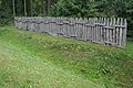
Reconstructed section of the Limes

Reconstructed Limes watchtower 4/103 at the opening

The former Himbach town hall, renovated in 1999
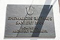
Memorial plaque at the town hall


Individual evidence
- ↑ Hessian State Statistical Office: Population status on December 31, 2019 (districts and urban districts as well as municipalities, population figures based on the 2011 census) ( help ).
- ↑ RI III, 2,3 n.112, in: Regesta Imperii Online, http://www.regesta-imperii.de/id/1057-05-28_1_0_3_2_3_112_112 .
- ^ Federal Statistical Office (ed.): Historical municipality directory for the Federal Republic of Germany. Name, border and key number changes for municipalities, counties and administrative districts from May 27, 1970 to December 31, 1982 . W. Kohlhammer GmbH, Stuttgart / Mainz 1983, ISBN 3-17-003263-1 , p. 352 .
- ^ Result of the municipal election on March 6, 2016. Hessian State Statistical Office, accessed in April 2016 .
- ^ Hessian State Statistical Office: Result of the municipal elections on March 27, 2011
- ^ Hessian State Statistical Office: Result of the municipal elections on March 26, 2006
- ↑ Limes watchtower will open on August 17th in the Wetterauer Zeiturng on August 7th, 2013, accessed on February 12th, 2020
- ↑ The Limes watchtower on the Limeshain municipal administration website
Web links
- Official website of the Limeshain community
- Limeshain, Wetterau district. Historical local dictionary for Hessen. In: Landesgeschichtliches Informationssystem Hessen (LAGIS).
- Limeshain ( Memento from July 7, 2002 in the Internet Archive ) at the German Limes Street Association
- History of Limeshain at the History and Culture Association Limeshain e. V.
- Link catalog on Limeshain at curlie.org (formerly DMOZ )

Altenstadt | Bad Nauheim | Bad Vilbel | Büdingen | Butzbach | Echzell | Florstadt | Friedberg (Hesse) | Gedern | Glauburg | Hirzenhain | Karben | Kefenrod | Limeshain | Munzenberg | Nidda | Niddatal | Ober-Mörlen | Ortenberg | Ranstadt | Reichelsheim (Wetterau) | Rockenberg | Rosbach v. d. Height | Wölfersheim | Wöllstadt