
Lister dam
| Lister dam | |||||||||
|---|---|---|---|---|---|---|---|---|---|
.JPG) |
|||||||||
|
|||||||||
|
|||||||||
| Coordinates | 51 ° 5 '38 " N , 7 ° 50' 15" E | ||||||||
| Data on the structure | |||||||||
| Construction time: | 1909-1912 | ||||||||
| Height of the barrier structure : | 42 m | ||||||||
| Crown length: | 264 m | ||||||||
| Crown width: | 7.25 m | ||||||||
| Base width: | 31.5 m | ||||||||
| Data on the reservoir | |||||||||
| Altitude (at congestion destination ) | 319.52 m above sea level NN | ||||||||
| Water surface | 1.68 km² | ||||||||
| Reservoir length | 4.5 km | ||||||||
| Reservoir width | 400 m | ||||||||
| Storage space | 21.60 million m³ | ||||||||

The Listertalsperre is a reservoir in the Olpe district and in the Märkisches Kreis in North Rhine-Westphalia ( Germany ).
Geographical location
The Listertalsperre is located in the southern Sauerland between the cities of Attendorn , Drolshagen and Meinerzhagen . In addition to numerous nameless smaller tributaries, the lake is fed by the three large tributaries Lister, Beche and Herpeler Bach, where the Lister is the namesake of the dam.
history
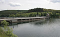
The Listertalsperre was built from September 13, 1909 to October 2, 1912. The dam , built according to the Intze principle , dams the Lister River near Hunswinkel . The British air raid on the dam as part of Operation Chastise on the night of May 16-17, 1943 was unsuccessful.
Data
Today the Listertalsperre is a branch of the Biggetalsperre built in 1965 . It has a storage volume of 21.6 million cubic meters with a maximum water depth of 33.90 meters. In the Listerkraftwerk , around 4.6 million kWh of electricity are generated annually using a Kaplan turbine . The Lister dam is 4500 meters long and up to 400 meters wide, which results in a water surface of 169 hectares. The fish population is very diverse and ranges from eels to pikeperch . In addition to white fish, the most common fish are pike and vendace . But trout are also represented. The carp population has also grown recently .
Uses
In addition to generating electricity and raising the low water level in the Ruhr , the reservoir is used for recreational activities. A hiking and cycling path leads from the dam to Kalberschnacke. Swimming and water sports (including diving since 2010 ) are permitted. There are numerous campsites and holiday apartments around the Lister Reservoir.
Rehabilitation of the dam
From the middle of 2007 to the beginning of 2009 the dam was completely renovated. Among other things, the task was to repair cracks and joints in the masonry, to renew the roadway and railings and to repair the arches of the flood relief. For the duration of the work, the top of the wall, the parking lot at the dam and the toilet facility were closed to visitors. The renovation work, especially on the railings and arches, has changed the appearance of the dam permanently.
Places on the lake
- Meinerzhagen- Hunswinkel
- Meinerzhagen- Windebruch
- Drolshagen veal snacks
- Drolshagen- Herpel
- Attendorn oaks
- Attendorn- Wörmge
Listertalsperre nature reserve
The Listertalsperre nature reserve is a 4.44 hectare nature reserve (NSG) at the inlet of the Lister into the dam. The NSG was designated in 2001 by the district council of the Märkischer Kreis with the landscape plan No. 6 Meinerzhagen . In order to maintain and secure the area where the Lister flows into the dam, the NSG was designated as a valuable breeding ground for water birds as well as the reed and floating leaf zone, which is important for vegetation. Larger stocks of water knotweed flood the water surface. The confluence area of the dam is classified as an important breeding and resting place for water birds. Great crested grebes , coot and mallard breed regularly in the reserve . The NSG is an important refuge and stepping stone biotope, especially for water birds. There is a population of the critically endangered pond mussel . Fishing is prohibited in the NSG area during the bird breeding season from April 1st to June 30th.
The Biggesee and the Listersee with bank areas have been part of the Biggesee / Listersee landscape protection area with 738 hectares since 2013 .
photos

Aerial view of the Lister dam

Dam wall: crown with hiking trail
Dam wall: waterside view
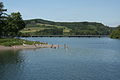
Swimming in the Listertalsperre

Sailing boats at "Gut Kalberschnacke"

Campsite at Kalberschnacke

The Herpeler Bach flows into the lake


See also
- List of lakes in North Rhine-Westphalia
- List of dams in Germany
- List of nature reserves in the Märkisches Kreis
literature
- Heinrich Zimmer: The Listertalsperre near Attendorn. With four illustrations based on original photographic images. In: Reclams Universum 28.2 (1912), pp. 831-834.
- Märkischer Kreis - Lower Landscape Authority (ed.): Märkischer Kreis: Landscape plan No. 6 Meinerzhagen , Lüdenscheid 2001, p. 66.
Individual evidence
- ↑ http://www.ruhrverband.de/presse/pressemitteilungen/detailansicht/daten/2007/05/30/sanierung-der-listerstaumauer/ ( page no longer available , search in web archives ) Info: The link was automatically marked as defective . Please check the link according to the instructions and then remove this notice.
- ↑ District of Olpe (ed.): Landscape plan No. 1 Bigge and Listertalsperre , Olpe 2013, pp. 42–43.
Web links
- Ruhrverband
- Link to the Biggesee diving school and the Kalberschnacke diving area in the Listertalsperre
- "Listertalsperre" nature reserve in the specialist information system of the State Office for Nature, Environment and Consumer Protection in North Rhine-Westphalia
Agger Valley | On the shopkeeper | On the ebb | Brauke | Duwelssiepen | Ebbebach Valley | Elmchebach Valley | Genkel Valley | Gleyer | Grotmicke | Heimche Valley | Hemche Valley / Geitsiepen | Herveler Bachtal | Holbecke | Lesmicker-Siepen | Listertal | Listertalsperre | Cams | Genkel headwaters | Schleipe valley | Narrow basin | Schoppenwasser valley | Sifter valley areas | Stone marrow | Tutmicke Valley | Versetal | Wesmecke Valley | Onion seed | Willertshagen meadows