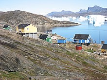
Naajaat
| Naajaat (young seagulls) | ||
|---|---|---|
| Naujât | ||
| Naajaat (2007) | ||
| Commune | Avannaata Communia | |
| District | Upernavik | |
| Geographical location | 73 ° 9 ′ 0 ″ N , 55 ° 49 ′ 0 ″ W | |
|
|
||
| Residents | 49 (January 1, 2020) |
|
| Time zone | UTC-3 | |
Naajaat [ naːˈjaːtˢʰ ] (according to the old spelling Naujât ) is a Greenlandic settlement in the district of Upernavik in the Avannaata Kommunia .
location
Naajaat is located on the island of Naajat in a small archipelago, which also consists of the larger islands of Kangilleq and Sanningasorsuaq . The next place is Innaarsuit , which is nine kilometers northwest. It is 41 km to the south to the district capital Upernavik .
history
Naajaat was inhabited at the beginning of the colonial era. In 1798 45 people lived at the residential area, which made it one of the largest towns in the district. In 1806 30 people lived in one house in Naajaat. In 1850 the place was deserted.
Naajaat was repopulated at the beginning of the 20th century. In 1911 Naajaat became part of the Qassersuaq municipality . In 1918 the residential area had 14 residents in three houses. The population soon doubled and was fairly constant between 1940 and 1970 at 25 to 30 inhabitants before it doubled again.
In 1950 Naajaat became part of the new Upernavik municipality . The place never officially received village status. During the administrative reform in 2009 Naajaat fell to the Qaasuitsup Kommunia . Since 2018 the place belongs to the Avannaata Kommunia .
economy
Most of the residents make their living from fishing. The area is rich in black halibut , but fishermen have to sell their catch in Innaarsuit as there is no fish factory in Naajaat. Tourism serves as another source of income.
Infrastructure and supply
Naajaat has little infrastructure. There is no port and the fishing boats are right on the shore. There is also no heliport and there are no paths within the village, so all the houses are free. The area is transported by dog sled and snowmobile .
Nukissiorfiit supplies the residents with electricity via a diesel power station. TELE Greenland connects you telecommunicatively. The rubbish from Naajaat is dumped, but there is no incineration plant.
Development
The Niisip Atuarfia was established in 1972 and teaches about half a dozen students. The school building also functions as a church and meeting building. Naajaat also has a library. There is no shop in Naajaat and goods are supplied via Innaarsuit.
Population development
Naajaat is one of the smaller towns in the region. The population doubled between the late 1970s and mid-2000s, but has fallen slightly since then.

panorama
Web links
Individual evidence
- ↑ Map with all official place names confirmed by Oqaasileriffik , provided by Asiaq
- ↑ Hans Jensen Bryder : Beskrivelse af Distrikterne i Nordgronland: Upernivik Island district. De enkelte Bopladser i Upernivik district. Bopladsen Naujait . In: Georg Carl Amdrup , Louis Bobé , Adolf Severin Jensen , Hans Peder Steensby (eds.): Grønland i tohundredeaaret for Hans Egedes landing (= Meddelelser om Grønland . Volume 60-61 ). tape 1 . C. A. Reitzel Boghandel, Copenhagen 1921, p. 496 ( digitized version in the Internet Archive ).
- ^ Hother Ostermann : Beskrivelse af Distrikterne i Nordgrønland: Upernivik District. History . In: Georg Carl Amdrup , Louis Bobé , Adolf Severin Jensen , Hans Peder Steensby (eds.): Grønland i tohundredeaaret for Hans Egedes landing (= Meddelelser om Grønland . Volume 60-61 ). tape 1 . C. A. Reitzel Boghandel, Copenhagen 1921, p. 508 ff . ( Digitized in the Internet Archive ).
- ↑ Jens Christian Madsen: Udsteder og bopladser i Grønland 1901-2000 . Atuagkat, 2009, ISBN 978-87-90133-76-4 , pp. 184 f .
- ↑ a b c Naajaat at qaasuitsup-kp.cowi.webhouse.dk
- ↑ Population of Naajaat 1977–2020 at bank.stat.gl


