Neckarhausen (Neckarsteinach)
|
Neckarhausen
City of Neckarsteinach
Coordinates: 49 ° 24 '59 " N , 8 ° 52' 53" E
|
|
|---|---|
| Height : | 144 m above sea level NHN |
| Area : | 69 hectares |
| Residents : | 231 (May 9, 2011) |
| Population density : | 335 inhabitants / km² |
| Incorporation : | 1st October 1971 |
| Postal code : | 69239 |
| Area code : | 06229 |

Neckarhausen is a district of Neckarsteinach in the Bergstrasse district in southern Hesse .
Geographical location
Like the core town of Neckarsteinach, Neckarhausen is also located in the Odenwald on the right bank of the Neckar . It is here, about five kilometers upstream and three and a half kilometers east-northeast of the city center, the state border between Hesse and Baden-Württemberg . The right slope of the valley, which drops slightly in front of the village and then immediately behind it again very steeply to almost the river bank and is wooded down to the bottom, has a flatter gradient here at its foot for around one and a half kilometers and is up to a width of up to 400 meters free of forest. One reason for the flattening of the slope is apparently the erosion notch of the Korbelsgrund , which flows here towards the Neckar and which has dug itself wide above the village into the heights of the Michelbucher forest , as well as a smaller gorge.
The district extends in the Neckar valley as a narrow strip of land and settlement land about two kilometers southwest between the river border and the lower edge of the forest slope of the community-free area Michelbuch . The Lanzenbach runs about a kilometer downstream from the center of the village through another gorge to the Neckar, at its mouth the district ends at the small Lanzenbach von Neckarhausen settlement. Above this, on the upward spur of the mouth of the defunct Hundheim Castle, lies the castle stables beyond the municipal boundary . The narrow right floodplain of the river from the village down to this point is taken by the Hessisches Neckartal campsite, which offers permanent camping in Neckarhausen.
The closest localities are in the west-southwest, the core town Neckarsteinach in the Neckar valley; in the west Darsberg , in the northwest the forester's house Michelbuch and behind it Grein on the right level; in the north Hirschhorn back in the valley; in the east Moosbrunn and Schönbrunn on the left edge; finally in the south beyond the Neckar on the bank the Neckarhäuserhof settlement , a district of Mückenloch in a left side valley, which lies further in the southwest.
history
middle Ages
The oldest surviving mention of the place comes from 1150 and can be found in a document that was issued as part of a gift from Bishop Gunther von Speyer to the nearby Schönau Monastery . Bishop Gunther bequeathed his property in Husen and Michelbuch (today: Wüstung ) to the Cistercian monastery founded in 1142 . Both places originally belonged to the domain of the " Hundheim " castle , which was destroyed a few years earlier, around 1130, in the course of a feud. The settlements served as farmhouses that ensured supplies to the castle. The name form Neckerhusen is documented for the first time since 1424.
Early modern age
In the Old Kingdom Neckarhausen belonged to the Electoral Palatinate , where it was subordinate to the Oberamt Heidelberg . That is why the Palatinate Land Law from 1582, renewed in 1610, was a particular law . In addition, the common law applied , insofar as the Palatinate Land Law did not contain special regulations for a matter. This special rights retained its validity and throughout the 19th century during the affiliation of the area to the Grand Duchy of Hesse and was only on January 1, 1900 by the same across the whole German Reich current Civil Code replaced.
With the Reichsdeputationshauptschluss , Neckarhausen fell to the Margraviate of Baden in 1803 , which, however, already exchanged it for other parts of the area through a contract dated March 14, 1803 with the Landgraviate of Hesse-Darmstadt . The Landgraviate incorporated it into the neighboring office of Neckarsteinach .
Modern times
Neckarhausen voluntarily joined the city of Neckarsteinach as part of the regional reform in Hesse on October 1, 1971. For Neckarhausen as well as for the other municipalities incorporated into Neckarsteinach, local districts with local advisory councils and local councilors were formed according to the Hessian municipal code.
Territorial history and administration
The following list gives an overview of the territories in which Neckarhausen was located and the administrative units to which it was subordinate:
- before 1803: Holy Roman Empire , Electoral Palatinate , Oberamt Heidelberg
- 1803: Margraviate of Baden
- from 1803: Holy Roman Empire, Holy Roman Empire, Landgraviate Hessen-Darmstadt , Principality of Starkenburg , Office Neckar-Steinach
- from 1806: Grand Duchy of Hesse , Principality of Starkenburg, Office of Neckar-Steinach
- from 1815: German Confederation , Grand Duchy of Hesse, Starkenburg Province , Neckar-Steinach Office
- from 1821: German Confederation, Grand Duchy of Hesse, Starkenburg Province, Hirschhorn District District (separation between jurisdiction ( Hirschhorn District Court ) and administration)
- from 1832: German Confederation, Grand Duchy of Hesse, Starkenburg Province, Bensheim district
- from 1840: German Confederation, Grand Duchy of Hesse, Province of Starkenburg, District of Heppenheim
- from 1848: German Confederation, Grand Duchy of Hesse, administrative district of Heppenheim
- from 1852: German Confederation, Grand Duchy of Hesse, Starkenburg Province, Lindenfels District
- from 1865: German Confederation, Grand Duchy of Hesse, Province of Starkenburg, District of Heppenheim
- from 1867: Grand Duchy of Hesse, Province of Starkenburg, District of Heppenheim
- from 1871: German Empire , Grand Duchy of Hesse, Province of Starkenburg, District of Heppenheim
- from 1918: German Empire, People's State of Hesse , Starkenburg Province, Heppenheim District
- from 1938: German Empire, People's State of Hesse , Bergstrasse district (In the course of the regional reform in 1938 , the three Hessian provinces of Starkenburg, Rheinhessen and Upper Hesse are dissolved.)
- from 1945: American zone of occupation , Greater Hesse , Darmstadt administrative district, Bergstrasse district
- from 1949: Federal Republic of Germany , State of Hesse , Darmstadt district, Bergstrasse district
- on October 1, 1971 to the city of Neckarsteinach
Population development
| • 1806: | 108 inhabitants, 17 houses |
| • 1829: | 157 inhabitants, 16 houses |
| • 1867: | 159 inhabitants, 21 houses |
| Neckarhausen: Population from 1806 to 2011 | ||||
|---|---|---|---|---|
| year | Residents | |||
| 1806 | 108 | |||
| 1829 | 157 | |||
| 1834 | 124 | |||
| 1840 | 133 | |||
| 1846 | 136 | |||
| 1852 | 127 | |||
| 1858 | 142 | |||
| 1864 | 147 | |||
| 1871 | 160 | |||
| 1875 | 161 | |||
| 1885 | 196 | |||
| 1895 | 144 | |||
| 1905 | 150 | |||
| 1910 | 156 | |||
| 1925 | 156 | |||
| 1939 | 121 | |||
| 1946 | 308 | |||
| 1950 | 229 | |||
| 1956 | 137 | |||
| 1961 | 162 | |||
| 1967 | 227 | |||
| 1970 | 193 | |||
| 1980 | ? | |||
| 1990 | ? | |||
| 2002 | 272 | |||
| 2010 | 239 | |||
| 2011 | 231 | |||
| Data source: Historical municipality register for Hesse: The population of the municipalities from 1834 to 1967. Wiesbaden: Hessisches Statistisches Landesamt, 1968. Further sources: up to 1970 :; 2002 , 2010 website Neckarsteinach (web archive); 2011 census | ||||
Religious affiliation
| • 1829: | 145 Evangelical Protestant (= 92.36%) and 12 Catholic (= 7.64%) residents |
| • 1961: | 110 Protestant (= 97.90%), 48 Catholic (= 29.63%) residents |
politics
There is a local district for Neckarhausen (areas of the former municipality of Neckarhausen) with a local advisory board and local mayor according to the Hessian municipal code . The local advisory board consists of five members. Ulrich Müller is the mayor.
traffic
The federal highway 37 runs through Neckarhausen , a traffic axis close to the banks of the Neckar, which comes from Mosbach , Eberbach and Hirschhorn above and leads downstream to Heidelberg . Is associated with it on the portion of Eberbach to Neckargemuend the bundesstraße 45 .
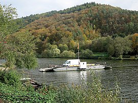
One of the few and traditional ferries on the Neckar connects Neckarhausen with the Baden-Württemberg Neckarhäuserhof on the other bank.
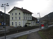
The route of the Neckar Valley Railway leads through the village. Here the S-Bahn RheinNeckar stops at the former train station and today's Neckarhausen stop (near Neckarsteinach) . The stop is served by the line that runs between Mosbach , Heidelberg , Mannheim and Kaiserslautern every half hour and on the extended line from Osterburken to Homburg (Saar) every hour.
literature
- Arthur Benno Schmidt : The historical foundations of civil law in the Grand Duchy of Hesse . Curt von Münchow, Giessen 1893.
- Georg Wilhelm Justin Wagner : Statistical-topographical-historical description of the Grand Duchy of Hesse: Province of Starkenburg . Volume 1. Carl Wilhelm Leske, Darmstadt 1829. [contains some factually inaccurate information]
Web links
- Districts of Neckarsteinach. In: Website of the city of Neckarsteinach.
- Neckarhausen, Bergstrasse district. Historical local dictionary for Hessen. In: Landesgeschichtliches Informationssystem Hessen (LAGIS).
- Neckarhausen. Local history, information. In: hessisch-neckarhausen.de. Private website
- Literature on Neckarhausen in the Hessian Bibliography
Remarks
Individual evidence
- ↑ a b c d Neckarhausen, Bergstrasse district. Historical local dictionary for Hessen. (As of October 16, 2018). In: Landesgeschichtliches Informationssystem Hessen (LAGIS).
- ↑ a b Selected data on population and households on May 9, 2011 in the Hessian municipalities and parts of the municipality. (PDF; 1.8 MB) In: 2011 Census . Hessian State Statistical Office
- ^ Neckarhausen, Bergstrasse district . In: LAGIS : Historical local dictionary ; As of October 16, 2018.
- ↑ Schmidt, p. 110.
- ↑ § 5 Reichsdeputationshauptschluss , there: "Amt Heidelberg".
- ^ Schmidt, p. 16, note 51.
- ^ Federal Statistical Office (ed.): Historical municipality directory for the Federal Republic of Germany. Name, border and key number changes in municipalities, counties and administrative districts from May 27, 1970 to December 31, 1982 . W. Kohlhammer, Stuttgart / Mainz 1983, ISBN 3-17-003263-1 , p. 348 .
- ↑ a b main statute. (PDF; 177 kB) § 5. In: Website. City of Neckarsteinach, accessed October 2019 .
- ^ Michael Rademacher: German administrative history from the unification of the empire in 1871 to the reunification in 1990. State of Hesse. (Online material for the dissertation, Osnabrück 2006).
- ^ Grand Ducal Central Office for State Statistics (ed.): Contributions to the statistics of the Grand Duchy of Hesse . tape 1 . Großherzoglicher Staatsverlag, Darmstadt 1862, DNB 013163434 , OCLC 894925483 , p. 43 ff . ( Online at google books ).
- ↑ a b List of offices, places, houses, population. (1806) HStAD inventory E 8 A No. 352/4. In: Archive Information System Hessen (Arcinsys Hessen), as of February 6, 1806.
- ^ Wagner, p. 164.
- ^ Ph. AF Walther : Alphabetical index of the residential places in the Grand Duchy of Hesse . G. Jonghaus, Darmstadt 1869, OCLC 162355422 , p. 60 ( online at google books ).
- ^ Wagner, p. 164.
- ^ Grein local council. In: website. City of Neckarsteinach, accessed December 2019 .
- ↑ Friends of the ferry Neckarhausen - Neckarhäuserhof eV

