Nenkersdorf (Netphen)
|
Nenkersdorf
City of Netphen
Coordinates: 50 ° 53 ′ 46 " N , 8 ° 11 ′ 35" E
|
|
|---|---|
| Height : | 362 (344-650.7) m above sea level NHN |
| Area : | 14.26 km² |
| Residents : | 412 (December 31, 2014) |
| Population density : | 29 inhabitants / km² |
| Incorporation : | 1st January 1969 |
| Postal code : | 57250 |
| Area code : | 02737 |
|
Main street in Nenkersdorf
|
|
Nenkersdorf is an east-southeast district of Netphen in the Siegen-Wittgenstein district in North Rhine-Westphalia . It has an area of 14.3 km² and 412 inhabitants (December 31, 2014).
geography
location
Nenkersdorf is located in the east of the Siegerland in the southern part of the Rothaargebirge , around six kilometers (km) east-southeast of the city center of Netphen. The two-part Gemarkung Nenkersdorf selected from the district area with the location (in the south west) and a beyond Walpersdorf located Exklave consists (in the northeast), is 14.26 square kilometers. It is between 344 and 650.7 m above sea level. NHN on the summit of the Jägerhain ; the village is at an altitude of 353 to 425 m . About 4.5 km northeast of the village lies the Siegquelle on Jägerhain . The Sehlbach and Sindernbach flow into the Sieg (in Nenkersdorf). Within the aforementioned exclave, in addition to the Siegquelle, there is also the Lahnquelle , located in the Lahnhof district of Nenkersdorf . Mountains in the area are: Hohe Hardt ( 517 m ), Auf den Plätze ( 509.4 m ), Nordhelle ( 579.9 m ) and Hellerkopf ( 551.8 m ).
Neighboring places
Neighboring towns of Nenkersdorf are Walpersdorf in the northeast, Lahnhof (to Nenkersdorf) in the east, Werthenbach in the southeast, Irmgarteichen and Helgersdorf in the south, Salchendorf and Grissenbach in the southwest and Beienbach in the west.
history
overview
Nenkersdorf probably emerged from forest forge settlements. In a document dated June 3, 1311, 4 tenants from "Nenkersdorph" are named. Bertold von Nenkersdorf is the first to be mentioned from Nenkersdorf. In a legend he owns a castle near Sieg and a ravine that led to the iron road of the Rothaargebirge . Through control lists population figures become visible: in 1461 there were 17 families in the village, in 1583 there were 25. In the years 1635 to 1642 raged in the plague , leaving 44 dead.
The first chapel was built in the village towards the end of the 15th century . It is said to have expired in 1552. Around 1600 the second chapel was built, which was a simultaneous chapel from 1651, but in 1750 no more services were carried out. A new chapel was used until 1955, it was demolished and replaced by a new one for the Protestant population of Nenkersdorf and Walpersdorf. On March 3, 1957, the fourth Catholic chapel in the village was inaugurated. In 1977 and 2005 Nenkersdorf won gold in the competition Our village should become more beautiful .
Until the end of 1968 the place belonged to the office of Netphen and became a part of the new large community of Netphen during the municipal reorganization on January 1, 1969, since 2000 a district.
Population numbers
Population of Nenkersdorf:
|
|
|
|
Lahnhof

location
The Lahnhof location is 3.5 km (as the crow flies ) east of Nenkersdorf on the Ederkopf-Lahnkopf ridge belonging to the Rothaargebirge on the Lahnkopf ( 624.9 m above sea level ) and on the Stiegelburg ( 640.9 m ) at around 602 to 620 m height. The source of the Lahn is on site ( Lahntopf ; approx. 603 m ); the sources of Eder and Sieg are a few kilometers away. By Lahnhof via the Lahn-Sieg-Eder run watershed leading Eisenstraße of the Rothaar , the Rothaarsteig and the European long-distance path E1 .
history
The property was first mentioned in a document dated March 28, 1333 under the name Lonebach - in a document that records feudal decisions of the von Hain family. It is assumed, however, that there was already a property at this location on an important north-south old street , Eisenstraße, in the Franconian - Carolingian times. The next documentary mention of the Lahnhof took place in the year 1336, according to the Siegener document book, when a "political conference" was documented in Lanebach in front of the Patschozer Walde , in which Count Otto von Nassau, Provost Heinrich von Speyer and Count Siegfried von Wittgenstein had participated .
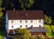
In the late 16th century, the Lahnhof was a count's farm yard, to which 17 meadows belonged according to a list of fiefdoms ; Pension bills from the Principality of Nassau-Siegen for the New Löhn-Hoff also exist from the 18th century . After 1807 the Lahnhof was incorporated into Nenkersdorf. In 1818 there were 12 residents in the Nenkersdorf-Lahnhof domain. After 1820 the old forester's house Lahnhof , which was believed to have risen in the basement of the Lahn, was demolished and replaced around 1828 by the construction of a two-story forest house with farm buildings.
Due to its pristine nature and the excellent view when the weather is nice, the Lahnhof has been a popular excursion destination for over 100 years.
Social and public institutions
- Evangelical Johanneskapelle
- Catholic Chapel of St. Barbara
- Hall Upper Siegtal
- BBQ hut
- sports ground
- Football field
- Children's playground
- Nenkersdorf & Lahnhof cemeteries
- Volunteer firefighter
Attractions
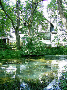
Interesting are within Nenkersdorf the village center and the Backhaus ( "Backes") as well as the Old water mill (see figure above) and outside the village of Lahnhof with the Lahn source (Lahn pot) at the Eisenstraße and the somewhat north of it located Siegquelle ; the river bed of the Sieg was adapted to the mill at an early stage.
traffic
Nenkersdorf is on Landesstrasse 719 ( Walpersdorf - Grissenbach ). With the motorway 45 is via terminals Wilnsdorf or wins over the Hüttentalstraße connected (HTS). The bus service is operated by Verkehrsbetriebe Westfalen-Süd (VWS).
literature
- Gerhard Scholl: In the headwaters of Sieg and Lahn. On the history of the eastern Siegerland. Gebrüder-Zimmermann-Verlag, Balve 1961.
Web links
- Website of the place
- Nenkersdorf on the Netphen website
- Nenkersdorf (Netphen) in the Westphalia Culture Atlas
Individual evidence
- ↑ a b c d Topographical Information Management, Cologne District Government, Department GEObasis NRW ( information )
- ^ Siegener Urkundenbuch, Volume I, Siegen , 1887, pp. 76–79, no. 125.
- ↑ Martin Bünermann: The communities of the first reorganization program in North Rhine-Westphalia . Deutscher Gemeindeverlag, Cologne 1970, p. 71 .
- ^ Otto Schaefer: The district of Siegen , Siegen 1968
- ↑ Westfälisches Gemeindelexikon 1887, pp. 110/111
- ↑ Westfälisches Gemeindelexikon 1897, pp. 112/113
- ↑ gemeindeververzeichnis.de: District of Siegen
- ↑ genealogy.net: Office Netphen
- ↑ a b Michael Rademacher: German administrative history from the unification of the empire in 1871 to the reunification in 1990. City and district of Siegen. (Online material for the dissertation, Osnabrück 2006).
- ↑ Martin Bünermann, Heinz Köstering: The communities and districts after the municipal territorial reform in North Rhine-Westphalia . Deutscher Gemeindeverlag, Cologne 1975, ISBN 3-555-30092-X , p. 226 .
- ↑ Bernhard Oltersdorf: Netphen ( Memento of the original from March 7, 2014 in the Internet Archive ) Info: The archive link was inserted automatically and has not yet been checked. Please check the original and archive link according to the instructions and then remove this notice. (PDF; 9.0 MB) , approx. 1995
- ↑ a b Gerhard Scholl: On the history of the Lahnhof . In: Siegerland - sheets of the Siegerländer Heimatverein e. V., Volume 36, Issue 2, pp. 63-67. Wins 1959


