
New way (Bayreuth)

Neuer Weg is the historical name for the former expansion of the city of Bayreuth north of the Red Main .
Surname

The name goes back to a street that is mentioned in the first town book from the 15th century: "After Christ purt one thousand four hundred and in the forty-fourth jare the road was paved outside the Rotmayn on Neuenweg by the zygelhutten". The name of the district, which was in use until the 20th century, developed from this.
location
The Neuer Weg district originally comprised roughly the area between the river, Friedrich-Puchta-Strasse, Carl-Schüller-Strasse and Bahnhofstrasse. This article also covers the adjacent areas of the Bahnhofsviertel, Spinnereiviertel and the area around Wilhelmsplatz.
History and description


The suburb of Neuer Weg was probably built in the 14th century. It provided living space for poor and socially disadvantaged groups in particular. The building structure was accordingly not very spectacular. The construction of the nearby spinning mills brought many factory workers to the area in the second half of the 19th century. For decades it had a strong neighborhood identity. The sociable association "Neia Wecha Gma" (New Weger Municipality) organized the annual festival called "Neia-Wecha-Kerwa".
Located in the floodplain, the Neue Weg was always at risk of flooding. The flood disasters of 1907 and 1909 were the reason for the regulation of the Main between 1913 and 1916. The river bed was widened and canalized. With the construction of the city center ring, it partially disappeared under a concrete ceiling in 1968/69, whereby the Ludwigsbrücke, built on the site of the New Kasernbrücke in 1904/05, was demolished.
During the first air raid on the city on April 5, 1945, the area was the target of US bombs. The area around Wilhelmsplatz in particular was severely damaged in the course of two waves of attacks at 10.30 a.m. and 11.30 a.m., seven firefighters were killed in action there. Entire rows of houses were also destroyed in Goethestrasse, Friedrich-von-Schiller-Strasse and Nibelungenstrasse, as was the first station building from the 1850s. One of the few houses on the north side of Mainstrasse with the Frühhaber restaurant (since 1989 jazz bar “Podium”) on the north side of Mainstrasse was torn down in 2012.
The houses between Mainstrasse and the Red Main were demolished in the 1970s. The Kammer-Lichtspiele cinema existed from 1925 to 1997 at Schulstrasse 15. In the house at Schulstrasse 26 was the Open Youth Center from 1974 to 1982, an institution that was run by the young people who frequented it in self-administration.

Meadow road

Glance into Brunnenstrasse
Mainstrasse with the building of the former Frühhaber restaurant, which was demolished in 2012 (right)


Bahnhofsviertel

The Bahnhofsviertel was accessed via the Neue Kasernbrücke, built in 1752, which connected the section of Jägerstrasse south of the Red Main (since 1889: Luitpoldplatz) with the northern section (since 1889: Bahnhofstrasse). In 1904/1905 it gave way to the Ludwigsbrücke, which existed until 1968. Since then, the busy Annecyplatz has been located there, which from today's perspective is counted among the "building sins of urban planning".

The station building of the main train station dates back to 1879, its predecessor, which was still used by the post office, was bombed in 1945. On April 11, 1945 between 2:53 p.m. and 3:03 p.m., 110 aircraft of the 4th bomber group of the British Bomber Command attacked the city, which had already been badly damaged by two previous attacks. Due to its location around the main train station and in the axis between the large spinning mills converted into armaments factories, the station district was largely destroyed.


On Bahnhofstrasse (before 1889 Jägerstrasse), the ruins of the once eponymous Jägerhaus , built in 1760 according to plans by Carl von Gontard, were demolished in 1954 , which, according to city historian Bernd Mayer , "began the second destruction of the city". In 1956 the “Filmpalast” cinema was opened at the site. The city's largest movie theater at the time, with 900 seats, only existed for a few years; in 1970 the building was sold to a bank.
To the south of it, on the right-hand side, was the sandstone building of the Main Barracks, completed in 1739 , which did not survive the bombardment of April 1945. Margrave Christian Ernst had the first barracks built there in 1601, under Friedrich III. In 1740 a new building was built according to plans by Johann Friedrich Grael . After the garrison was relocated to the newly created barracks district in the late 19th century , the Main barracks served as a residential building for poor families. In its place is now the New Kolping House , built in 1959/60 , which in the meantime served as a hotel and now houses a day-care center and student apartments. The light installation Glowworm Fire Salamander by the artist Roland Schön has been on the roof of the building since 2011 .

Before that, in the former barracks yard, the first traffic kindergarten in Bavaria was inaugurated in early June 1959. There school children were able to practice “correct traffic behavior” in pedal cars and on bicycles . The system, which was provided with asphalt roads, traffic signs, markings and an intersection secured by traffic lights, had to give way to parking spaces when the Red Main was capped at the end of the 1960s.
East of it, the first public indoor swimming pool opened on December 14, 1929. In addition to the indoor swimming pool with a 25 by 10 meter pool, it had a bathtub department as well as a "Roman-Irish bath" with a hot air room, steam room and two plunge pools. The architecturally outstanding Art Nouveau building was built according to the most modern aspects with reinforced concrete arches . The bath was closed from April 1945 to November 1949 because the boiler house had been damaged in the bombing. In the 1990s it was completely renovated and put back into operation in 1996, the former Roman-Irish area is now operated as a sauna department.
Numerous restaurants and hotels have established themselves in Bahnhofstrasse. With restaurants, shops for short-term needs (bakers, butchers) and a few specialty shops, it is one of the city's secondary shopping streets.

Gasthaus “Zum golden Schwan” (Bahnhofstrasse 1), destroyed in a bombing raid in 1945

Gasthof zum golden Hirschen, Bahnhofstrasse 13, around 1910
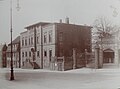
Villa of the banker Friedrich Feustel , Bahnhofstrasse 15, on the right Eisenhandlung Bauer, both destroyed in April 1945
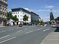
Station square with facade climbers on the buildings of the Chamber of Industry and Commerce for Upper Franconia


Wilhelmsplatz

The Wilhelm square was built in the 1880s and after the German Emperor I. Wilhelm named. In the middle of the circular square was a planted roundabout with a tall street lamp. In the second half of the war , a water basin was built in its place, which was supposed to hold water for fire fighting in the event of bombing raids. The well located there today comes from the post-war period.
The square was lined with multi-story Wilhelminian-style buildings, more than half of which were destroyed during the bombing raids in April 1945. On the northeast side, a Protestant church was built on the site of a residential building between 1953 and 1956 . Until then, the Neue Weg belonged to the parish of Sankt Georgen , and all those who died north of the Red Main were buried in the local cemetery. The Christ Church with its three towers became a new landmark of the district.
Friedrich-von-Schiller-Strasse and the street Karl-Marx-Strasse - Nibelungenstrasse cross at Wilhelmsplatz, and Goethestrasse branches off to the northeast. The Martin Wirsing sugar factory was located between Goethestrasse and Friedrich-von-Schiller-Strasse. After the bombing raid in 1945 it was soon rebuilt and produced until 1965. Today there is a parking lot for the post office.
Spinning Quarter

The Spinnereiviertel owes its origin to the New Cotton Spinning Mill from 1889 on its western edge , to which another spinning mill ( F. C. Bayerlein ) was added in 1894 . The two large multi-storey spinning mills formed the largest industrial area in the city for a long time. During the Second World War, slave laborers worked there for the armaments industry , and in 1944 a satellite camp of the Flossenbürg concentration camp was set up on the grounds of the New Cotton Spinning Mill .
Both businesses have since gone out, only one of the buildings has been preserved, restored and converted. There and on the vacated areas, businesses, medical practices, the employment office and a hotel have settled. 1988 drew fire brigade from their old guard in the city center in its new home on the rear grounds of the new cotton-spinning mill.
The housing cooperative Bauverein Bayreuth, founded on August 31, 1903, erected its first two buildings in 1904 with the houses at Gutenbergstrasse 5 and 7. The architecturally remarkable building association houses at Friedrich-Schiller-Strasse 20–22 from 1922 have also been preserved. On Friedrich-Puchta-Strasse there are buildings from the Wilhelmine era , several of which have the character of villas . On Casselmannstrasse there are houses with company apartments from both spinning mills, some of which were built before the First World War and some in the 1920s.
traffic


The busiest axes are the Bahnhofstrasse - Bürgerreuther Strasse and Casselmannstrasse - Gutenbergstrasse. Both run in a north-south direction and are served by city bus routes. The former main axis along the lower Schulstrasse and Karl-Marx-Strasse is only of secondary importance. The east-west axis is Carl-Schüller-Strasse from Bahnhofstrasse to Berliner Platz. In 1985, the north ring was completed as a tangent north of the spinning mill site. It initially connected Hindenburg Street with Meistersingerstraße and became a main artery when it opened in 1994 when it continued towards the Sankt Georgen industrial area (Hofer Straße).
From Bahnhofstrasse, Tunnelstrasse branches off to the east; it takes its name from an underpass under the railway tracks to Weiden and Nuremberg . Since 1904 , the main street in the Sankt Georgen district has replaced a level crossing that crossed numerous tracks at the southern head of the station. Until Albrecht-Dürer-Strasse was built, it was also part of Bundesstrasse 2 .
The main public transport hub is the main train station with its numerous bus stops. At the Bahnhofsplatz and in the nearby Goethestrasse, bus routes of the Greater Nuremberg Transport Association (VGN) operate in city and regional traffic. Long-distance buses from various companies also stop several times a day , mainly on the Berlin – Munich route.
Todays situation
The Allied bombings in 1945 hit the area very hard. Demolitions and new buildings in the post-war period have also changed its appearance significantly.
Remarks
- ↑ Kerwa = parish fair , but the New Way did not have its own church.
- ↑ The name is emphasized on the second syllable: Tunn el .
literature
- Kurt Herterich: From the Bayreuth castle tower to the festival hill . Ellwanger, Bayreuth 2003, ISBN 978-3-925361-47-0 .
- Herbert Popp: Bayreuth - rediscovered . Ellwanger, Bayreuth 2007, ISBN 978-3-925361-60-9 .
Web links
- Danger of flooding - the fate of the bridge at Annecyplatz with photos of the flood disasters in the Neuer Weg
Individual evidence
- ↑ Rosa and Volker Kohlheim: Bayreuth's street names from the Middle Ages to today . In: Historischer Verein für Oberfranken (Hrsg.): Archive for the history of Upper Franconia 86th volume . Ellwanger, Bayreuth 2006, p. 57 ff .
- ^ Herbert Popp: Bayreuth - rediscovered . Ellwanger, Bayreuth 2007, ISBN 978-3-925361-60-9 , pp. 120 .
- ↑ a b c d e f Herbert Popp: Bayreuth - newly discovered , p. 122 ff.
- ↑ Bernd Mayer: Bayreuth in the twentieth century , p. 119.
- ↑ Udo Meixner: 70 years of the end of the war. Bayreuth and the surrounding area . 1st edition. Nordbayerischer Kurier, Bayreuth 2015, ISBN 978-3-944791-53-1 , p. 10 ff .
- ↑ 75 years of the end of the war in: Nordbayerischer Kurier of April 6, 2020, p. 10.
- ↑ The music played here on kurier.de on October 31, 2012, accessed on April 6, 2020
- ↑ Stadthaus an der Mainstraße celebrates the topping-out ceremony in: Nordbayerischer Kurier from May 19, 2015, p. 11.
- ↑ Bernd Mayer: Bayreuth in the twentieth century , p. 126.
- ↑ Kammer-Lichtspiele at allekinos.com, accessed on November 30, 2014
- ↑ "We were a provocation" in the North Bavarian Courier of October 30, 2014, p. 11.
- ^ Kurt Herterich: From the Bayreuth Castle Tower to the Festival Hill , p. 78 f.
- ↑ a b c d Herbert Popp: Bayreuth - newly discovered , p. 120.
- ↑ Peter Engelbrecht : The war is over . Druckkultur Heinz Späthling, Weißenstadt 2015, ISBN 978-3-942668-23-1 , p. 28 ff .
- ↑ Kurt Herterich: From Bayreuth Castle Tower to Festival Hill , p. 97.
- ↑ Arno Kröniger : Bareith is copper! Akron, Bayreuth 2011, ISBN 3-9808215-6-0 , p. 19 .
- ↑ Bernd Mayer: "Architectural monuments - annihilated forever" in the Heimatkurier des Nordbayerischer Kurier, 2/2005, p. 7.
- ↑ Bayreuth Filmpalast at filmtheater.square7.ch, accessed on April 6, 2020
- ↑ Kurt Herterich: From Bayreuth Castle Tower to Festival Hill , p. 113.
- ↑ 50 years ago in: Nordbayerischer Kurier of June 5, 2020, p. 8.
- ↑ Arno Kröniger: Bareith is copper! , P. 27.
- ↑ a b Kurt Herterich: From Bayreuth Castle Tower to Festival Hill , p. 105.
- ↑ a b Herbert Popp: Bayreuth - newly discovered , p. 119.
- ↑ Kurt Herterich: From Bayreuth Castle Tower to Festival Hill , p. 106.
- ↑ Kurt Herterich: From Bayreuth Castle Tower to Festival Hill , p. 131.
- ↑ Arno Kröniger: Bareith is copper! , P. 17.
- ↑ Rosa and Volker carbon home: Bayreuth from AZ. Lexicon of Bayreuth street names . Rabenstein, Bayreuth 2009, ISBN 978-3-928683-44-9 , pp. 119 .
- ^ Kurt Herterich : From Bayreuth Castle Tower to Festival Hill . Ellwanger, Bayreuth 2003, ISBN 3-925361-47-2 , pp. 146 .
- ^ Herbert Popp: Bayreuth - newly discovered , p. 128.
- ↑ Arno Kröniger : Bareith - where you look! 1st edition. Akron, Bayreuth 2007, ISBN 3-9808215-4-4 , pp. 51 f .
- ↑ Kurt Herterich: From Bayreuth Castle Tower to Festival Hill , p. 148.
- ^ Rainer Trübsbach : History of the City of Bayreuth. 1194-1994 . Druckhaus Bayreuth, Bayreuth 1993, ISBN 3-922808-35-2 , p. 337 .
- ↑ Bernd Mayer: The Bauverein makes city history in: 90 Years Bauverein Bayreuth, p. 11.
- ↑ Bernd Mayer: The Bauverein makes city history in: 90 years Bauverein Bayreuth, p. 18 f.

Aichig | Old town * | Peasant green | Farms | Bayreuth ( historic city center ) | Birch trees * | Floor mill | Castle * | Bürgerreuth * ( Green Hill ) | Colmdorf | Destuben | Dörnhof | Dürschnitz * | Eichelberg | Hermitage | Hermit Court | Frankengut | Friedrichsthal | Prosecution | Garden City * | Vulture's Nest | Geigenreuth | Bell * | Grunau | Grunauermühle | Green tree * | Hammerstatt * | Heinersberg | Hermannshof | Hollow mill | Hölzleinsmühle | Hornsröth | Hussengut | Juchhöh | Karolinenhöhe | Karolinenreuth | Barracks district * | Cross * | Cross stone | Krodelsberg | Krugshof | Laimbach | Laineck | Latvians | Tan | Meyernberg | Meyernreuth | Moss hill | Moritzhöfen * | Mosing * | New home * | New way * | Upper Röth | Oberkonnersreuth | Oberobsang | Oberpreuschwitz | Oberthiergarten | Opelsgut | Oschenberg | Pfaffenfleck | Plantation | Powder mill | Püttelshof | Riedelsgut | Rödensdorf | Rodersberg | Rollwenzelei | Römerleithen | Römersberg | Red Hill * | Saas | St. Georgen * | St. Johannis | Shooting house | Schlehenberg | Schlehenmühle | Schupfenschlag | Seulbitz | Worry Flee | Spinning Quarter | Southwest city center * | Devil's Trench | Thiergarten | Lower Röth | Unterpreuschwitz | Fulling Mill | Weiherhaus | Wendelhöfen | Meadows | Wolfsbach | Wunau | Wondrous good
* none of the official 74 districts