Nowy Port (Russia)
| Village
Nowy Port
Новый Порт
|
||||||||||||||||||||||||||||||||||||
|
||||||||||||||||||||||||||||||||||||
|
||||||||||||||||||||||||||||||||||||
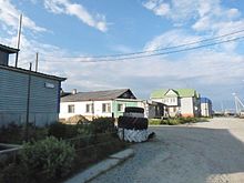
Nowy Port ( Russian Новый Порт ) is a village (selo) in the Yamal-Nenets Autonomous Okrug in Russia with 1720 inhabitants (as of October 14, 2010).
geography
The place is about 300 km as the crow flies northeast of the district administrative center Salekhard in the southeastern part of the Yamal Peninsula north of the Arctic Circle . It is located on the western bank of the Obbusen , which is about 60 km wide there , the extended confluence of the Ob into the Kara Sea , at a bay also called Nowy Port ("New Harbor"). On the opposite bank of the Obbusen, a little further north, is the Jamburg natural gas workers' settlement .
Nowy Port belongs to the Yamalsky district and is about 130 km to the northeast from its administrative center Jar Sale . It is the seat and only locality of the rural community (selskoje posselenije) Selo Nowy Port. Over 80% of the residents are Nenets .
history
The place goes back to a transshipment point that was established there in the early 1920s as part of the development of the Northern Sea Route . The first permanent buildings were erected in the summer of 1921. In 1928 a trading post opened for trade with the semi-nomadic indigenous inhabitants of the area, and from 1930 fishing facilities such as a small port and a canning factory were established. From 1931, in the course of the deculakization under Stalin, farmers from southern parts of the country were deported to Nowy Port as so-called “special resettlers ” (Spezperesselenzy) . These were the first permanent residents of the settlement. The forced relocations to Nowy Port continued into the 1940s, including from 1941 by Volga Germans .
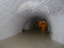
At times there were administrative organs of the Jamalski rajon, founded in 1930, and of the Baidarata-ITL labor camp (also called Baidarlag ) in the Gulag system in 1948 . From 1950, mainly by prisoners and forced laborers, a system of tunnels and rooms for the storage of up to more than 1700 tons of fish was built in the permafrost ground 12–13 meters below the surface of the earth, virtually without technical aids. The temperature in the Merslotnik (roughly "freezer"), which covers an area of about one hectare, is −12 to −17 ° C all year round. By 1956, the work was largely complete. Today one of the three main tunnels is still used according to its original purpose.
Nowy Port initially had the status of a settlement (possjolok), since the municipal reform in 2005 it has been run as a village (selo) .
traffic
Nowy Port is a port on the Northern Sea Route, which is primarily used as a transshipment point for river navigation on the Ob and in the direction of the Tasbusen and the Tas and Pur rivers that flow into it , as well as to supply the oil and gas condensate fields in the hinterland of the village and the Removal of their products. Since the 1990s, however, the port's importance has declined overall in favor of the ports further north, closer to the region's most important natural gas fields , Mys Kamenny , almost 100 km away, and Sabetta , 450 km away , which is being expanded.
The village is served by helicopter from Yamal Airlines all year round . In summer it can also be reached by hydrofoil from Salekhard, the journey takes about ten hours, depending on the weather conditions. Since the harbor is not deep enough for these ships, a push boat is anchored in the obbus a few hundred meters from the village. From there, the passengers are transferred to the shore in smaller boats.
Nowy Port, on the other hand, is not connected to the year-round road network. A winter track leads to the village, which starts from Labytnangi and follows partly on the ice of the Ob or its tributaries past the Rajon center of Jar-Sale on the southeast coast of the Jamal peninsula.
The Obskaya – Karskaya railway line , which was built between the 1980s and 2010s and opens up the natural gas fields in the central part of Yamal, runs a good 100 km to the west . There are plans to build a branch line from Pajuta Station to Nowy Port, but the priority connection from Sabetta further north is preferred.
Web links
Individual evidence
- ↑ a b Itogi Vserossijskoj perepisi naselenija 2010 goda. Tom 1. Čislennostʹ i razmeščenie naselenija (Results of the All-Russian Census 2010. Volume 1. Number and distribution of the population). Tables 5 , pp. 12-209; 11 , pp. 312–979 (download from the website of the Federal Service for State Statistics of the Russian Federation)
- ↑ Baidarata-ITL in the GULAG Internet portal of Memorial Deutschland e. V.


