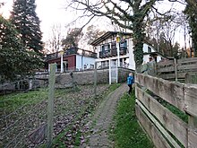
Upper State (Engelskirchen)
|
Upper State
Municipality Engelskirchen
Coordinates: 50 ° 58 ′ 34 ″ N , 7 ° 19 ′ 58 ″ E
|
||
|---|---|---|
| Height : | 182 m above sea level NHN | |
| Postal code : | 51766 | |
| Area code : | 02263 | |
|
Location of Oberstaat in Engelskirchen |
||
Oberstaat is a place in the municipality of Engelskirchen in the Oberbergisches Kreis in North Rhine-Westphalia in Germany .
Location and description
The place is located in the southwest of Engelskirchen on the border with the Rheinisch-Bergisches Kreis and the municipality of Lindlar in the Agger valley . Neighbors are Ehreshoven with Ehreshoven Castle , Unterstaat , in the area of Lindlar Hohkeppel and in the area of the city of Overath the places Unterhasbach and Vilkerath .
In Oberstaat there is not only a lot of forest, some old half-timbered houses and the Bergische Schweiz excursion restaurant with a game gate and hotel, but also a modern clay conference center, EcoLut.
history
In the Prussian first recording from 1845, the place is recorded under the designation "State" . From 1896 the topographic maps show the place name Oberstaat. The Overather house numbering cadastre from 1907 lists a house owned by Countess v. Nesselrode with the resident Ferdinand Rasch.
Individual evidence
- ↑ Topographical Information Management TIM-online, provided by the Cologne District Government
- ^ Historika25, State Surveying Office NRW, sheet 5009, Overath
- ^ Historika25, State Surveying Office NRW, sheet 5010, Engelskirchen
- ^ Berthold Gladbach, Peter Lückerath: The Overather population in lists of names, taxes and residents from the 15th to the 20th century, p. 370. Ed .: Geschichtsverein Rhein-Berg, Bergisch Gladbach 2016. ISBN 978-3-932326-75 -2


