Wendelstein (mountain)
| Wendelstein | ||
|---|---|---|
|
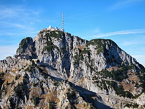
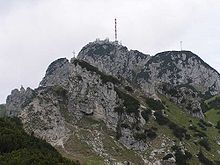
The Wendelstein from the south |
||
| height | 1838 m | |
| location | Bavaria | |
| Mountains | Mangfall Mountains , Bavarian Prealps | |
| Dominance | 6.58 km → Großer Traithen | |
| Notch height | 740 m ↓ Sudelfeld | |
| Coordinates | 47 ° 42 '10 " N , 12 ° 0' 44" E | |
|
|
||
| rock | Wetterstein lime | |
| Age of the rock | Triad | |
| First ascent | unknown | |
| Development | ||
| particularities | heavily built up and developed | |
The Wendelstein is a 1838 m high mountain in the Bavarian Alps . It belongs to the Mangfall Mountains , the eastern part of the Bavarian Prealps. It is the highest peak of the Wendelstein massif. Because of its exposed location, it offers a very good view of the Bavarian Alpine foothills and, conversely, can be seen from a wide area. It lies between the river valleys of Leitzach and Inn . It is accessible with the Wendelstein cable car and the Wendelstein rack railway. The Jenbach rises at its northern foothills and becomes Kalten on its way to the Mangfall .
At the summit, the borders of the municipalities of Bayrischzell (south), Brannenburg (northeast) and Fischbachau (northwest) meet. Valley locations include Bayrischzell, Brannenburg (rack railway) and Osterhofen (municipality of Bayrischzell, cable car).
geography
geology
The mountain consists mainly of Wetterstein limestone from the Upper Triassic with Dasycladaceae - these are marine algae whose habitat is flat lagoons in tropical climates. The color of the rock varies between gray-white and light gray to speckled.
climate
The annual precipitation is 1713 mm in the reference period 1961–1990 and is extremely high in a Germany-wide comparison because it falls in the upper twentieth of the values recorded in Germany. Lower values are registered at 99% of the measuring stations of the German Weather Service . In the period from 1971 to 2000, annual precipitation fell by around 40 mm compared to the normal period. Most of the precipitation falls with 199 mm in July and thus about 2.6 times as much as in the driest month, October. The seasonal fluctuations are extremely large. Higher seasonal fluctuations are registered at only three percent of the measuring stations. Due to its exposed location, the Wendelstein often has very high wind speeds - especially when there is a foehn . The record measured during hurricane Lothar is 259 km / h.
|
Climate data for Wendelstein weather station
Source: Average temperatures: "Monthly average temperatures 1961-90, 10980 Wendelstein" from http://www.dwd.de/klimadaten (ZIP file; 47 kB)
Precipitation: "Monthly precipitation sums 1961-90, 10980 Wendelstein" from http: / /www.dwd.de/klimadaten (ZIP file; 341 kB) hours of sunshine: "Monthly sunshine duration 1961-90, 10980 Wendelstein" from http://www.dwd.de/klimadaten (ZIP file; 41 kB) |
||||||||||||||||||||||||||||||||||||||||||||||||||||||||||||||||||||||||||||||||||||||||||||||||||||||||||||||||||||
Development
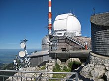
On the top of the mountain there is a rich infrastructure with the Wendelstein Chapel, an observatory , a former weather station and a widely visible transmission system of the Bavarian Broadcasting Corporation as well as numerous other telecommunications transmission / antenna systems. About a hundred meters below the summit, on the plateau between Wendelstein and Schwaigerwand, are the mountain inn, the end stations of the cogwheel railway and cable car, the operating buildings of the transmitter, the former mountain hotel (above the train station), a mountain rescue service and the well-known Wendelstein church .
The buildings around the mountain stations are connected to the 100 m higher summit via a paved path, which makes the summit accessible even to inexperienced hikers with numerous stairs and serpentines . Since the path cannot be used in winter, there is an elevator in the middle of the mountain for employees of the observatory, weather service and transmitter, which can be reached via a tunnel from the cog railway station.
The rack railway built by Otto von Steinbeis in 1912 is the oldest still in operation in Bavaria. Since its renovation at the beginning of the 1990s, modern rack-and-pinion railcars have been running on it, reducing travel time from 55 minutes to around half an hour.
The well-developed Wendelstein cave with some stalactite stones in which ice lingers well into summer is located near the top station of the rack railway .
Various paths around the Wendelstein are signposted as a Geopark .
The beautiful panoramic view from the summit and the easy accessibility with the two mountain railways have made the Wendelstein one of the most famous and popular mountains in the Bavarian Alps, despite its relatively dense development. The mountain top is also easily accessible on foot. The path that starts at the valley station of the Wendelsteinbahn in Bayrischzell -Osterhofen takes around three hours to walk to the summit.
Wendelsteinkircherl and Wendelstein chapel
On July 1, 1889, the foundation stone for the Wendelsteinkircherl was laid on the Schwaigerwand, a rocky ridge a hundred meters below the summit. The initiator was the Munich art professor Max Kleiber. On August 20, 1890, the highest church in Germany to date was consecrated. It is dedicated to the Patrona Bavariae and is run by the Archdiocese of Munich and Freising as a side church of the parish Maria Himmelfahrt in Brannenburg. A comprehensive renovation took place in 2016/17. The Wendelstein-Kircherl bears the undisputed designation of the “highest church in Germany” - all higher churches (such as the Zugspitz Chapel, consecrated in 1981) are not churches in the sense of canon law , but only chapels . Masses and weddings take place regularly in the mountain church in summer.
The Wendelstein church is often referred to as a chapel or Wendelstein chapel - this is not only wrong in the canonical sense, but also misleading, because there is actually a Wendelstein chapel in addition to the Wendelstein church. This is consecrated to St. Wendelin and stands directly on the summit. This summit chapel , a small wooden structure, was built in 1718 by the farmer Georg Klarer from the Sixten farm in Bayrischzell as a votive chapel for the recovery of his two horses that were lost in the fog on the mountain pastures. The chapel's patronage was probably chosen because Wendelin is venerated as the patron of cattle. The name of the mountain "Wendelstein" is partly associated with the Wendelin patronage of the chapel. Since 1989, the maintenance of the small Wendelin chapel at 1,838 meters has been the responsibility of the Upper Bavarian mountain riflemen . In May 2018, the three hundredth anniversary of the Wendelin Chapel was celebrated.
Mountain weather station and observatory
At the summit of the Wendelstein there was a meteorological station operated around the clock by the German Weather Service until 2012 , and there is still an observatory of the Institute for Astronomy and Astrophysics of the Ludwig Maximilians University in Munich . With an average of over 120 clear nights a year, the Wendelstein location in Germany is particularly predestined for such systems.
The first weather observations were made on the Wendelstein in a provisional observatory at the summit chapel by Paul Schiegg from July 1804, but the recordings were often thwarted by thunderstorms , storms , snow and rain . In 1883 Fritz Erk from the royal Bavarian meteorological central station in Munich built the Wendelsteinhaus meteorological station at an altitude of 1700 m, the first alpine station in the royal Bavarian meteorological station network. The mail was carried to and from this station in winter by the members of the Wendelsteinhaus Alpine Club and in summer by tourists. Today's weather station was built on the summit in 1962 and was staffed with full-time staff around the clock. After 130 years of uninterrupted weather monitoring, the German Weather Service decided to give up the station on September 21, 2012 for cost reasons. This ended the weather records on Wendelstein.
The observatory was founded in December 1939 by Karl-Otto Kiepenheuer as a solar observatory for the Air Force of the Wehrmacht . By observing solar activity, it should be possible to predict the optimal frequencies for military radio communications as precisely as possible . After the Second World War , the observatory was funded by the US armed forces for the same purpose. The facility has belonged to the University of Munich since 1949. In the sixties the observatory was expanded to include a coronograph; With this device, the solar atmosphere could now also be researched. Because of increasing air pollution and a shift of the research focus towards night astronomy, scientific solar observation was discontinued in the 80s. Since 1988 the facility has been a pure observatory; the dome of the coronograph is only used for illustrative purposes today. First of all, an 80 cm mirror telescope and CCD cameras were used from Wendelstein to search for extrasolar planets by evaluating star coverages and to search for variable stars in dwarf galaxies . On May 21, 2012, the 80 cm telescope was replaced by the Fraunhofer telescope , an instrument with a two meter opening.
In addition, there was an observatory on the eastern summit of the Wendelstein from 1950 to 1960, consisting of an observation dome and a residential building. The astronomer Rudolf Kühn conducted research there . The facility was completely demolished around 1965, only remnants of the foundations are still visible today. In the place where the observation dome used to be, a wind turbine was later installed, but it was dismantled in 2007.
In addition to today's observatory are also three amateur radio - relay stations in the 2-m , 70-cm and 23-cm band operated.
Ski Area
The Wendelstein cable car , the Wendelstein cog railway and two drag lifts open up a small but challenging ski area . Plans to establish a connection to the Sudelfeld ski area were discarded. Because of a legal dispute with an alpine farmer, skiing on Wendelstein was suspended from 1995 to 1997.
Despite numerous blasts and other construction work in the past 40 years, most of the slopes on Wendelstein are steep, steep slopes that are only suitable for experienced skiers. The “most feared” descent is the east descent , which leads from the terminus of the Lacherlift to the Mitteralm . This descent overcomes a height difference of 500 m over a length of 3.8 km. Similarly difficult, albeit only a few hundred meters long, is the descent over the so-called hotel slope , which opens up the actual ski area from the end stations of the two mountain railways - every skier has to go through here, even if his goal is the somewhat easier runs around the Wendelstein Almen are. The Lacherlift, which opens up the east run, also begins at the Wendelsteinalmen. The descent from the hotel slope to the Wendelsteinalmen leads past the so-called crematorium , a rock face that is exposed to the blazing sun when the weather is nice. This is why the place was previously used by skiers for sunbathing and tanning - just to "burn corpses", hence the macabre name. In the further course there are two possibilities: a steep slope and the slightly easier variant via " Davos " - "there where it" is easier, as the saying goes.
Others
- 1916–1917, the Maybach-Motorenbau company built an engine test bench for the high-altitude engine Mb IVa on the Wendelstein . The engine was u. a. Used in Zeppelin airships and in the Rumpler long-range reconnaissance aircraft C.VI and C.VII .
- In 1981 the episode Die Bergtour of the series Meister Eder and his Pumuckl played on the mountain and in the Wendelsteinbahn.
- In 2005 several scenes of the comedy Who dies earlier is longer dead were filmed on the top of the mountain.
- In 2010, the Wendelstein served next to the Kitzbüheler Horn under the name Engelstein as a backdrop and location for the ZDF television thriller Tod am Engelstein .
- The stellarator experiments of the Max Planck Institute for Plasma Physics , which took place in Garching near Munich in Bavaria , are named after the Wendelstein mountain. As early as the end of the 1950s, this mountain was chosen as the namesake of the German stellarators, based on the early, up to 1959 secret US stellarator project "Matterhorn" in Princeton. This name was also retained for the current experiment, Wendelstein 7-X in Greifswald .
See also
literature
- Max Kleiber: How the Wendelstein Church was created. A look back at the years 1888–1922. Upper Bavarian Printing House, Rosenheim June 1922.
Web links
Individual evidence
- ↑ Geological map of Bavaria with explanations (1: 500,000). Bavarian Geological State Office, 1998.
- ↑ http://www.klimadiagramme.de/Deutschland/wendelstein2.html
- ↑ Description of the mountain tour to the Wendelstein summit at hoehenrausch.de
- ↑ Susanne Sasse: Wendelstein: highest church in Germany reopened . In: Merkur.de , June 11, 2017. Retrieved June 12, 2017.
- ↑ https://www.wendelsteinbahn.de/geschichte-des-wendelsteins , accessed on September 6, 2018.
- ↑ Wendelinkapelle on the Wendelstein celebrates its 300th birthday , br.de from May 25, 2018
- ↑ http://www.wetteronline.de/wotexte/redaktion/topthemen/2012/10/1002_ws_Alpenwetterwarte-endet.htm
- ^ University observatory Munich: history
- ↑ Kyrill von Gersdorff, Helmut Schubert, Stefan Ebert: Aero engines and jet engines. 4th edition, Bernard & Graefe Verlag, 2007, p. 35.
- ↑ Filming locations Whoever dies earlier is longer dead on bayerische-kultserien.de, accessed on August 31, 2019
