
Reelkirchen
|
Reelkirchen
City of Blomberg
Coordinates: 51 ° 54 ′ 51 ″ N , 9 ° 1 ′ 41 ″ E
|
|
|---|---|
| Height : | 192 m above sea level NN |
| Area : | 3.99 km² |
| Residents : | 733 (Dec 2010) |
| Population density : | 184 inhabitants / km² |
| Incorporation : | January 1, 1970 |
| Postal code : | 32825 |
| Area code : | 05235 |
 Location of Reelkirchen in Blomberg
|
|

Reelkirchen ( Low German : Reelkerken ) is one of the 19 localities in the city of Blomberg in the Lippe district in North Rhine-Westphalia . The village is located about eight kilometers southwest of the city center directly on federal highway 1 and borders directly on the Herrentrup district . In 2010 Reelkirchen had 733 inhabitants on a municipality area of 3.99 km², which corresponds to a population density of 191 inhabitants / km².
Geographical location
Reelkirchen is around eight kilometers southwest of Blomberg. Bad Meinberg with its parks is around four kilometers away. Reelkirchen is located in the Blomberg Basin at 192 m above sea level and is framed by the south-eastern foothills of the Lippe Mountains in the northeast and the foothills of the Teutoburg Forest / Eggegebirge in the southwest. The highest point of the place is the Spielberg at 239 m above sea level, which offers a panoramic view of the entire Blomberg basin.
history
The earliest documented mention of Reelkirche as Reilegenkerken comes from 1194. It is unclear whether the name comes from a monastery church called Regula or from a landlord called Reyling . The church at Relinkerke , which belongs to the church administration Steinheim, is mentioned as early as 1231 . The village itself is likely to be much older. As early as the 9th century, the parish Reelkirchen was a mission center and original parish for the entire Blomberg basin .
In 1344 an office Relenkerken is mentioned. The first owners of a fief in Reelkirchen were the ways , followed by the von Klingen family . Around 1550 the von Mengersen family was appointed feudal lords by the Paderborn bishop. The moated castle they built bears the coat of arms of Hermann von Mengersen (1562–1638) in the archway. From 1671 to 1750 the castle was owned by the von Bruchhausen family from Pomerania . During this time, a parish church , a sexton's house , a farm and 26 colonies are listed for Reelkirchen .
At that time Reelkirchen was on Hellweg , an old military and trade route that led via Tintrup and Maspe to Blomberg. There was an important intersection of two trade routes, which was secured by a castle. The town of Blomberg was created under the protection of the castle. Reelkirchen therefore gradually lost its importance and had to give up its official residence to Blomberg. Federal highway 1 now runs over the old Hellweg .
The former independent village Reelkirchen was incorporated into the city of Blomberg on January 1, 1970 as part of the municipal reform and is now one of 19 localities in the city. The former mayor was replaced by the mayor , currently Jens Blanke .
Population development
In 1885, 311 people lived in Reelkirchen. The population grew to 820 people by 1933. Today Reelkirchen is the fourth largest district of the municipality after the core town (8125 inhabitants), Istrup (1569) and Großenmarpe (1219) with 733 inhabitants. With a municipality area of 3.99 km², this corresponds to a population density of 191 inhabitants / km².
Buildings
The well-preserved moated castle Reelkirchen was built by the von Mengersen family around 1755. The baroque staircase inside the two-story half - timbered building and the paper wallpaper from a French manufacture from 1830 are impressive. The castle is now a listed building and is privately owned.
The Evangelical Church of Reelkirchen must have been built in the 10th century. It developed into one of the most important village churches in the 13th century, which was first mentioned in a document in 1231 as the "Papal Church". The Romanesque style church was built as a two-bay hall with groin vaults and a rectangular choir .
The Jewish cemetery Reelkirchen , which dates back to the 19th century and is a listed building, is located on the Spielberg .
Parks and natural monument
Castle garden
The castle garden of the moated castle probably dates from the middle of the 19th century. The park is laid out on what is known as a grave island , which is surrounded by a moat. A moat is the Westphalian name for a moat that surrounded an aristocratic seat in the Middle Ages for defense purposes. Later, graves could be part of the garden design in the vicinity of moated castles. In the local history of Reelkirchen, the renovation of the building and the restoration of the park in 1935 are mentioned. Old trees and a number of young conifers dominate the horticultural facility today, although it is not open to the public.

Kirchlinde Reelkirchen
In the shadow of the Romanesque church of Reelkirchen stands a "1000-year-old" linden tree , which is a natural monument . The age data for the summer linden tree vary, depending on the source, between 350 and 1000 years. One statement assumes a planting date for the year 1350, others assume that the church was rebuilt between 1665 and 1667. The tree veteran with a trunk circumference of around 6 m stands in a former cemetery in the churchyard and was secured with supports and wire ropes a few years ago.
education
In Reelkirchen there is one of the three primary schools in the large community of Blomberg. The Reelkirchen elementary school was built in 1961/62. Here pupils from the surrounding villages of Herrentrup , Tintrup , Maspe and Höntrup are taught.
In addition, childcare is offered as part of the open all-day school (OGS). Efforts are currently being made to expand the school's range of services as a KME school . The Reelkirchen elementary school would be the first school in Lippe to focus on physical and motor development.
Secondary schools such as the municipal secondary school , which is open all day, and the municipal secondary school , both in the Ulmenallee school center, as well as the Herrmann-Vöchting-Gymnasium and the Pestalozzi school as a special school for people with learning and language disabilities, are located in the core town of Blomberg, 8 km away.
The organization Die Johanniter in Reelkirchen has been running the day care center Burg Sonnenschein since 1996 . A total of 40 places are offered here in various forms of care.
traffic
Reelkirchen is connected to the federal motorway network ( A33 , Bielefeld - Paderborn ) via federal highway 1 .
In terms of local road transport , Reelkirchen is connected to the region via a regional bus network operated by Karl Köhne Omnibusbetriebe GmbH . At the Reelkirchen bus stops, line 772 ( Barntrup - Detmold ) runs regularly every 60 or 120 minutes. This bus line leads to rail connections in Detmold (route to Herford , Bielefeld and Paderborn ).
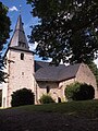
Church in Reelkirchen

Entrance to the moated castle Reelkirchen

Kirchgarten
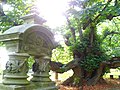
1000 year old linden tree


Web links
- Reelkirchen village
- "Historic tombstones at the church in Reelkirchen"
- Reelkirchen in the Westphalia Culture Atlas
Individual evidence
- ^ Name from the questionnaires from the archive of the Westphalian dictionary
- ↑ Sabine Schieholz: Dictionary High German-Lippish Low German / edited by Sabine Schierholz based on the model by Fritz Platenau. Edited by the Lippischen Heimatbund. - Detmold: Lippischer Heimatbund, 2003 ISBN 3-926311-90-8
- ^ Christian Kuhnke: Lippe Lexikon . Boken Verlag, Detmold 2000. Keyword: Reelkirchen, ISBN 3-935454-00-7 .
- ↑ Birgit Meineke: The place names of the Lippe district . Publishing house for regional history, Bielefeld 2010, ISBN 978-3-89534-842-6 .
- ↑ a b c d reelkirchen.net: History of Reelkirchen, accessed on February 26, 2016
- ↑ Martin Bünermann: The communities of the first reorganization program in North Rhine-Westphalia . Deutscher Gemeindeverlag, Cologne 1970, p. 104 .
- ↑ "Kirchlinde in Reelkirchen" in Monumental Trees at monumentaltrees.com
- ↑ "Kirchlinde in Reelkirchen" in the tree register at www.baumkunde.de
- ↑ and kindergarten school and kindergarten

Altendonop | Blomberg | Borkhausen | Brüntrup | Cappel | Dalborn | Donop | Broken ash | Grossenmarpe | Herrentrup | Höntrup | Istrup | Kleinenmarpe | Maspe | Mossenberg-Wöhren | Reelkirchen | Siebenhöfen | Tintrup | Wellentrup