
Reichenbach (Liederbach)
|
Reichenbach Unterlauf: Woogbach |
||
 The Reichenbach shortly before the confluence with the Rombach to the Liederbach |
||
| Data | ||
| Water code | EN : 2492 | |
| location |
Taunus
|
|
| River system | Rhine | |
| Drain over | Liederbach → Main → Rhine → North Sea | |
| source | in the Taunus , north of Königstein 50 ° 12 ′ 57 ″ N , 8 ° 27 ′ 16 ″ E |
|
| Source height | approx. 658 m above sea level NN | |
| confluence | near Königstein with the Rombach to the Liederbach Coordinates: 50 ° 10 ′ 57 ″ N , 8 ° 27 ′ 17 ″ E 50 ° 10 ′ 57 ″ N , 8 ° 27 ′ 17 ″ E |
|
| Mouth height | approx. 320 m above sea level NN | |
| Height difference | approx. 338 m | |
| Bottom slope | approx. 69 ‰ | |
| length | 4.9 km | |
| Catchment area | 8.213 km² | |
| Discharge A Eo : 8.213 km² at the mouth |
MQ Mq |
99.8 l / s 12.2 l / (s km²) |
The Reichenbach is the almost 5 km long left source brook of the Liederbach . It is richer in water than the right source brook Rombach and thus the main hydrological strand in the brook system. For this reason, some see it as a sub-area (or side name) of the Liederbach. In the city of Königstein it is also called Woogbach .
Surname
- The part of the name 'Reichen' ( richen ) comes from mhd. Riche , rieh , which means rich, strong, full-sounding .
- 'Woog' mhd. Wäc , weigh means: moving water, current, wave, lake, pond .
geography
course
Reichenbach
The headwaters of the Reichenbach are located in the Taunus im Neuwald , a forest area north of Königstein and south of the Kleiner Feldberg . The stream is fed from three sources that are located in a drinking water protection zone. The brook initially flows in a southerly direction. After crossing under the Tillmannweg , which curves to the east, the Reichenbach runs parallel to the Tillmannweg hiking trails on its right and Reichenbachweg on the left. Between the right Fuchstein (height 650 m) and the left Franz head (height 602 m) flowing, the Reichenbach reached the reserve Reichenbachtal . To the southwest of the small Lips temple , the stream is reinforced by the Treisbornbach coming from the left . Then the stream flows right past the Speckkopf (height 526 m) and reaches the urban area of Königstein . At the boundary between Königstein and Falkenstein (a district of Königstein), the so-called New Mühlbach branches off, which served to supply the former Lower and Upper Mills (near today's Mühlweg). It is an artificially created derivative of the Reichenbach.

A little further south is a second, also man-made derivative of the Reichenbach, the Höhenbach , which supplied the city of Königstein with fresh water for many centuries. The Brackenbrook , the original source in the south of the bacon head lying bacon meadow , above Koenigstein on the B8 has flows in the core city area of Koenigstein one from the right in the Reichenbach. A little south of it, the Höhenbach flows back into the Reichenbach. From there the Reichenbach is referred to as the Woogbach .
Woogbach
After crossing under Theresen-Strasse , the Woogbach turns west and passes the Ursuline monastery . To the north of the Freiheitsfelsen it flows through two small ponds in a park , now running in a south-westerly direction, and then merges with the Rombach to the Liederbach coming from the north-west .
Tributaries
- Treisbornbach ( left ), 1.1 km
- Farnbach ( right ), 1.3 km
nature and environment
Creature

The Reichenbachtal is a species-rich biotope with meadows - ( wet meadows , tall herbaceous meadows , lean hay meadows ) and wooded areas ( beech , ash and maple ). On the banks of the Reichenbach there are old alder stocks . In Reichenbachtal come u. a. the following protected animal and plant species:

fauna
- Insects ( great butterfly , red-brown ox-eye ) and Pterostichus cristatus ( ground beetle )
- Fish ( brown trout )
- Amphibians and reptiles ( crested newt , frog , grass snake and smooth snake )
- Birds ( red-backed shrike , middle spotted woodpecker , gray woodpecker and green woodpecker )
flora
- Arnica , spotted orchid , broad-leaved orchid , stately orchid , white forest hyacinth , greenish forest hyacinth and yew
Reichenbachtal nature reserve
The nature reserve with a size of 21.4 hectares was placed under protection in 1966. Of this, 14.0 hectares are in the Falkenstein district and 7.4 hectares in the Königstein district.
Individual evidence
- ↑ Topographic map 1: 25,000 and Google Earth
- ↑ Topographic map 1: 25,000
- ↑ a b Water map service of the Hessian Ministry for the Environment, Climate Protection, Agriculture and Consumer Protection ( information )
- ↑ Modeled runoff values according to the water map service of the Hessian Ministry for the Environment, Climate Protection, Agriculture and Consumer Protection ( notes )
- ^ Marieluise Petran-Belschner: The names of the waters of the Main-Taunus area . In: Rad und rafter. Issue 18, 1990.
- ↑ Natura 2000, Reichenbachtal. Hessian Ministry for the Environment, Rural Areas and Consumer Protection, archived from the original on September 1, 2007 ; Retrieved April 18, 2008 .
- ↑ Fish-ecological study of the Rhine and Main tributaries in the area of the southern roofing of the Taunus with special consideration of the fish species in Appendix II of the Habitats Directive ( Memento of the original from March 5, 2016 in the Internet Archive ) Info: The archive link was automatically inserted and not yet checked . Please check the original and archive link according to the instructions and then remove this notice. , Hessen-Forst, species report 2004
- ↑ Ordinance on the “Reichenbachtal” nature reserve in the Obertaunus district of February 17, 1966 . In: Higher nature conservation authority (ed.): State gazette for the state of Hesse. 1966 No. 12 , p. 399 , point 266 ( online at the information system of the Hessian state parliament [PDF; 4.1 MB ]).
- ↑ Hermin Herr: Lexikon vom Hohen Taunus, 1993, ISBN 3-7829-0437-0 , p. 92
Web links
- Reichenbachtal ( Memento from February 7, 2012 in the Internet Archive ) from denkmal-koenigstein.de
- Woogtal ( Memento from June 6, 2012 in the Internet Archive ) from denkmal-koenigstein.de
- Hydraulic engineering ( Memento from June 6, 2012 in the Internet Archive ) from denkmal-koenigstein.de
- Reichenbachtal ( Memento from September 1, 2007 in the Internet Archive ) Natura 2000 Hessen
- Falkenstein im Taunus: In the "Reichenbachtal" there used to be even 'whey cures'
- Environmental report with integrated species protection contribution to development plan S 13 "Sportplatz Schneidhain" , (PDF, 7.9 MB)
Picture gallery

The Reichenbach in the Woogtal (near Königstein / Ts)

The Woogtal in 1900

The Reichenbach (also called Woogbach here)

The Reichenbach near Königstein / Ts

Pond in the Woog Valley
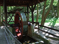
Mill wheel on Reichenbach


Old King |
Burghain Falkenstein |
Upper Emsbach Valley |
Reichenbachtal |
Rentmauer Dattenberg |
Riedelbacher Heide |
Schmittröder meadows |
Reifenberger meadows |
Anspach pond |
Hünerbergwiesen von Oberursel |
Hinterste Neuwiese near Kronberg |
Waldwiesenbachtal from Oberhöchstadt |
Dombach meadows from Riedelbach |
Detzelbachtal near Wernborn |
Saubach and Niedgesbach near Schmitten |
Kirdorfer Feld near Bad Homburg |
Silberbachtal near Schloßborn |
Röllbachtal near Usingen |
Dattenbachtal between Kröftel and Vockenhausen
Former NSG:
Stuhlberg |
Marble stone