
Saint-Hilaire-sur-Erre
| Saint-Hilaire-sur-Erre | ||
|---|---|---|
|
||
| region | Normandy | |
| Department | Orne | |
| Arrondissement | Mortagne-au-Perche | |
| Canton | Cetone | |
| Community association | Communauté de communes des Collines du Perche Normand | |
| Coordinates | 48 ° 19 ′ N , 0 ° 44 ′ E | |
| height | 96-188 m | |
| surface | 15.12 km 2 | |
| Residents | 529 (January 1, 2017) | |
| Population density | 35 inhabitants / km 2 | |
| Post Code | 61340 | |
| INSEE code | 61405 | |

Saint-Hilaire-sur-Erre is a French municipality with 529 inhabitants (as of January 1 2017) in the department of Orne in the region of Normandy . It belongs to the arrondissement of Mortagne-au-Perche and the canton of Ceton .
geography
The name addition is derived from the Erre, a tributary of the Huisne . Neighboring municipalities are Perche en Nocé in the northwest, Berd'huis in the northeast, Nogent-le-Rotrou in the east and Val-au-Perche in the south and west.
Population development
| year | 1962 | 1968 | 1975 | 1982 | 1990 | 1999 | 2008 | 2015 |
|---|---|---|---|---|---|---|---|---|
| Residents | 416 | 377 | 399 | 421 | 460 | 520 | 596 | 533 |
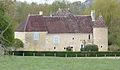
Castle of Saint-Hilaire-sur-Erre

Mairie Saint-Hilaire-sur-Erre


Web links
Commons : Saint-Hilaire-sur-Erre - Collection of images, videos and audio files