Irai
| Irai | ||
|---|---|---|
|
|
||
| region | Normandy | |
| Department | Orne | |
| Arrondissement | Mortagne-au-Perche | |
| Canton | Tourouvre | |
| Community association | Pays de L'Aigle | |
| Coordinates | 48 ° 40 ′ N , 0 ° 42 ′ E | |
| height | 203-273 m | |
| surface | 14.85 km 2 | |
| Residents | 613 (January 1, 2017) | |
| Population density | 41 inhabitants / km 2 | |
| Post Code | 61190 | |
| INSEE code | 61208 | |
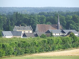
 Look at Irai |
||
Irai is a French municipality with 613 inhabitants (as of January 1 2017) in the department of Orne in the region of Normandy . Administratively it belongs to the arrondissement of Mortagne-au-Perche and is part of the canton of Tourouvre (until 2015 part of the canton of L'Aigle-Est ). The inhabitants are called Idriuciens .
geography
Irai lies on the Avre River , which forms the southern and southeastern municipal boundaries. Irai is surrounded by the neighboring municipalities of Crulai in the north and northwest, Vitrai-sous-Laigle in the northeast, Beaulieu in the south and east, Tourouvre au Perche with Randonnai in the south and Les Aspres in the west and southwest.
Population development
| 1962 | 1968 | 1975 | 1982 | 1990 | 1999 | 2006 | 2013 |
|---|---|---|---|---|---|---|---|
| 503 | 402 | 328 | 408 | 427 | 458 | 525 | 590 |
| Source: Cassini and INSEE | |||||||
Attractions
- Saint-Pierre church from the 15th century
- 17th century castle
Web links
Commons : Irai - collection of images, videos and audio files
