Saint-Servais (Finistère)
|
Saint-Servais Sant-Servez-Landivizio |
||
|---|---|---|
|
|
||
| region | Brittany | |
| Department | Finistère | |
| Arrondissement | Morlaix | |
| Canton | Landivisiau | |
| Community association | Pays de Landivisiau | |
| Coordinates | 48 ° 31 ′ N , 4 ° 9 ′ W | |
| height | 23-116 m | |
| surface | 10.29 km 2 | |
| Residents | 782 (January 1, 2017) | |
| Population density | 76 inhabitants / km 2 | |
| Post Code | 29400 | |
| INSEE code | 29264 | |
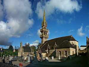
 Saint Servais church |
||
Saint-Servais ( Breton Sant-Servez-Landivizio ) is a French municipality with 782 inhabitants (at January 1, 2017) in the department of Finistère in the region Bretagne . It belongs to the community association Communauté de communes du Pays de Landivisiau .
location
The municipality is located in northwest Brittany 18 kilometers south of the Atlantic coast .
Morlaix is 25 kilometers east, the city and port of Brest 28 kilometers southwest and Paris about 480 kilometers east (as the crow flies ).
traffic
At Landivisiau and Landerneau there are departures on the expressway E 50 Brest- Rennes and regional train stations on the mostly parallel railway line.
The Brest train station is the terminus of the TGV Atlantique to Paris and the Aéroport de Brest Bretagne airport near Brest is the nearest regional airport . The Landivisiau military airfield is partly on the territory of the municipality.
Population development
| year | 1962 | 1968 | 1975 | 1982 | 1990 | 1999 | 2006 | 2017 |
| Residents | 501 | 470 | 426 | 568 | 505 | 553 | 637 | 782 |
| Sources: Cassini and INSEE | ||||||||
Attractions
See: List of Monuments historiques in Saint-Servais (Finistère)
literature
- Le Patrimoine des Communes du Finistère. Flohic Editions, Volume 1, Paris 1998, ISBN 2-84234-039-6 , pp. 664-667.
