
Sankt Johann am Tauern
| Sankt Johann am Tauern ( village ) | |||
|---|---|---|---|
|
|||
| Basic data | |||
| Pole. District , state | Murtal (MT), Styria | ||
| Judicial district | Judenburg | ||
| Pole. local community | Pölstal ( KG St. Johann Sonnseite , St. Johann Schattseite ) | ||
| Locality | Sankt Johann am Tauern sunny side , Sankt Johann am Tauern shady side | ||
| District | Sankt Johann am Tauern | ||
| Coordinates | 47 ° 21 '25 " N , 14 ° 28' 9" E | ||
| height | 1056 m above sea level A. | ||
| Building status | 70 (addresses 2019, approx. ) | ||
| Post Code | 8765 St. Johann am Tauern | ||
| Statistical identification | |||
| Counting district / district | Sankt Johann am Tauern (62044 002) | ||

|
|||
| Source: STAT : index of places ; BEV : GEONAM ; GIS-Stmk | |||

Sankt Johann am Tauern is a place in the Upper Murtal in Styria as well as a part of the municipality of Pölstal in the Murtal district . It was an independent community until 2014 .
geography
|
Sankt Johann am Tauern district , counting district |
|
|---|---|
| Basic data | |
| Pole. District , state | Murtal (MT), Styria |
| Judicial district | Judenburg |
| Pole. local community | Pölstal |
| Coordinates | 47 ° 21 ' N , 14 ° 28' E |
| Residents of the stat. An H. | 441 (January 1, 2020) |
| Building status | 252 (addresses 2019 ) |
| surface | 84.8 km² |
| Post Code | 8765 St. Johann am Tauern |
| Statistical identification | |
| Counting district / district | Sankt Johann am Tauern (62044 002) |
| Location in the Murtal district | |

|
|
| Addresses sunny side , shady side (also Ortsch. And KG); former municipality of Sankt Johann [ am Tauern ] 1850–2014, GKz. 60819, ZSpr. 000 Source: STAT : Directory of places ; BEV : GEONAM ; GIS-Stmk |
|
The location is around 25 kilometers northwest of Judenburg . It includes the rear Pölstal of over 4 kilometers north of Möderbrugg about a good 10 km to the Schulterer height across to Hohe Tauern and the Pölsen , Quelltal of Pöls on the 970- 1,260 m above sea level. A. Height.
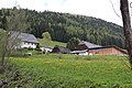
The village is about 10 kilometers north of the center of the Pölstal . It is located in the back valley at around 1055 m above sea level. A. Height. The place comprises about 70 houses, mostly on the left on Pölsbach (sunny side), some houses on the right (shady side).
The area of Sankt Johann am Tauern comprises the two parts of the sunny side on the left (east side) in the valley and the shady side on the right (west side), with numerous scattered locations and some weekend house settlements , together around 250 houses with a good 400 inhabitants.
The frame is formed by the ridge of the Grießstein ( 2337 m above sea level ) and the south ridge ( Kesseleck 2308 m above sea level ) of the Seckauer Tauern in the west, the ridge of the Bruderkogel ( 2299 m above sea level ) of the Wölzer Tauern in the east , and the main ridge of the Niedere Tauern with the Bösenstein ( 2448 m above sea level ) in the north-west.
Triebener Straße (B114) runs through the village .
| Rottenmann (Gem., District Liezen ) |
Hohentauern (Gem.)
|
|
| Bretstein (district) ∗ |
.svg)
|
|
|
Zechnersiedlung ∗∗ Möderbrugg Sankt Oswald |
Gaal (mixed) ∗ |
history
Here the mule track ran over the Triebener Tauern , which was already important in pre-Roman times and was then part of the Roman road Virunum - Ovilava (Zollfeld - Wels). Whether the post station (Mansio) Tartursanis was here or in Hohentauern is unknown due to a lack of archaeological evidence.
It seems possible, however, that a Stadelhof or Zehenthof was founded here in the earliest times of the Baiwar conquest . The Johanneskirche was built around the year 1300, it is mentioned for the first time in 1363. The place was formed as a Kirchweiler , it is probably 1490 as s. Johans was first mentioned in an Admonter land register.
The road was expanded again from the early modern era.
In 1784 (1794) the evangelical community got a tolerance prayer house , today's church of faith . The place was a locality of the Catholic parish of St. Oswald until 1788 , in 1892 it also became a parish.
Sankt Johann community
The political community St. Johann am Tauern was established in 1849/50 from the two tax communities, then cadastral communities St. Johann Schattseite and St. Johann Sonnseite . It belonged to the district of Bruck until 1868 , then to the district of Judenburg , and until 1976 to the judicial district of Oberzeiring , then to the judicial district of Judenburg , most recently to the new district of Murtal from 2012.
As part of the Styrian municipal structural reform , it was merged with the municipalities of Bretstein , Oberzeiring and Sankt Oswald-Möderbrugg on January 1, 2015 . The new community is called Marktgemeinde Pölstal . The old community continues to be run as a counting district .
- Community representation
Until the dissolution of the municipal council on December 31, 2014, due to the municipal council election 2010, it was composed as follows:
The last mayor was Sonja Hubmann (ÖVP) until December 31, 2014.
coat of arms
 |
Blazon : "In Red on pending diagonally right gold, with a gold banner entwined cross bar and left top right bottom of each one abutting the plate edges flamed golden bells flower accompanied ."
Awarded: February 29, 1988 (effective April 1, 1988), LGBl. 1988, 4th issue, No. 14; |
| Justification for the coat of arms: The cross rod (ferula) with the banner is the saint attribute of the parish patron and name patron St. John the Baptist , the flowers adorn the church consecrated to him . |
Population development

Source: Statistics Austria
Economy and Infrastructure
According to the 2001 census of workplaces , there were 20 workplaces with 58 employees in the municipality as well as 128 out-commuters and 20 in-commuters. There were 54 agricultural and forestry holdings (33 of which were the main occupation), which together farmed 3356 hectares (as of 1999).
- education
There is a kindergarten and an elementary school.
Culture and sights
in the town:
- Parish Church of St. Johann
- Vicarage , next to the church
- Calvary Chapel
in the area:
- Church of the Faith , Protestant
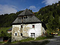
- Front short , homestead with an old mill
- Oberer Lerchbacher , homestead
- Schellhube , homestead
- Pölsenhube (Maximilianhube), former hunting domicile of Emperor Maximilian I, in Pölsen

Catholic parish church

Rectory

Evangelical Church of Faith

Kalvarienbergkapelle near Vorderen Kurz

Mill at the front short

Schellhube
Upper Lerchbacher
Schaffer

Pölsenhube


.jpg)

.jpg)

Personalities
Sons and daughters of St. Johann am Tauern:
- Fred Rößner (1911–2005), athlete, trainer and sports pioneer
- Hermann Kröll (1939–2016), politician (ÖVP), mayor of Schladming 1975–2005
Web links
Individual evidence
- ↑ In gazetteer 2001 as a hamlet classified.
- ↑ Ulla Steinklauber: Roman times (and late antiquity) - from the turn of the ages to the 5th century. In: Bernhard Hebert (Ed.): Prehistory and Roman times in Styria. Volume 1 of the history of Styria. Ed. on behalf of the Historical Commission for Styria, 2nd edition, Böhlau Verlag, Vienna / Cologne / Weimar 2018, ISBN 978-3-205-23253-7 , p. 709 f (full article 701-807; limited preview in Google Book search).
- ↑ a b c Heinrich Purkarthofer: The Styrian municipal coat of arms awarded in 1988. Appendix in: Mitteilungen des Steiermärkisches Landesarchivs 39, St. Johann am Tauern , p. 37 ( full article p. 29–40, pdf , landesarchiv.steiermark.at; there p. 9).
- ↑ a b c Parish St. Johann am Tauern. Diocese of Graz-Seckau: catholic-kirche-steiermark.at.
-
↑ Decree of the governor of September 20, 1850, with which the new local parishes established according to the provisional law of March 17, 1849 with their allocation to the political judicial and tax office districts in the Crown Land of Styria are made known. General state law and government gazette for the Crown Land of Styria. 1850, XXI. Piece, No. 378.
General State Law and Government Gazette for the Crown Land of Styria. 1850 (Bruck district supplement) . - ^ Styrian municipal structural reform .
- ↑ Section 3, Paragraph 8, Item 2 of the Act of December 17, 2013 on the reorganization of the municipalities of the State of Styria ( Styrian Municipal Reform Act - StGsrG). Provincial Law Gazette for Styria of April 2, 2014. No. 31, year 2014. ZDB -ID 705127-x . P. 3.
- ↑ A look at the community of Sankt Johann am Tauern

Districts (municipality structure) : Bretstein | Möderbrugg | Oberzeiring | St. Johann am Tauern | St. Oswald
Cadastral municipalities: Bretstein | Möderbrugg | Oberzeiring | St. Johann shady side | St. Johann Sonnseite | St. Oswald
Locations: Bretstein | Gföllgraben | Möderbrugg | Oberzeiring | Sankt Johann am Tauern shady side | Sankt Johann am Tauern sunny side | Saint Oswald | Zeiringgraben | Train valley
Villages: Bretstein-Gassen • Oberzeiring • Sankt Johann am Tauern • Sankt Oswald • Zistl | Hamlet: Tenegg | Rotten: Bretstein • Möderbrugg • Propstei • Schwarzviertel • Tratten • Unterzeiring • Zistl | Settlements: Habererhube • Kaltenegger settlement • Unterhauser • Weingruber settlement • Wieser settlement • Zechner settlement | Scattered houses: Authal • Bretstein front of the church • Bretsteingraben • Drohschlag • Folding • Gföllgraben • Gosch digging • Karleiten • Deep digging • Koingraben • Lentschachgraben • Lerch digging • Moarhof • Möderbach • Nestelgraben • Palsgraben • Pölsen • Riedl digging • Schattseite • Schneeberg • Black quarter • Sonnseite • Wenischgraben • Zeiringgraben • Zugal | Other locations: Old silver mine • Franzlbauerhütte • Hanfelden (castle) • Rear Kurz • Klosterneuburger Hütte • Koiner • Upper Lerchbacher • Pölsenhube • Probstei (castle) • Schaffer • Schell • Vordere Kurz • Weingruber
Counting area: Bretstein | Oberzeiring | St.Johann am Tauern | St. Oswald-Möderbrugg
Former parishes: Bret [t] stein 1850–2014 | Oberzeiring 1850–2014 | Sankt Johann [am Tauern] 1850–2014 | [Sankt] Oswald [-Möderbrugg] 1850–1951 / 2014