Starigrad Paklenica
| Starigrad | ||
|
||
|
|
||
| Basic data | ||
|---|---|---|
| State : |
|
|
| County : |
|
|
| Height : | 0 m. i. J. | |
| Residents : | 1,876 (2011) | |
| Telephone code : | (+385) 023 | |
| Postal code : | 23 244 | |
| License plate : | ZD | |
| Boat registration : | SD | |
| Structure and administration (status: 2013, cf. ) |
||
| Community type : | local community | |
| Mayor : | Krste Ramić ( HDZ ) | |
| Website : | ||

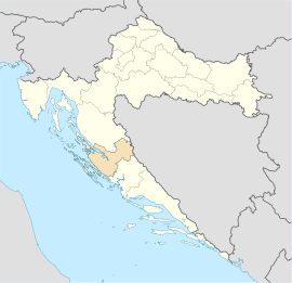
Starigrad (literally Old City ), also called Starigrad-Paklenica , Italian Cittavecchia , is a coastal town in Croatia , in the Zadar County .
Location and inhabitants
The Starigrad-Paklenica municipality consists of the three places Seline, Tribanj and Starigrad and has 1,876 inhabitants, 1,140 of whom live in Starigrad (2011 census). It is located between Karlobag and Zadar at the foot of the Velebit Mountains with the Paklenica National Park, not far from the A1 motorway . Starigrad is not to be confused with Stari Grad on the island of Hvar .
history
The first traces of settlement in Velebit come from the Mesolithic . It is assumed that the sea level was around 120 m lower then than it is today. The entire northern Adriatic was mainland. The steadily rising water level after the Ice Age drove the inhabitants slowly from the sinking favorable locations into the more inhospitable mountains. In the Bronze Age , numerous defenses were built on rocky peaks. These systems, called gradines, over Starigrad, Morič, Seline or Milovac were used to protect the most productive fields. At the same time, they formed the intersection of shepherds' and trade routes and were observation stations for the important shipping traffic. In the vicinity of the Gradine there are often graves of local rulers, as can be seen on the northern edge of Starigrad, in Matkovača. With the establishment of the Roman province of Dalmatia at the beginning of the 1st century, a Roman settlement also emerged in Starigrad. Argyruntum was on a 3.4 hectare large, now silted island, the area east of the port. Emperor Tiberius had protective walls and towers built. Finds from four hundred graves testify to the great wealth and lively trade relations in the Mediterranean area. The collapse of the Roman Empire ended the long period of peace ( Pax Romana ) in the 4th century . The city was the victim of various lootings. In the course of the Great Migration , the Croats came to Dalmatia. The oldest relic near Starigrad is the church of St. George in Rovanjska from the 9th or 10th century. Medieval traces are the St. Peter's Church (13th century) and the castles "Večka kula" on a promontory east of Starigrad and the "Paklarić" on the prehistoric ruins above the entrance to Velika Paklenica. In 1527 the Turks took the hinterland of Dalmatia. With the conquest of the Novigrad Sea , the Turks were able to control the land connection between northern and southern Croatia. The coastal slopes of Velebit were constantly the scene of armed conflicts and looting. After 150 years of desertification, the Venetian rulers began to recolonize the abandoned land from 1671. By the end of the 17th century, the Velebit foothills were again populated with Bunjevici, Croats from the neighboring regions. After the Napoleonic Wars, Dalmatia came under Austrian rule in 1815 and belonged to the Austro-Hungarian monarchy until 1918 .
In the hinterland of Starigrad, the sparsely populated karst area of Velebit, which slopes down to the sea, there was a burial ritual until the 1950s, the traces of which can still be found today. The dead from the remote courtyards were laid down in certain places on their last way and "greeted" the sun one last time. These resting places of the dead, called Mirilo , consist of horizontally aligned limestone slabs with an erect, hardly elaborately worked head and a simple foot stone and were adapted to the body size. Characteristic is the arrangement of the Mirilo of a family in increasing size. In the commemoration of the dead, the places called Mirila, lying directly in the landscape without any fencing, were more important than the actual grave. From the center of Starigrad, a one and a half hour circular route leads to two Mirila. Others can be found at the hamlet of Ljubotić above the village of Tribanj Kruščica, a place between Karlobag and Starigrad on the Adriatic highway .
present
Until the advent of tourism, Starigrad was characterized by fishing and cattle breeding. As the main town of the Paklenica National Park, which has existed since the 1940s, Starigrad has been spared construction sins to some extent. In Tito's time, the village was on the edge of a restricted military area, as a huge bunker for the state and military leadership was built in the Velika Paklenica Canon. This turned out to be too damp in the end and was never set up. Today it is partly used for exhibitions and can be viewed as a "bunkeri".
Starigrad is now a vacation spot. The close proximity of the low mountain range and the sea offers relaxation seekers, athletes and nature lovers an unusually broad field of activity. The up to 1,700 meter high cliffs are considered to be one of the most beautiful climbing areas in Europe. In the area around Starigrad there are several locations for Karl May films such as Winnetou .
Web links
- Web link of the municipality in Croatian


