
Stockhausen (Herbstein)
|
Stockhausen
City of Herbstein
Coordinates: 50 ° 33 ′ 48 ″ N , 9 ° 26 ′ 47 ″ E
|
|
|---|---|
| Height : | 302 m above sea level NHN |
| Area : | 17.72 km² |
| Residents : | 811 (December 31, 2016) |
| Population density : | 46 inhabitants / km² |
| Incorporation : | August 1, 1972 |
| Postal code : | 36358 |
| Area code : | 06647 |
_Luftaufnahme.jpg) Aerial view of the village (summer 2018) from the direction of Blankenau (southeast)
|
|
Stockhausen is a district of Herbstein in the Vogelsbergkreis in central Hesse . The oldest village kindergarten is located here, which was set up in the former Grand Duchy of Hesse-Darmstadt .
Geographical location

The village of Stockhausen is located on the north-east edge of the Vogelsberg and stretches along the course of the Altefeld in a wide valley that opens out into the meadow landscape towards the east . The place is at an average altitude of 300 to 350 meters and is bordered by a soft to very hilly meadow landscape. Stockhausen is the largest district in the city of Herbstein. Stockhausen can be reached via the L 3139 state road, which runs from Hosenfeld-Blankenau / Großenlüder-Müs ( Fulda district ) through the village in the direction of Schadges . The town is connected to the regional transport network via the L 3139 and the district roads K 87 and K 88. Schadges can be reached in 2 km (in the west), Hosenfeld-Blankenau in 2 km (in the south-east), Großenlüder-Müs (in the east) and Rudlos (in the north-east) in 6 km each. Lauterbach is 11 km away, Fulda 22 km and Herbstein 9 km away.
history
prehistory
When the settlement was built is unknown, but the barrows , which can be found in large numbers around and in the district , testify to millennia-old human culture . Several were opened to reveal two lance tips, a dagger blade, two spiral needles, a needle, a diadem and a key.
middle Ages
There are different assumptions about the origin of the name; most likely it can be derived from the oldest form of the name, Stockhusen . The first houses were built on high posts, i.e. on sticks, to protect against flooding in the swampy valley.
The oldest mention of Stockhausen comes from 1287. It is named under the name Stochusen when goods and income were donated in Stockhausen to found the Blankenau monastery .
Old is the seat of a high or blood court here . In 1428 the Stockhausen court was taken over by the Barons von Riedesel .
Modern times
In 1603 the free school was founded and in 1841 the first kindergarten in the then Grand Duchy of Hesse . In 1846 the construction of the new church began as a replacement for an older church.
In 1874 the volunteer fire brigade Stockhausen was founded, in 1880 the savings and loan fund Stockhausen and in 1894 the Germania choir as a men's choir. In 1899 a major fire in the north-eastern part of Stockhausen destroyed 22 residential buildings and 33 outbuildings. The Stockhausen Fruit and Horticultural Association was founded in 1899, the Germania mixed choir in 1900 and the Stockhausen Sports Association in 1920. 1946 was the re-establishment of the Stockhausen sports club.
Territorial reform
On August 1, 1972, as part of the regional reform in Hesse, it was incorporated into the city of Herbstein by state law .
Territorial history and administration
The following list gives an overview of the territories in which Stockhausen was located and the administrative units to which it was subordinate:
- before 1803: Holy Roman Empire , Stockhausen court of the barons of Riedesel zu Eisenbach (man fief of the Prince Diocese of Fulda )
- from 1806: Grand Duchy of Hesse , Stockhausen Court
- from 1815: German Confederation , Grand Duchy of Hesse, Province of Upper Hesse , Altenschlirf Office
- from 1821: German Confederation, Grand Duchy of Hesse, Province of Upper Hesse, District District Herbstein (separation between justice ( District Court Altenschlirf ) and administration)
- from 1825: German Confederation, Grand Duchy of Hesse, Province of Upper Hesse, Lauterbach District District
- from 1848: German Confederation, Grand Duchy of Hesse, Alsfeld administrative region
- from 1852: German Confederation, Grand Duchy of Hesse, Province of Upper Hesse, Lauterbach district
- from 1866: North German Confederation , Grand Duchy of Hesse, Province of Upper Hesse, Lauterbach district
- from 1871: German Empire , Grand Duchy of Hesse, Province of Upper Hesse, Lauterbach district
- from 1918: German Empire, People's State of Hesse , Province of Upper Hesse, Lauterbach district
- from 1945: American occupation zone , Greater Hesse , Darmstadt administrative district, Lauterbach district
- from 1949: Federal Republic of Germany , State of Hesse , Darmstadt district, Lauterbach district
- on August 31, 1972 Stockhausen was incorporated as a district of the newly formed municipality of Herbstein.
- from 1972: Federal Republic of Germany, State of Hesse, Darmstadt administrative district, Vogelsberg district
- from 1981: Federal Republic of Germany, State of Hesse, Gießen district , Vogelsberg district
Law
Substantive law
In Stockhausen, the Riedesel'schen ordinances were considered particular law . The Common Law applied only to the extent those regulations did not contain provisions. Theoretically, this special right retained its validity even while it belonged to the Grand Duchy of Hesse in the 19th century, but only individual provisions were used in judicial practice. The particular law was replaced on January 1, 1900 by the civil code that was uniformly valid throughout the German Empire .
Court constitution since 1803
In the Landgraviate of Hesse-Darmstadt , the judicial system was reorganized in an executive order of December 9, 1803. The “Hofgericht Gießen” was set up as a court of second instance for the province of Upper Hesse . The jurisdiction of the first instance was carried out by the offices or registry lords and so from 1806 the " Riedeselsche Patrimonialgericht Altenschlirf" was responsible for Stockhausen . The court court was the second instance court for normal civil disputes, and the first instance for civil family law cases and criminal cases. The superior court of appeal in Darmstadt was superordinate .
With the establishment of the Grand Duchy of Hesse in 1806, this function was retained, while the tasks of the first instance were transferred to the newly created regional courts in 1821 as part of the separation of jurisdiction and administration. "Landgericht Altenschlirf" was therefore from 1821 to 1853 the name of the court of first instance in Altenschlierf, which was also responsible for Stockhausen. In 1853 the regional court was moved to Herbstein.
On the occasion of the introduction of the Courts Constitution Act with effect from October 1, 1879, as a result of which the previous grand ducal Hessian regional courts were replaced by local courts in the same place, while the newly created regional courts now functioned as higher courts, the name was changed to the Herbstein Local Court and assigned to the district of the regional court Pouring . From 1943, the Herbstein District Court was only operated as a branch of the Lauterbach District Court before it was finally dissolved in 1968 and added to the Lauterbach District Court area. In the Federal Republic of Germany, the superordinate instances are the Marburg Regional Court , the Frankfurt am Main Higher Regional Court and the Federal Court of Justice as the last instance.
Population development
Occupied population figures up to 1970 are:
- 1961: 749 Protestant and 125 Catholic residents
| Stockhausen: Population from 1834 to 1967 | ||||
|---|---|---|---|---|
| year | Residents | |||
| 1834 | 836 | |||
| 1840 | 892 | |||
| 1846 | 935 | |||
| 1852 | 886 | |||
| 1858 | 867 | |||
| 1864 | 891 | |||
| 1871 | 888 | |||
| 1875 | 883 | |||
| 1885 | 912 | |||
| 1895 | 871 | |||
| 1905 | 834 | |||
| 1910 | 848 | |||
| 1925 | 776 | |||
| 1939 | 715 | |||
| 1946 | 1,037 | |||
| 1950 | 986 | |||
| 1956 | 883 | |||
| 1961 | 875 | |||
| 1967 | 859 | |||
| Data source: Historical municipality register for Hesse: The population of the municipalities from 1834 to 1967. Wiesbaden: Hessisches Statistisches Landesamt, 1968. Other sources: | ||||
Desertification in the Stockhausen Grund
prehistory
- The Stockhausen, Schlechtenwege and Schadges districts still partly belong to the eastern foreland of the Vogelsberg , half of which is formed by the red sandstone soils in front. Some of the best soils have been identified in the Stockhausen valley. A relatively long vegetation period also distinguishes this area from the actual Vogelsberg. While there are no fruit trees there, they can be found in abundance here in the sheltered location. The prehistoric finds also show that this area was settled in prehistoric times. Stockhausen is by far the most conveniently located place. It was already the largest in the Middle Ages and was therefore in the area of interest of both the monastery in Blankenau and the Junker in Eisenbach. Both parties had property there, as in Schadges, and when the Fuldisch-Riedesel feud, also known as the Stein feud , broke out in 1465 , both places were declared neutral for this reason. But the battle raged over the rest of the country. From the later complaints we can see that most of the locations of the Stockhausen Court were destroyed. The Blankenau monastery owned eight villages and deserted areas in the Stockhausen court: Niederndorf, Bedelsdorf, Gensdorf, Stockhausen, Schadges , Rixdorf ( Rixfeld ), Reichlos and Rippach. The desert was still uninhabited in 1534, since this feud. The provost of Blankenau complained this year about the Riedesel, because these places had to do apprenticeship and compulsory service to the monastery, especially the forest smiths in Schadges and Stockhausen twelve flocks (plowshares) annually. The Riedesel would have taken that from the monastery and put cow and wine transport money on the goods. They had ordered the people who owned the desertification according to desert law to build in Stockhausen instead of the right houses. The Dankrode desert had belonged to the monastery and it had loaned it to the people of Hainzell . However, after the peasant uprising, the Riedesel defeated a vicar at Blankenau, Michael Pfannschmidt, took him prisoner, brought him to Eisenbach and there forced the desert to lend its subscribers to Schlechtenwege and Stockhausen. Later they even lent the desert themselves.
- The residents of the Stockhäuser Grund, who had fled to the protected main village due to the war, were forced to stay there and build there . The Riedesel probably needed them to fill abandoned farms in Stockhausen. The Blankenau interest-bearing villages therefore remained deserted. The Riedeselsche Stockhausen, which was already the largest town due to its favorable location, now emerged from the dispute as an even larger town with an expanded area. Since the abandoned places had not been in an unfavorable agricultural position, the fields were nowhere completely devastated.
- The two deserted areas of Dankenrod and Rißbach , located in Schlechtenweg's area, extend into the Stockhausen district with their corridors and are therefore also dealt with here.
Dankenrod
In 1324 Heinrich IV. Abbot of Fulda confirmed the donations made by his predecessors to the Blankenau monastery in Richolffs, Rixfeld, Burkhards, Salzschlirf, Kirchstockhausen, Gersdorf, Dangkerode, Borsa and Eichenau. In 1337 Werner von Blankenwald sold the clergy women in Blankenau a hoof in Dankerode, called Rindesschenkel, and the "Hofstadt uffem Hagen" for 25 pounds Heller.
In 1383 Metze von Lisberg had exchanged two estates at Oberndorff and one at Gundolfs to Else von Merlau for her two estates in Dantzinrode and half a mill in Risbach. Furthermore, half of the Mohlnstatt (mill site) in the village, Dangkenrod and the wood that is located near Dangkenrod and is called "Hart" is mentioned. In 1384 Friedrich Herr zu Lisberg renounced the Gutchen zu Dankerode that his mother bought from Erhard von Herbstein to donate it to the Blankenau altar. In 1405, Rörich von Eisenbach and Anna confirmed to his wife a donation from those von Lisberg, namely an eternal vicarie in Blankenau, to which they gave a farm in Lüder and the goods in Dangkenrode. They increase this foundation through the water, the fishing from the Angewede, since the Bornfloss goes into the water on Schlechtenwege, up to the Lange Wiese, which is called "in der Paltz", located between Dangkenrode and Rissbach. Landau also says "The fish water, called the Nente, between Dankerode and Risbach".
The Stockhausen court's land division of 1524 states: "... over the Hartt to the Altenhege and further up to the path between Schlechtenwege and Dankenrodt and from the path over the water in Weishen Wiesen jn the Borngen and further up the path that then goes from Herbstein to Dankenrodt, from the path to the Heiligenstücke jn the Rispach, the way out when one goes to Schlirf ... ". In the Kopei book Ad. Hermann Riedesel reads "holy Slagborn in the risbach" instead of "holy pieces". In 1531, the Stockhausen court's division of land reads "into the Danckerode near the old schlage". Around 1530, in the legal dispute between the Blankenau monastery and the Riedesel, according to the Fulda files, it was stated that the desert and land belonged to the Blankenau monastery and had been cultivated and taken over from Hainzell and that meadows there had been given to the mayor at Schlechtenwege for interest. In 1556 Dankenrod was named as a desert in the Herbstein court.
In the Altfelltal, not in a valley widening, but in a narrow valley between Stockhausen and Schlechtenwegen, not far from the medieval long-distance road, the Ortweg, the Dankenrod settlement was located. The choice of this place and the man-made hill rising up in a bend in the brook, which is also marked on the measuring table with a height of 351 m, suggest a defensive foundation. The people tell of a castle belonging to the Lords of Dankenrod, which is said to have stood on a hill. It was probably a fortified courtyard, perhaps the "Hofstadt uffm Hagen" named in 1337. In addition to this change in the soil, which is immediately visible to everyone, the trained eye also recognizes the inconspicuous remains of three other buildings on the right bank of the stream: relief disturbances (raised, rectangular slopes), finds of broken glass and clay , and strikingly black earth. In the molehills, the hill also shows clay and pot shards and only poor grass growth. The building, 30 m east of the hill, left behind a particularly large amount of clay and iron slag. These and heavily rusted iron on the banks of the stream are the only evidence of a former iron smelter associated with the place.
The phosphate profile determined here shows a high phosphate content on and on the Küppel, while the rest of the area behaves neutrally, in fact the lowest phosphate content lies within the iron slag rectangle. All of this speaks for the method developed by Lorch. However, the fact that the left, shallow steep bank, which has probably always been outside of human activity, shows increased phosphate content, confirms the conclusion that this is increased where the ground is only shallow (as on and on the Küppel) and is particularly low there, where it is very deep (at the left foot of the cup and in the iron slag rectangle). The fields in the village of Dankenrod have remained fields and meadows. After the town was destroyed, it was first ordered from Hainzell, 3½ km away, because Blankenauer subjects sat here, just as they did in Dankenrod. They had a good access road to these remote fields on the Ortweg. The Riedesel, however, moved the desert into their area and enfeoffed farmers from nearby villages: from Schlechtenwege and Stockhausen. So the conditions were more natural and this is how they have been preserved to this day: The fields of the Dankenrod desert are divided into the Schlechtenwege and Stockhausen districts and are still cultivated from there.
Rissbach
In 1312 Mechthildis, Trabotho's widow von Eisenbach, gave her village Rispach and the Rischberg mountain to the Blankenau monastery with the consent of her sons, daughter and son-in-law. In 1338 Eckehard von Bymbach and Adelheid sold his wife to the Blankenau monastery, their village Risbach for 270 pounds Heller. In 1340, Theodoricus Propst, Elizabeth Abbess in Blankenau and the whole convent of nuns there announced that the knight Friedericus von Hirtzesberg gave his sister Gertrudis, who lives as a nun in the convent, 30 pounds of Heller and 3 pounds of talents annually in the village of Rispach for their private, physical needs bought.
In 1383 Metze von Lisberg exchanged two estates in Oberndorf and one with Gundolfs for Else von Merlaus, both estates in Dankenrod and "eyne half moln stat, which holds czise Fischern zu Rispach" .
From Schlechtenwege down in the Altfelltal, below Dankenrod lies the Balswiese, which was called "in dem Paltz" in 1405 and was located between Dankenrod and Risbach. Risbach was located below Dankenrod on the Prinzenbach, southeast of the Reißberg belonging to this village. Here the corridor at the Schlechtenweger-Stockhäuser border is called "am Forellenteich" and joins the Schlechtenweger corridor "in the Risswich". Risswich is the dialect name for Rissbach (Rissbach-Rissbich-Risswich) and today describes the location of the former Rissbacher Flur, while the place was a little downhill on the Prinzenwasser. In 1848 the name "Rissbach" was still known there, but it seems to have been forgotten today (Stockhausen church chronicle, Pastor Gustav Landmann).
Gersdorf (Gerwigesdorf)
1323 is called Gerwigesdorf. In 1324 Heinrich VI, Abbot of Fulda, confirmed the donations made by his predecessors in Richolffs, Rixfeld, Burghards, Salzschlirf, Kirchstockhausen, Gerwigesdorff (the title of the document reads “Gerstorff” instead), Dankerode, Borsa and Eichenau. In 1515 the provost of Blankenau loaned the man Kuntzen, resident of Stockhausen, the entire estate of the convent at Gerßdorff, called the Fliederenerß estate with all its affiliations.
Below Stockhausen, at the southwestern foot of the Kirchberg, near a spring, is the “am Gersters” corridor. This name is the last remnant of the village of Gersdorf, whose terraced fields are now in the narrowest area of the Stockhausen farmland. Hardly any remains of the actual village have survived.
Bedelsdorf (Bettelenstokhusen)
In 1274 the headline was "Bettelsdorf: nostrum mediatent ville, quae vulgari nomine Bettelenstokhusen appelatur ..."
Bettelenstokhusen was called in contrast to Kirchenstockhausen, today's Stockhausen. The name zu Bedelsdorf was later abraded. Neither of the two names has been preserved in a hallway designation, no document gives us information about the possible location of the place. On the other hand, one of the most distinctive desert places with no traditional name is located below Stockhausen.
In an Altfell meander below Stockhausen there is a desolate place on a very elevated meadow, the "Hauswiese". Since the location of another desert in this area is unknown and the name "Hauswiese" may still come from Bettelenstokhusen, this village could have stood here and the name "Hauswiese" could also testify that there is a permanent house = an important farm has stood. The "Stockackerwiesen" are also due to this.
Niederndorf
Vom Niederndorf, which Blankenauer owned, was also one of the places destroyed in the feud. It lay on the water of the Eulrichsborn, which rises below the Landenhäuser Steines. Later the desert was re-occupied with a courtyard that still stands there today. But before that it was lying desolate and only partially rebuilt.
While the place appears today as a temporary and partial desert, most of the field has fallen into disrepair. The Niederndorfer Flur was far away from Stockhausen and so it is understandable that these resettled residents of Stockhausen soon looked for other fields. There were plenty of deserted fields nearby that they could clear. Today the corridor is only open to Bedelsdorf-Stockhausen. The meadow valley descending from the Eulrichsborn has forest on both sides again.
The settlement on the slopes of the Buntsandstein probably also operated pottery, as the name Eulrich (Euler-Töpfer) attests.
Today three people still live in Niederndorf (pronounced Nindorf).
politics
The mayor today is Daniel Schrimpf (as of June 2016) .
Attractions
Buildings
- Evangelical Church Stockhausen
- Stockhausen Chapel
- Stockhausen Castle : The Stockhausen Castle, built in 1770 by Georg Koch, the court architect of the Riedesel, on the remains of Hermannsburg Castle , which was built in the 16th century , is a three-wing complex in the Empire style, which was completed in 1807 with mansard roofs and a raised gate in the middle. To the east of this is the farm yard with a beautiful entrance gate flanked by two guard pavilions and a simple baroque mansion . To the west of the castle is a well-tended landscaped park with a terraced garden, pond and classicist mausoleum . Putti and vases from the 18th century act as decorations. The palace complex is used today by the anthroposophical community Altenschlirf.

The Protestant Church, front view with a war memorial in front of it
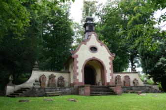
Front of the chapel in Stockhausen

Front view of Stockhausen Castle
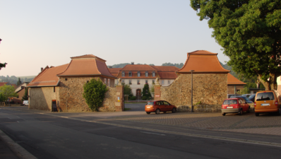
Front of the farm yard


Natural monuments

- Geotope Landenhäuser Stein - This 469 m high ridge is located 1.5 km northeast of Stockhausen. It is designed as a clear edge of the terrain, from which up to 7 m high cliffs of dark gray, fine-grain alkali basalt protrude. The geotope - located in the middle of the forest - can be reached from the village on well-developed walking paths. The rock forms the erosion remains of a basalt cover, which, coming from the Vogelsberg Oberwald , had poured over the red sandstone, which was geologically older.
- Oak with a chest height of 6.92 m (2015).
Economy and Infrastructure
Local transport
The place has two bus stops: "Stockhausen Ortsmitte" is served by the VGO in the RMV bus lines VB-28, VB-42, VB-53 and the call taxes ALT VB-28 and ALT VB-48.
"Stockhausen Kindergarten" is only served by the school bus route VB-28, which is located directly at the oldest village kindergarten in the former Grand Duchy of Hesse-Darmstadt .
Economic structure
The place holds some medium-sized companies as well as a supermarket branch of Tegut (little shop).
The entire local area has a DSL connection with 16 Mbit and in parts around the town center with up to 250 Mbit via VDSL .
Individual evidence
- ↑ a b c d e Stockhausen, Vogelsbergkreis. Historical local dictionary for Hessen. (As of March 23, 2018). In: Landesgeschichtliches Informationssystem Hessen (LAGIS).
- ↑ Numbers and facts. In: Internet presence. Stadt Herbstein, accessed on March 26, 2018 .
- ^ Time table of Stockhausen. (PDF; 166 KB) In: www.herbstein.de. Stadt Herbstein, accessed October 15, 2017 .
- ↑ Law on the reorganization of the Alsfeld and Lauterbach districts (GVBl. II 330-12) of August 1, 1972 . In: The Hessian Minister of the Interior (ed.): Law and Ordinance Gazette for the State of Hesse . 1972 No. 17 , p. 215 , § 7 ( online at the information system of the Hessian state parliament [PDF; 1,2 MB ]).
- ^ Federal Statistical Office (ed.): Historical municipality directory for the Federal Republic of Germany. Name, border and key number changes in municipalities, counties and administrative districts from May 27, 1970 to December 31, 1982 . W. Kohlhammer GmbH, Stuttgart and Mainz 1983, ISBN 3-17-003263-1 , p. 368 .
- ^ Michael Rademacher: German administrative history from the unification of the empire in 1871 to the reunification in 1990. State of Hesse. (Online material for the dissertation, Osnabrück 2006).
- ↑ Wilhelm von der Nahmer: Handbuch des Rheinischen Particular-Rechts: Development of the territorial and constitutional relations of the German states on both banks of the Rhine: from the first beginning of the French Revolution up to the most recent times . tape 3 . Sauerländer, Frankfurt am Main 1832, OCLC 165696316 , p. 23 ( online at google books ).
- ↑ Latest countries and ethnology. A geographical reader for all stands. Kur-Hessen, Hessen-Darmstadt and the free cities. tape 22 . Weimar 1821, p. 425 ( online at Google Books ).
- ↑ Arthur Benno Schmidt : The historical foundations of civil law in the Grand Duchy of Hesse . Curt von Münchow, Giessen 1893, p. 29, note 92 and p. 103, note 14.
- ^ Ordinance on the implementation of the German Courts Constitution Act and the Introductory Act to the Courts Constitution Act of May 14, 1879 . In: Grand Duke of Hesse and the Rhine (ed.): Grand Ducal Hessian Government Gazette. 1879 no. 15 , p. 197–211 ( online at the information system of the Hessian state parliament [PDF; 17.8 MB ]).
- ↑ Local Advisory Boards. In: www.herbstein.de. Stadt Herbstein, accessed October 29, 2016 .
- ^ Entry in the directory of monumental oaks . Retrieved January 10, 2017
- ↑ a b RMV timetable information (must be entered manually). Retrieved October 30, 2016 .
- ↑ tegut ... Markt Stockhausen - opening times and address. In: Market. August 29, 2016. Retrieved October 29, 2016 .
literature
- Stockhausen story (s) by Hans-Heinz Link
- History of the desert (Gertrudt Mackenthum Die Wüstungen des Altkreis Lauterbach 1948)
- Festschrift for the 150th anniversary of the kindergarten and re-inauguration on October 6, 1991
- Festschriften Stockhäuser associations
- Commemorative publication of the Stockhausen savings and loan fund
- Erco von Dietze: Directory of the archive holdings of the Protestant parishes of Stockhausen and Rixfeld with the subsidiary village of Schadges 1568–1950. Finding aid. 1985
- Literature about Stockhausen in the Hessian Bibliography
Web links
- Stockhausen district in the website of the city of Herbstein.
- Stockhausen, Vogelsbergkreis. Historical local dictionary for Hessen. In: Landesgeschichtliches Informationssystem Hessen (LAGIS).
Altenschlirf | Herbstein | Lance Grove | Rixfeld | Schadges | Bad ways | Steinfurt | Stockhausen