Tagus
| Tagus / Tejo | ||
| Data | ||
| location | Spain , Portugal | |
| River system | Tagus | |
| source |
Fuente García 40 ° 19 ′ 15 ″ N , 1 ° 41 ′ 50 ″ W. |
|
| Source height | approx. 1627 msnm | |
| muzzle | in Lisbon in the Atlantic Coordinates: 38 ° 40 ′ 13 ″ N , 9 ° 17 ′ 16 ″ W 38 ° 40 ′ 13 ″ N , 9 ° 17 ′ 16 ″ W |
|
| Mouth height | 0 msnm | |
| Height difference | approx. 1627 m | |
| Bottom slope | approx. 1.6 ‰ | |
| length | 1007 km | |
| Catchment area | 80,600 km² | |
| Left tributaries | Guadiela , Algodor , Ibor , Almonte , Salor | |
| Right tributaries | Alberche , Alagón , Erges , Jarama , Guadarrama , Ocreza , Pônsul , Tiétar , Trancão , Zêzere | |
| Big cities | Lisbon | |
| Medium-sized cities | Aranjuez , Toledo , Talavera de la Reina , Santarém | |
| Residents in the catchment area | approx. 9,500,000 | |
|
Tajo near Toledo, Spain |
||
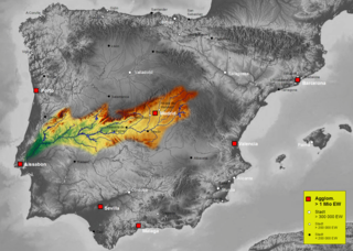
The Tajo ( span. ) And Tagus ( port. ; Ancient name Tagus ) flows in an east-west direction by Spain and Portugal and has about 1007 km the longest river on the Iberian Peninsula .


course
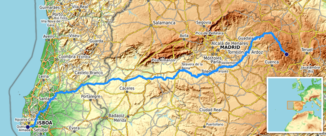
The Tagus rises at the source of the Fuente García in the Montes Universales mountains near the town of Frías de Albarracín ( Province of Teruel ) at an altitude of about 1600 m. It flows first in a north-west direction, then in a south-west and west direction - through the landscape of the Alcarria and around 40 km south of Madrid - through the Spanish cities of Aranjuez , Toledo , Talavera de la Reina and Alcántara as well as through the Portuguese city of Santarém . After about 816 kilometers of river, the Tagus forms the border between Spain and Portugal over a length of about 48 km . It then flows through Portugal for another 145 km and finally flows into the Atlantic at Lisbon .
Catchment area
The catchment area of the Tagus covers a total of approx. 80,600 km², of which 69.2% (55,810 km²) are in the Spanish regions of Aragon , Castile-La Mancha , Madrid and Extremadura and 30.8% in Portugal (24,790 km²). In 2005, around 6.1 million people lived in the Spanish part, and almost 3.5 million in the Portuguese part. On the Iberian Peninsula, only the Duero with 97,290 km² and the Ebro with 85,362 km² have larger catchment areas.
Important tributaries
|
|
There is a canal and an aqueduct between the Rio Tajo and the Río Segura , the Tajo-Segura Canal .
Buildings and sights
bridges
The largest bridge over the river is the Vasco da Gama Bridge ( Ponte Vasco da Gama ) with a total length of 17.2 km. It is the longest bridge in Europe. The Roman Puente de Alcántara and the medieval Puente de San Martín in Toledo are much older . Other Tajo bridges are the Spanish Puente de Alconétar and, in Portugal, the Ponte D. Luís I and Ponte Salgueiro Maia near Santarém and the Ponte da Lezíria and Ponte 25 de Abril . In Lisbon, a third Tagus crossing is to be built between the Vasco da Gama Bridge and the April 25th Bridge .
Attractions
The cities of Toledo and Lisbon on the Tagus and Tejo are among the most important sights of the Iberian Peninsula and all of Europe , but the cities of Aranjuez and Talavera de la Reina also deserve attention.
Power plants and reservoirs
The Tagus has a large number of weirs, dams and reservoirs in its course. The first weirs are in its upper reaches a few kilometers east of Trillo . The major power plants and their reservoirs are (listed downstream):
| power plant | operator | Max. Power (MW) | Reservoir | Surface (km²) | Volume (million m³) |
|---|---|---|---|---|---|
| Entrepeñas | 782 | Entrepeñas | 32.13 | 835 | |
| Bolarque | 15th | Bolarque | 5.1 | 31 | |
| Almoguera | 2 | Almoguera | |||
| Azutan | Azutan | ||||
| Valdecañas | 249 | Valdecañas | |||
| Torrejón-Tagus | Torrejón-Tagus | ||||
| Alcantara | Iberdrola | 915 | Alcantara | 104 | 3,162 |
| Cedillo | Cedillo | ||||
| Fratel | EDP | 130 | Fratel | 10 | 92.5 |
| Belver | EDP | 80.7 | Belver | 2.86 | 12.5 |
The Tagus has no significance as an inland waterway. Ship or ferry traffic only takes place in the area of the mouth of Lisbon.
history
The river was named Tagus by the Romans . Historically significant were the armed conflicts that began in 218 BC. During the Second Punic War on the banks of the Tagus between Hannibal and the Carpetans .
In Portugal, the area south of the Tagus is called " Alentejo "; it is one of the poorest regions in Western Europe.
On September 3, 2018, wreckage of a sunken Nao ship from the period 1575-1625 with pepper and Chinese porcelain from that time on board was discovered in the mouth of the Tagus at a depth of 12 m .
See also
Web links
- Official website of the Confederación Hidrográfica del Tajo (Spanish)
- Tajo Photos + info (English)
Individual evidence
- ↑ Wreck of the Indian fleet discovered near Lisbon orf.at, 23 September 2018, accessed 23 September 2018./


