
Toplița, Hunedoara: Difference between revisions
Content deleted Content added
Adding geodata: {{coord missing|Romania}} |
location |
||
| (37 intermediate revisions by 20 users not shown) | |||
| Line 1: | Line 1: | ||
{{Infobox Romanian subdivision |
|||
'''Topliţa''' is a [[Commune in Romania|commune]] in [[Hunedoara County]], [[Romania]]. |
|||
|type = commune |
|||
|county = Hunedoara |
|||
|name = Toplița |
|||
|image_flag = |
|||
|image_shield = ROU HD Toplita CoA.jpg |
|||
|image_skyline = Valari.latura nordica+.jpg |
|||
|image_caption = Wooden church in Vălari |
|||
|image_location = |
|||
|image_map = Toplita jud Hunedoara.png |
|||
|map_caption = Location in Hunedoara County |
|||
|leader_name = Nicolae Cerișer |
|||
|leader_party = PNL |
|||
|leader_term = 2020–2024 |
|||
|coordinates = {{coord|45|41|N|22|47|E|source:kolossus-ptwiki|display=it}} |
|||
|elevation = 372 |
|||
|elevation_min = |
|||
|elevation_max = |
|||
|area_total = 50.75 |
|||
|area_footnotes = |
|||
|population_as_of = |
|||
|population_total = auto |
|||
|population_footnotes = |
|||
|postal_code = 337480 |
|||
|area_code = (+40) 02 54 |
|||
|website = {{URL|https://toplita-hunedoara.ro/}} |
|||
}} |
|||
'''Toplița''' ({{lang-hu|Királybányatoplica}}) is a [[Commune in Romania|commune]] in [[Hunedoara County]], [[Transylvania]], [[Romania]]. It is composed of eight villages: Curpenii Silvașului, Dăbâca (''Doboka''), Dealu Mic (''Párosza''), Goleș (''Golles''), Hășdău (''Hosdó''), Mosoru (''Moszor''), Toplița, and Vălari (''Valár''). |
|||
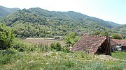
The commune is located in the central-west part of the county, {{cvt|18|km}} southwest of [[Hunedoara]], at the foot of the [[Poiana Ruscă Mountains]]. It lies on the banks of the [[Cerna (Mureș)|Cerna River]] and its tributary, the [[Bunila (river)|Bunila]]. |
|||
| ⚫ | |||
==References== |
|||
{{coord missing|Romania}} |
|||
{{Reflist}} |
|||
{{Gallery |
|||
|File:Biroul turistic in Toplita.jpg|Tourism office in Toplița |
|||
|File:RO HD Hășdău.JPG|Hășdău |
|||
}} |
|||
{{Hunedoara County}} |
|||
{{DEFAULTSORT:Toplita, Hunedoara}} |
|||
[[Category:Communes in Hunedoara County]] |
[[Category:Communes in Hunedoara County]] |
||
[[Category:Localities in Transylvania]] |
|||
| ⚫ | |||
Latest revision as of 13:26, 15 November 2023
Toplița | |
|---|---|
 Wooden church in Vălari | |
 Coat of arms | |
 Location in Hunedoara County | |
 Toplița Location in Romania | |
| Coordinates: 45°41′N 22°47′E / 45.683°N 22.783°E | |
| Country | Romania |
| County | Hunedoara |
| Government | |
| • Mayor (2020–2024) | Nicolae Cerișer (PNL) |
| Area | 50.75 km2 (19.59 sq mi) |
| Elevation | 372 m (1,220 ft) |
| Population (2021-12-01)[1] | 624 |
| • Density | 12/km2 (32/sq mi) |
| Time zone | EET/EEST (UTC+2/+3) |
| Postal code | 337480 |
| Area code | (+40) 02 54 |
| Vehicle reg. | HD |
| Website | toplita-hunedoara |
Toplița (Hungarian: Királybányatoplica) is a commune in Hunedoara County, Transylvania, Romania. It is composed of eight villages: Curpenii Silvașului, Dăbâca (Doboka), Dealu Mic (Párosza), Goleș (Golles), Hășdău (Hosdó), Mosoru (Moszor), Toplița, and Vălari (Valár).
The commune is located in the central-west part of the county, 18 km (11 mi) southwest of Hunedoara, at the foot of the Poiana Ruscă Mountains. It lies on the banks of the Cerna River and its tributary, the Bunila.
References[edit]
-
 Tourism office in Toplița
 -
 Hășdău


This Hunedoara County location article is a stub. You can help Wikipedia by expanding it. |