Autocesta A3
| Autocesta A3 in Croatia | ||||||||||||||||||||||||||||||||||||||||||||||||||||||||||||||||||||||||||||||||||||||||||||||||||||||||||||||||||||||||||||||||||||||||||||||||||||||||||||||||||||||

|
||||||||||||||||||||||||||||||||||||||||||||||||||||||||||||||||||||||||||||||||||||||||||||||||||||||||||||||||||||||||||||||||||||||||||||||||||||||||||||||||||||||
| |
||||||||||||||||||||||||||||||||||||||||||||||||||||||||||||||||||||||||||||||||||||||||||||||||||||||||||||||||||||||||||||||||||||||||||||||||||||||||||||||||||||||
| map | ||||||||||||||||||||||||||||||||||||||||||||||||||||||||||||||||||||||||||||||||||||||||||||||||||||||||||||||||||||||||||||||||||||||||||||||||||||||||||||||||||||||
| Basic data | ||||||||||||||||||||||||||||||||||||||||||||||||||||||||||||||||||||||||||||||||||||||||||||||||||||||||||||||||||||||||||||||||||||||||||||||||||||||||||||||||||||||
| Operator: |
|
|||||||||||||||||||||||||||||||||||||||||||||||||||||||||||||||||||||||||||||||||||||||||||||||||||||||||||||||||||||||||||||||||||||||||||||||||||||||||||||||||||||
| Overall length: | 306.4 km | |||||||||||||||||||||||||||||||||||||||||||||||||||||||||||||||||||||||||||||||||||||||||||||||||||||||||||||||||||||||||||||||||||||||||||||||||||||||||||||||||||||
|
County : |
||||||||||||||||||||||||||||||||||||||||||||||||||||||||||||||||||||||||||||||||||||||||||||||||||||||||||||||||||||||||||||||||||||||||||||||||||||||||||||||||||||||
|
Course of the road
|
||||||||||||||||||||||||||||||||||||||||||||||||||||||||||||||||||||||||||||||||||||||||||||||||||||||||||||||||||||||||||||||||||||||||||||||||||||||||||||||||||||||
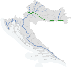
The Autocesta A3 ( Croatian for 'A3 motorway'), also called Posavska autocesta , is the second longest motorway in Croatia and the longest in a west-east direction. It runs on the Sava plain from Bregana on the Slovenian border via Zagreb to Lipovac on the Serbian border , making it the only fully completed transit highway in Croatia at the moment . The motorway is part of the trans-European TEN corridor 10 . It is owned by the state highway company Hrvatske autoceste doo (HAC) . A toll is levied except for the Zagreb southern bypass .
Location in the motorway network
|
||||||||||||||||||||||||
history

During the Yugoslav period , this route was part of the Autoput Bratstvo i jedinstvo and was numbered 1. As in Slovenia , another motorway was given this number after the break-up of Yugoslavia. At the time of Yugoslavia, the motorway was also known as the “motorway of unity and brotherhood”.
Until the breakup of Yugoslavia, the route was considered the most important transit route between Western Europe and Turkey . During the expansion, historical objects were found along the route in eastern Slavonia , which delayed the final completion for a short time.
The cost is estimated at 7 billion kuna.
Trivia
Before the break-up of Yugoslavia, the signs along this highway pointed east to Belgrade . During the War of Independence , Belgrade was replaced by Lipovac on all signposts , which often led to confusion among motorists, as the otherwise little important border town of Lipovac on less detailed road maps and the like. U. is not shown. Today Slavonski Brod , Županja or Osijek (junction via A5 ) and, east of Slavonski Brod, Belgrade is used more and more as directional information .
Open to traffic
| Section | length | release |
| start of building | - | 1977 |
| Jankomir - Lučko | 5.85 km | 1979 |
| Ivanja Reka - Lipovljani | 76.52 km | 1980 |
| Lučko - Ivanja Reka | 22.15 km | 1981 |
| Lipovljani - Okučani | 35.82 km | 1985 |
| Okučani - Prvča | 7.50 km | 1986 |
| Prvča - Brodski Stupnik | 40.56 km | 1988 |
| Brodski Stupnik - Slavonski Brod-zapad | 8.80 km | 1989 |
| Slavonski Brod-zapad - Slavonski Brod-istok | 11.40 km | 1991 |
| Slavonski Brod-istok - Oprisavci | 10.90 km | 1996 |
| Oprisavci - Velika Kopanica | 16.9 km | 1999 |
| Bregana - Jankomir | 13.67 km | 2000 |
| Velika Kopanica - Županja | 25.95 km | 2003 |
| Županja - Lipovac | 29.43 km | 2006 |
| Lipovac - limit | 0.99 km | 2006 |
| total | 306.44 km | 2006 |
References
See also
Web links
- Croatian Motorway Company
- Brochure A3 motorway Bregana - Zagreb - Lipovac (English) ( Memento of September 27, 2007 in the Internet Archive ) (PDF file; 1.64 MB)
- Motorways - Exit Lists (A3 (Croatia))
- Croatian car club
Individual evidence
- ↑ Archive link ( Memento of the original from September 24, 2011 in the Internet Archive ) Info: The archive link was automatically inserted and not yet checked. Please check the original and archive link according to the instructions and then remove this notice.
- ↑ http://www.hrvatskiproizvod.com/vijest.php?broj=634 ( Page no longer available , search in web archives ) Info: The link was automatically marked as defective. Please check the link according to the instructions and then remove this notice.
