Agia Varvara (Attica)
|
Municipality of Agia Varvara Δήμος Αγίας Βαρβάρας (Αγία Βαρβάρα) |
||
|---|---|---|
|
|
||
| Basic data | ||
| State : |
|
|
| Region : | Attica | |
| Regional District : | Athens West | |
| Geographic coordinates : | 38 ° 0 ′ N , 23 ° 39 ′ E | |
| Area : | 2.4 km² | |
| Residents : | 26,550 (2011) | |
| Population density : | 11,062.5 inhabitants / km² | |
| Community logo: | ||
| Seat: | Agia Varvara | |
| LAU-1 code no .: | 4702 | |
| Districts : | no | |
| Local self-government : | no | |
| Website: | agiavarvara.gr | |
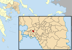
| Location in the Attica region | ||
Agia Varvara ( Greek Αγία Βαρβάρα ( f. Sg. ), Dt. Saint Barbara ) is one of the suburbs of the Greek capital Athens .
The place is located in the Athens-West regional district , four kilometers west of the center of Athens at the foot of Mount Egaleo .
The local Maria Mine is a hydrowoodwardite discovery.
Individual evidence
- ↑ Results of the 2011 census at the National Statistical Service of Greece (ΕΛ.ΣΤΑΤ) ( Memento from June 27, 2015 in the Internet Archive ) (Excel document, 2.6 MB)


