
Petroupoli
|
Petroupoli municipality Δήμος Πετρουπόλεως (Πετρούπολη) |
|||
|---|---|---|---|
|
|||
| Basic data | |||
| State : |
|
||
| Region : | Attica | ||
| Regional District : | Athens West | ||
| Geographic coordinates : | 38 ° 2 ′ N , 23 ° 41 ′ E | ||
| Area : | 6.597 km² | ||
| Residents : | 58,979 (2011) | ||
| Population density : | 8,940.3 inhabitants / km² | ||
| Post Code: | 13231 | ||
| Prefix: | (+30) 210 | ||
| Community logo: |
|
||
| Seat: | Petroupoli | ||
| LAU-1 code no .: | 4706 | ||
| Districts : | no | ||
| Local self-government : |
no |
||
| Website: | www.petroupoli.gov.gr | ||
| Location in the Attica region | |||
 |
|||

Petroupoli ( Greek Πετρούπολη ( f. Sg. )) Is a northwestern suburb of the Greek capital Athens and a municipality with almost 60,000 inhabitants (according to the municipality actually around 80,000) in the Athens-West regional district of the Attica region .
geography
Petroupoli extends at an average height of 140 m on the northwestern edge of the Athens basin at the foot of the Egaleo mountain range . The distance to the center of Athens is around six kilometers. In the municipality, the peak of Pikilo or Zacharitsa ( 465 m ) is the highest point. Its rocky landscape runs the length of the parish on the northwest side and is covered with bushes and low trees. The street grid is regularly laid out at right angles; the streets of the municipality run in a south-west-north-east and north-west-south-east direction, the terrain drops to the south-east to 80 m above sea level.
Neighboring communities beyond the Egaleo are Aspropyrgos to the west and Fyli to the northwest . The municipality of Chaidari adjoins it to the southwest ; in the south and east the urban space flows directly into the area of the municipalities of Peristeri and Ilio .
Petroupoli is divided into four districts with 10 residential areas:
- Agia Triada (Αγία Τριάδα)
- Agios Dimitrios (Άγιος Δημήτριος)
- Ano Petroupoli (Άνω Πετρούπολη)
- Kato Petroupoli (Κάτω Πετρούπολη)
- Kipoupoli (Κηπούπολη)
- Michelis (Μιχελής)
- Nisaki (Νησάκι)
- Panorama (Πανόραμα)
- Palatiani (Παλατιανή)
- Pefka Verdi (Πεύκα Βέρδη)
Petroupoli in the right background at the foot of the Pikilo

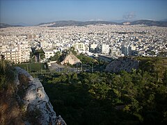
View towards the center of Athens

Central square in Agios Dimitrios

The main street 25is Martiou


history
There are two theories about the origin of the city name. According to the first, Petroupoli is named after the Greek word for 'stone' or 'rock' (petra), as the ground of the area is rocky and there were some quarries on Egaleo in the past. The more common, however, is that the city was named after Petros A. Giannaros, the founder of the Athens newspaper Esperini, whose son and successor Alexandros built the area. Petroupoli is also the common name for Saint Petersburg in Greek .
In the 19th century the area consisted mainly of forest, arable land and pasture land and was used by shepherds from the mountains of central Greece as winter pasture. One of these shepherds, the Arvanite Panousis Verdis, claimed in 1842 to have bought a piece called Klisoura on Mount Pikilo from a Turk in 1815. The north-east of the area of today's municipality belonged to rich Athenian families as large estates.
From 1912 the area belonged to the municipality of Athens, from 1925 to Nea Liosia . The pressure from the refugees as a result of the population exchange between Greece and Turkey in the early 1920s, which caused the population of the Athens Basin to skyrocket, led to an escape from central Athens and the establishment of settlements on the edge of the Athens plain.
The urban development of today's municipality was based on two construction projects from the interwar period.
For example, the heirs of Panousis Verdis's property in the southwest of today's municipality founded a real estate company that planned the construction of a garden city ( Kipoupoli in Greek ) based on the British model on an area of around 1000 hectares . It was built for a 'co- op of the landless' and was initially recognized by two presidential decrees in February 1929 as a 'settlement of the landless' (Greek Sinikismos ton Aktimonon ) and in April of the same year designated as a settlement in Verdi by a development plan .
In the area of what is now the center of the municipality, two large landowners named Noe and Tsouklidis sold an area to the editor of the Esperini newspaper , Alexandros Giannaros. On July 28, 1933, he published a development plan with 165 blocks of flats in his newspaper, for which vouchers could be purchased and paid off in installments of 50 drachmas. This plan corresponds to the current course of the street in the center and in Ano Petroupoli, with today's main street 25is Martiou being recorded as 'Petroupoli-Boulevard' and the crossing 28is Okrovriou as 'Alexandros-Giannaros-Boulevard' according to the publisher. A second plan by the architect Alexandros Metaxas in June 1934 showed 40 more blocks in what is now the Nisaki district . Construction of the first houses began in 1935, the church of St. Dimitrios was built in 1937 and the first elementary school opened in 1938. By the end of 1938, 300 residents had settled in Petroupoli.
1940 Petroupoli with 641 inhabitants was recognized as a settlement in the municipality of Nea Liosia and in 1946 received its independence as a rural municipality (kinotita). It was upgraded to a municipality (dimos) in 1972. The area was mainly developed from the early 1950s to the 1990s. Construction continues, but is limited today.
Limestone was mined in a total of eight quarries in Petroupoli from the late 1940s to the 1980s. In 1953, mining began in the Emos (Αίμος) limestone quarry in Ano Petroupoli, the remains of which characterize the cityscape today.
Population development
| year | population | growth |
|---|---|---|
| 1951 | 1,612 | - |
| 1961 | 8,520 | 6,908 / 428.54% |
| 1971 | 18,634 | 10,114 / 118.71% |
| 1981 | 27.902 | 9,268 / 49.74% |
| 1991 | 38,278 | 10,376 / 27.19% |
| 2001 | 48,327 | 10,049 / 26.25% |
| 2011 | 58,979 | 10,652 / 22.04% |
politics
Petroupoli has a long tradition of mayors from the KKE . For a period of thirty years, the communist Nikolaos Paximadas shaped politics as mayor (1964–1967 and 1975–1994). After his retirement from politics and public life in the city, his party comrade Giorgos Giogos followed him from 1994 to 2002. In 2002 Stefanos Vlachos was elected, supported by Synaspismos and PASOK , and confirmed in office in 2006. When the 2010 Kallikratis program was implemented , the community was not changed. In 2010, Thomas Kotsambas defeated the candidate from the KKE-affiliated list Laiki Syspirosi (about “people's cohesion”) with 55% of the candidates from Synaspismos and PASOK; in May 2014, Vangelis Simos won as one of the youngest mayors of Greece with 53% for the same list.
Culture and sport
The old Emos quarry was converted into an open-air theater with two stages, the Theatro Petras, in the early 1980s . Every summer it is the scene of the International Petras Festival , which hosts concerts and theater performances. Petroupoli also has a cultural center, a music school and a communal cinema.
The site of another quarry now houses the municipal sports facility. The sports club Aris Petroupoli Athens is located in the northeast of the municipality and has , among other things, a football and basketball team.
Infrastructure and traffic
The ASDA ('West Athens Development Association') describes Petroupoli as one of the most developed municipalities in West Athens. However, there are problems such as the lack of green and open spaces within the city, the traffic congestion and the proximity to the Ano Liosia landfill. The city is favored by its location directly on the Pikilo as one of the few natural areas in the area of the capital.
Petroupoli now has 15 kindergartens, 11 elementary, 6 middle and 5 high schools and one vocational school. The infrastructure of shops and restaurants is good, so that Petroupoli is one of the popular nightlife destinations in Athens.
The Greek motorway network is easily accessible from Petroupoli only inner-city streets, the Greek A1 runs about three kilometers southwest. There is no direct connection to the A 65 , which runs a few kilometers from the municipality behind the Egaleo. Local public transport is limited to buses.
literature
- Andreas A. Milionis: Η πόλη της πέτρας ('The City of Stone'), published by the municipality, 2005
- Theodora Potsika: Μελέτη θεσμοθετημένων και υφιστάμενων χρήσεων γης δήμου Πετρούπολη, diploma thesis, Athens 2009, PDF online , Greek.
- Roza Lena: Χωροκοινωνική Εξέλιξη του Δήμου Πετρούπολης. Προβλήματα - Προοπτικές, diploma thesis, Athens 2009, PDF online , Greek.
Individual evidence
- ↑ Results of the 2011 census at the National Statistical Service of Greece (ΕΛ.ΣΤΑΤ) ( Memento from June 27, 2015 in the Internet Archive ) (Excel document, 2.6 MB)
- ↑ Administrative history in the database of the EETAA (Greek Society for Development and Decentralization) ( Memento of the original from October 16, 2013 in the Internet Archive ) Info: The archive link was inserted automatically and has not yet been checked. Please check the original and archive link according to the instructions and then remove this notice.