
Angistri
|
Angistri municipality Δήμος Αγκιστρίου (Αγκίστρι) |
|||
|---|---|---|---|
|
|||
| Basic data | |||
| State : |
|
||
| Region : | Attica | ||
| Regional District : | Islands | ||
| Geographic coordinates : | 37 ° 42 ′ N , 23 ° 21 ′ E | ||
| Area : | 13.367 km² | ||
| Residents : | 1,142 (2011) | ||
| Population density : | 85.4 inhabitants / km² | ||
| Community logo: |
|
||
| Seat: | Megalochori | ||
| LAU-1 code no .: | 5203 | ||
| Districts : | no | ||
| Local self-government : | no | ||
| Website: | www.agistri.gr | ||
| Location in the Attica region | |||
 |
|||

Angistri ( Greek Αγκίστρι ( n. Sg. ), Also Agistri) is a small inhabited Greek island that belongs to the group of Saronic Islands . At the same time it forms an independent municipality in the Attic regional district islands .
Geography and nature

The island is located in the Saronic Gulf about 35 kilometers southwest of Piraeus and six kilometers southwest of the island of Aegina . The Methana peninsula is six kilometers south, the mainland of the Peloponnese 14 kilometers west. Angistri is six kilometers long, up to three kilometers wide and has an area of about 14 km². The interior of the island is forested and hilly and reaches a height of 294 meters.
The flora includes cyclamen , various grasses and thistle species, thyme and capers . Some smaller wild animals live on Angistri, including chukar chickens . The rocky east coast is a breeding ground for swifts . Noteworthy is a population of feral peacocks that were introduced generations ago and have since lived freely around the mountain village of Metochi.
History and present
There are some excavation sites on the island, which was already populated in ancient times and was then called Kekryphaleia ( Κεκρυφάλεια = decorated head ). 459/8 BC Before Kekryphaleia there was a sea battle between Athenians and Peloponnesian ships from which the Athenians emerged victorious. In the 19th century, Angistri was identified with the ancient Pityonesos ( Πιτυόνησος = pine island ). Even in the government papers of King Otto she was called Pityonesus. Today about a thousand inhabitants live permanently on the island; in the summer months the population can easily triple. The inhabitants are spread over the two port towns of Skala and Megalochori (also called Milos by tourists) on the north coast, Metochi a little inland (where there is a small minority of Arvanites ) and the town of Limenaria in the south.
Economy and tourism

Fishing, which dominated just a few decades ago, has become practically insignificant due to overfishing and pollution of the surrounding waters. The agriculture with the cultivation of olives, cereals and fruit as well as the production of retsina - resin becomes less important.
Tourism, on the other hand, is becoming increasingly important. Even if package tourism is still largely unknown, the island is increasingly visited by local tourists, not least because of its proximity to Athens .
The nearest airport is near Athens. From the port of Piraeus there are regular ferry and hydrofoil connections to Angistri and Aigina. An island bus runs between the island towns of Megalochori and Skala during the season (only to Limenaria in the high season). There are also taxis and rental bicycles, and hikers will find some well-tended forest paths (forest paths).
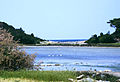
Picture gallery
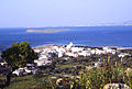
Look at scale
at Limenaria
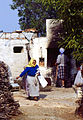
Homestead in Milos

on the coast

Angistri seen from the sea


Web links
Individual evidence
- ↑ Results of the 2011 census at the Greek Statistical Office ELSTAT ( Memento of the original from November 13, 2011 in the Internet Archive ) Info: The archive link has been inserted automatically and has not yet been checked. Please check the original and archive link according to the instructions and then remove this notice.
- ^ Thucydides : History of the Peloponnesian War , 1, 105
- ↑ Diodor : Historical Library , 11, 78
- ↑ Pliny the Elder : Naturalis historia , 4, 19 ( online ; German translation, 1881)
- ^ Government Gazette of the Kingdom of Greece , Nafplio February 4, 1834, No. 4 ( online )