
Markopoulo Mesogeas
|
Municipality of Markopoulo Mesogeas Δήμος Μαρκοπούλου Μεσογαίας (Μαρκόπουλο Μεσογαίας) |
|||
|---|---|---|---|
|
|||
| Basic data | |||
| State : |
|
||
| Region : | Attica | ||
| Regional District : | Eaststatica | ||
| Geographic coordinates : | 37 ° 53 ' N , 23 ° 58' E | ||
| Area : | 81.844 km² | ||
| Residents : | 20,040 (2011) | ||
| Population density : | 244.9 inhabitants / km² | ||
| Community logo: |
|
||
| Seat: | Markopoulo | ||
| LAU-1 code no .: | |||
| Districts : | no | ||
| Local self-government : | no | ||
| Website: | www.markopoulo.gr | ||
| Location in the Attica region | |||
 |
|||

Markopoulo Mesogeas ( Greek Μαρκόπουλο ( n. Sg. ) Μεσογαίας ) is a community in the Attic plateau , the Mesogia . It mainly consists of the two districts of Markopoulo and Porto Rafti , two small towns with just under 10,000 inhabitants each. It is a center of Attic retsina production.
geography

Markopoulo is located in the south of the Mesogia landscape ( ancient Greek Μεσόγαια Mesogaia , Midland '), a plain, the center of which is now occupied by the Athens-Eleftherios Venizelos airport , to which the municipality borders to the south. Mesogia is shielded from the Attic west coast by the Ymittos , which has to be bypassed to the north in order to reach the center of Athens , about 30 km away as the crow flies . The neighboring communities in the plain are (from west to east) Koropi , Peania and Spata-Artemida . To the south is the southern Attic mountainous region, the Merenda ( 613 m ) is the highest point in the municipality. West of the Merenda, the plain narrows into a valley that leads to Kalyvia Thorikou and Kouvaras in the municipality of Saronikos and on to Keratea in the municipality of Lavrio , which borders Markopoulo in the southeast. The municipality flows through the small river Erasinos , which rises on the Ymittos and forms a small wetland near the archaeological site of Brauron and flows into the bay of Vraona of the Petali Gulf. To the south of Brauron, small promontories shield the plain from the sea. The Perati ( 306 m ) rises north of the bay of Porto Rafti. It is framed to the southwest by the Charvati, the Tsourgeli or Mavrinoro ( 404 m ) at Cape Mavroneri forms the southern end. The municipality also includes some small coastal islands and the Agios Nikolaos peninsula in the south of the Rafti Bay.

View over the airport to Vravrona
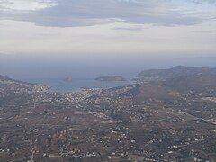
Porto Rafti from the west

The north of the bay of Vravrona

The Erasinos


structure
Although the settlement of the municipality is clearly divided into two large districts (and a few villages), these were never administratively separated; none of the parish's settlements today has local self-government status. The population of the settlements comes from the results of the 2011 census.
- Agia Triada ( Αγία Τριάδα , 218 inhabitants)
- Chamolia ( Χαμολιά , 185 inhabitants)
- Koulidas ( Κουλιδάς , 243 inhabitants)
- Limin Markopoulou ( Λιμήν Μαρκοπούλου 'Port of Markopoulos', this is the official name of Porto Rafti , 9,686 inhabitants)
- Markopoulo ( Μαρκοπούλου , 9,513 inhabitants)
- Vravrona ( Βραυρώνα , 195 inhabitants)
history
Archaeological research during the construction of the equestrian center has proven Stone Age settlement in the municipality. Here, on the northern edge of the Merenda, the Attic Demos Myrrhinus ( ancient Greek altυρρινοῦς ) was also located in classical times , to the north-west of it Angele . Excavations in the bay of Porto Rafti revealed a small settlement from the 3rd millennium BC. BC as well as a large settlement of the Mycenaean culture whose port traded with the entire eastern Mediterranean. Even in historical times, this was the Attic port for trade to the east and Athens' alternative access to the sea, whenever Piraeus was besieged. The cities were Steiria ( Στείρια ) north of the bay and Prasiai ( Πρασίαι ) in the south. Further north on the coast were Philaidai ( Φιλαΐδαι ) and Brauron , on the peninsula in the south of the bay was Koroni , which was briefly in the 3rd century BC. Was developed as a fortress. Some famous people of ancient Attica came from these places, including the Philaids , Phaedrus , Peisistratos and Thrasybulos .
After the heyday of classical Greek culture, these cities fell into small, rural settlements during Roman times, and the decline continued into the Byzantine epoch. Only in the area of Styria has evidence of a larger Byzantine port town been unearthed, which only lost its importance in the 12th century due to the gradual collapse of Byzantine naval rule and increasing pirate attacks on the coast. The castle towers of Vraona and Liada bear witness to the time of the Frankish rule and the Duchy of Athens after the Fourth Crusade in 1204. The years under Catalan rule 1311–1385 are remembered as a reign of terror. The subsequent rule of the Florentine Acciaiuoli family was significant in that it was they who settled Arvanites from Epirus in Mesogia , namely the clan of Giannis Markopoulos, who came to the area around 1420 and founded the village named after the patron of the family. In fact, an Ottoman tax document mentions from 1506 - 1456 Attica fell to the Ottoman Empire - 23 households in the place concerned, most of which families were named Markopoulos.

Terracotta from the late Helladic period
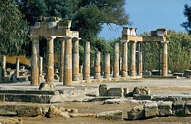
In the Artemis sanctuary of Brauron

Vraona Tower


35 families from Markopoulo have been handed down as participants in the Greek Revolution . After modern Greece was founded, a winegrowers' cooperative was founded in 1831 under the name Kinotiki Epitropi ( Κοινοτική Επιτροπή 'Community Committee'), whose power in the community was equal to that of the official state officials until the 1960s. In 1914 the brand name MARKO was created, under which production is still carried out today.
At the beginning of the 20th century, Porto Rafti was a quiet little fishing port and port for fruit and vegetables from the Cyclades to Athens. After 1923, its importance as a port increased again, for example the tobacco trade from Kavala was carried out exclusively through this port. Its importance for Markopoulos wine production also gradually increased. The preference for Piraeus as the Athens port and the planned but never realized railway connection between Porto Raftis and Athens prevented a major development of the port city.
From 1835 Markopoulo belonged to the municipality of Arafina, from which the municipality of Kekropia was spun off in 1840, in which Markopoulo acted as the municipality seat from 1847. In 1912 it became an independent rural community, from 1915 with the addition of Mesogeas (probably to distinguish it from Markopoulo Oropou in the north of East Africa), and in 1964 it was finally upgraded to a municipal community (dimos) .
Community logo
The community logo was designed by the painter Petros Zoumboulakis and officially adopted in 2004. It unites the tower of Vraona as a landmark with a leaf of the vine for the importance of viticulture and a horse for equestrian sport.
Culture and sights
The Theatro Saras, an open-air theater with 1000 seats, was financed by compensation payments for expropriations for the construction of the new Athens airport and is part of a cultural center that was built on Sara Hill in 2001.
The most important of the archaeological sights is the ruins of the Artemis sanctuary of Brauron with an attached museum. Remains of ancient Steiria can be found in Porto Rafti.
Economy and Infrastructure
The dominant economic branch of agriculture in Markopoulo is viticulture , in addition to the old MARKO cooperative, the major winemaker Greek Wine Cellars D. Kourtakis is particularly important here, who founded his first winery in Markopoulo in 1905, moved his company headquarters to the city in 1972 and, among other things, to the well-known Retsina producers.
Two competition venues were built in Markopoulo for the 2004 Olympic Games : The Markopoulo Equestrian Center replaced the previous Athens Hippodrome in Paleo Faliro and is still used for competitions. The Markopoulo Olympic Shooting Center, where the sport shooting competitions were held, is still used by the Greek police.
Thanks to its proximity to Athens Airport, the municipality is now well connected in terms of transport. The city is connected to the motorway network via the Greek A 6 . The railway line built in 1882 to connect the metal mines in Lavrio to Athens connected Markopoulo with the railway network, but was closed in 1957. Plans to continue line 3 of the Athens metro , which currently runs to Koropi and the airport, are to be expanded to Lavrio in the medium term and would revive the old route.
Web links
Individual evidence
- ↑ a b Results of the 2011 census at the National Statistical Service of Greece (ΕΛ.ΣΤΑΤ) ( Memento from June 27, 2015 in the Internet Archive ) (Excel document, 2.6 MB)
- ^ William Smith: Dictionary of Greek and Roman Geography, London 1854 ( entry on Attika online )
- ↑ Administrative history of the database of the EETAA (Greek Society for Development and Decentralization) ( Memento of the original from October 16, 2013 in the Internet Archive ) Info: The archive link was inserted automatically and has not yet been checked. Please check the original and archive link according to the instructions and then remove this notice.
- ↑ Description on the website of the municipality ( Memento of the original from May 25, 2014 in the Internet Archive ) Info: The archive link was inserted automatically and has not yet been checked. Please check the original and archive link according to the instructions and then remove this notice. (Greek)
- ↑ Company history on the company's website