Albeck (Carinthia)
|
Albeck
|
||
|---|---|---|
| coat of arms | Austria map | |
|
|
||
| Basic data | ||
| Country: | Austria | |
| State : | Carinthia | |
| Political District : | Feldkirchen | |
| License plate : | FE | |
| Main town : | Sirnitz | |
| Surface: | 99.48 km² | |
| Coordinates : | 46 ° 51 ′ N , 13 ° 59 ′ E | |
| Height : | 837 m above sea level A. | |
| Residents : | 983 (January 1, 2020) | |
| Postcodes : | 9571, 9345 | |
| Area code : | 04279 | |
| Community code : | 2 10 01 | |
| NUTS region | AT212 | |
| Address of the municipal administration: |
Sirnitz 1 9571 Albeck |
|
| Website: | ||
| politics | ||
| Mayoress : | Anna Zarre ( Albeck People's Party ) | |
|
Municipal Council : ( 2015 ) (15 members) |
||
| Location of Albeck in the Feldkirchen district | ||
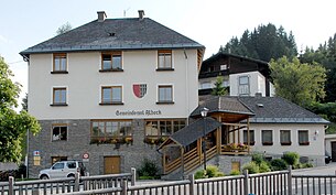
 Municipal office in Sirnitz |
||
| Source: Municipal data from Statistics Austria | ||
Albeck is a municipality with 983 inhabitants (as of January 1, 2020) in the Feldkirchen district in Carinthia .
geography
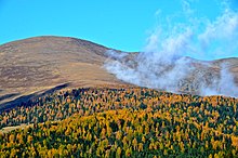
The core area of the municipality of Albeck is located in the Sirnitzbachtal, a side valley of the Gurktal in the Gurktal Alps , east to south-east of the Nockberge . The municipality is located between 790 and 2341 m above sea level (board height). The main town of the community is Sirnitz.
Nature reserve (NSG) "Gurkursprung"
Together with the municipality of Reichenau, Albeck shares the 1,507.1 hectare nature reserve around the Gurkursprung and thus represents the fourth largest nature reserve in Carinthia. In Albeck it is the northwesternmost tip of the municipality, bounded in the north by Kalteben and in the west by the ridge from the Lattersteighöhe over the Bretthöhe and the Torer to the Großer Speikkofel. Neuwirtalm and Michelealm border the area around Gurksee and Torersee in the southeast, including the Schafferalm.
The area is only criss-crossed or framed by hiking trails such as the Lattersteig (No. 156) and the other marked trails with the numbers 109, 153, 155 and 157.
Two small glacial cirque lakes form the origin of the Gurk in the central area of the Gurktal Alps . The Gurksee and Torersee are the heart of the nature reserve . The two high mountain lakes and their surroundings are characterized by their naturalness and their natural beauty. The Mornell Ringed Plover is a specialty . This rare bird finds ideal breeding grounds in the tundra-like landscape.
Community structure
Albeck is divided into the four cadastral communities Albeck, Großreichenau, St. Leonhard and Sirnitz , which comprise a total of 32 localities (population in brackets as of January 1, 2020):
| KG Albeck | KG Großreichenau | KG St. Leonhard | KG Sirnitz |
|---|---|---|---|
| Albeck upper shady side (23) | Hochrindl (44) | Benesirnitz (80) | Egarn (15) |
| Albeck lower shady side (20) | Hochrindl -Alpl (21) | Grillenberg (72) | Frankenberg (27) |
| Lessnitz (4) | Hochrindl cone (54) | Hofern (42) | Kalsberg (48) |
| Neualbeck (9) | Hochrindl -Tatermann (18) | Holzern (1) | Oberdörfl (29) |
| Kruckenalm (0) | Kogl (13) | Obereggen (4) | |
| Lamb (12) | Sirnitz-Schattseite (38) | Sirnitz (291) | |
| Sirnitz-Sonnseite (7) | Pointed meadows (21) | ||
| Sirnitz-Winkl (16) | Untereggen (13) | ||
| St. Ruprecht (20) | Wippa (8) | ||
| Seebachern (0) | |||
| Stron (17) | |||
| Unterdörfl (16) | |||
| Weitental (0) |
Neighboring communities
| Stadl-Predlitz | German handles | |
| Reichenau |

|
Weitensfeld in the Gurktal |
| Gnesau | Steuerberg |
history
Settlement of the municipality should go back to the 10th century. Sirnitz was first mentioned in 1157 (as Sironitz ), Albeck Castle in 1155. Lord of the castle Rudolf von Albeck bequeathed the castle to the Gurk Church , as his son was bishop there. The church property is still very extensive today. The castle fell into disrepair at the end of the 17th century, the stones were used at the beginning of the 18th century to build Neu-Albeck Castle , which from then on served as the official residence of the bishop's keepers. In 1850 the nursing court was closed and the community of Albeck was established.
Mining was occasionally carried out in the 18th century in what is now the municipality. In 1731, the bishop of Gurk had gold and silver mined on the Lattersteig in the Albeck district court, with what success is not known. In 1738, the mountain sovereignty of Salzburg was again restricted when the archbishop's jurisdiction in the city and in the keep of Friesach was denied by a decree of the court chamber of June 11th.
coat of arms
The blazon of the Albeck municipal coat of arms reads:
Declaration of coat of arms: The coat of arms, which was awarded to the municipality on August 8, 1960, refers to the Albeck Castle. No coat of arms is documented from the oldest owners documented between 1155 and 1191, the noble free von Albeck, so that one fell back on the coat of arms of the knights or later lords of Albeck who held the castle as a fief of the Gurk diocese. The oldest surviving seal is that of Otto von Albeck on a document dated May 23, 1260. The rear part of the coat of arms shows heraldic feh (the (belly) fur of the Russian gray squirrel ).
The municipality flag is red-white-black with an incorporated coat of arms.
Community partnerships
Albeck is in partnership with:
-
 Langenau in Baden-Wuerttemberg , Germany
 -
 Fiume Veneto in the Friuli Venezia Giulia region of Italy
Population development
According to the 2001 census, Albeck had 1118 inhabitants, 96.7% of whom were Austrian citizens. 82.2% of the population confessed to the Roman Catholic and 12.3% to the Protestant Church, 3.9% were without religious beliefs.
politics
The municipal council has 15 members.
- With the municipal council and mayoral elections in Carinthia in 2003, the municipal council had the following distribution: 6 ÖVP, 5 FPÖ, and 4 SPÖ.
- With the municipal council and mayoral elections in Carinthia in 2009 , the municipal council had the following distribution: 7 BZÖ, 5 ÖVP, 2 SPÖ, and 1 FPÖ.
- With the municipal council and mayoral elections in Carinthia in 2015 , the municipal council has the following distribution: 7 FPÖ, 6 ÖVP, and 2 SPÖ.
- mayor
- 1973–1999 Georg Wurmitzer (ÖVP)
- 1999–2009 Alois Mödritscher (ÖVP)
- 2009-2015 Siegfried Unterweger (BZÖ) / (FPK)
- since 2015 Anna Zarre (Albeck People's Party)
Culture and sights
Albeck is known, among other things, for the Albeck Castle , a late baroque estate that had jurisdiction over the entire upper Gurktal until 1848. In the main town of Sirnitz there is a late Gothic parish church with a baroque charnel house and a mortuary.
economy
In the rural community, agriculture and forestry predominate, tourism is slowly gaining in importance. In the absence of local businesses, many residents are out-commuters.
The Gurktalstrasse B 93 runs through Albeck. The Postbus line 5208 provides a connection on weekdays to the district capital Feldkirchen , where the nearest train station is also located.
Clubs and organizations
- SGA Sirnitz (football and ski sections)
- Mixed choir Sirnitz
- Trachtenkapelle Sirnitz
- Hunting horn blower group “Diana” Sirnitz
- Mill Association
- Volunteer firefighter
- Comradeship Association
Personalities
- Martin Hinteregger (* 1992), Austrian national soccer player
- Alois Huber (1929–2007), politician and farmer born in Stron
- Elisabeth Sickl (* 1940 in Vienna) former Austrian politician (FPÖ) and Federal Minister
- Georg Wurmitzer (* 1943) former Austrian politician (ÖVP) and retired regional councilor D.
literature
- Hermann Wiessner: History of Carinthian Mining. I. part. History of Carinthian precious metal mining. (= Archive for patriotic history and topography, Volume 32), Verlag des Geschichtsverein für Kärnten, Klagenfurt 1950, pp. 208f.
Web links
- 21001 - Albeck. Community data, Statistics Austria .
- www.albeck.at Website of the municipality of Albeck
Individual evidence
- ↑ Statistics Austria: Population on January 1st, 2020 by locality (area status on January 1st, 2020) , ( CSV )
- ↑ KLA., Mining Authority. Arch. Exhib. Prot. 1731.
- ↑ KLA., Mining Authority. Arch. Exhib. Prot. 1738.
- ↑ WIESSNER, H. (1950): History of the Carinthian mining industry. I. part. History of Carinthian precious metal mining. - Arch. Fatherland. Business Topogr., 32 .: 208, Klagenfurt.
- ^ Quoted from Wilhelm Deuer: Die Kärntner Gemeindewappen , p. 44. Verlag des Kärntner Landesarchivs, Klagenfurt 2006, ISBN 3-900531-64-1
- ^ Statistics Austria, population census, demographic data. May 15, 2001, accessed March 3, 2019 .


