
Hirschstein
| coat of arms | Germany map | |
|---|---|---|

|
Coordinates: 51 ° 15 ' N , 13 ° 21' E |
|
| Basic data | ||
| State : | Saxony | |
| County : | Meissen | |
| Height : | 137 m above sea level NHN | |
| Area : | 34.57 km 2 | |
| Residents: | 1950 (Dec. 31, 2019) | |
| Population density : | 56 inhabitants per km 2 | |
| Postal code : | 01594 | |
| Primaries : | 035267, partly 035268 | |
| License plate : | MEI, GRH, RG, RIE | |
| Community key : | 14 6 27 070 | |
| Community structure: | 11 districts | |
| Address of the municipal administration: |
Hauptstrasse 7 OT Prausitz 01594 Hirschstein |
|
| Website : | ||
| Mayor : | Conrad Seifert ( CDU ) | |
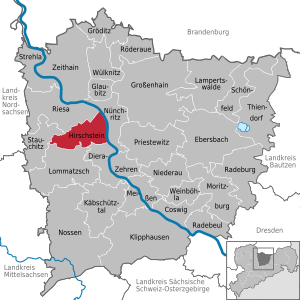
| Location of the municipality of Hirschstein in the district of Meißen | ||
  |
||

Hirschstein is a rural community in the district of Meißen , Saxony , in the catchment area of the sports town of Riesa .
Geography and traffic
The municipality of Hirschstein is located in the central part of the district of Meißen, on the northern edge of the Lommatzscher Pflege and borders the Elbe in the east . The neighboring cities are Meißen (13 km) and Riesa (7 km). The federal road 6 runs between the districts of Mehltheuer and Pahrenz through the community. There are bus connections to Riesa and Meißen. Hirschstein is one of the Elbe wine villages and is also of touristic importance because of the Elbe cycle path that runs along the banks of the Elbe . There is a boat landing stage below the Hirschstein Castle.

Local division
Official districts of the municipality are:
|
coat of arms
The Hirschsteiner coat of arms is an artificial coat of arms that was created after the merger of the previous communities of Hirschstein and Prausitz. It shows the legendary stag, the Kreuzstein near Boritz and a Dutch windmill.
history
Old deer stone
The oldest traces of settlement for the Althirschstein corridor date back to the Stone Age . A Paleolithic flint blade found in a gravel pit is around 100,000 years old and the only find from this cultural epoch in the Riesa region. Today it is in the Riesa local history museum.
Today's place was built in the Middle Ages on the left bank of the Elbe and was first mentioned in 1466 as Alden Herstein . The alley village-like estate settlement has block u. Striped land and comprised a total of about 92 hectares. Together with the neighboring Neuhirschstein, there were 13 gardeners and 6 residents in 1551. Closely the village with the castle Hirschstein whose owner until the 19th century that remained manorial possessed. The administration was incumbent on the Meißen office , from 1875 on the Meißen official administration . A few older farm and cottage properties have been preserved in the village. A cannonball on the gable of one of these buildings reminds of the year 1813, when French soldiers shot at the house from the other side of the Elbe on their retreat from Russia .
Gosa district
The small settlement of Gosa also belongs to Althirschstein. The place mentioned in the 18th century as Gosa or Gasa (1791) consists of only a few buildings and was at times the location of a brick factory and a windmill. The place name is derived from the German word gose = dry, which indicates local conditions. In 1875 there were 79 people living here. Officially, Gosa is already part of Althirschstein in the 19th century and is therefore not an official district of the Hirschstein community.
Neuhirschstein

The remains of three historical fortifications are located on the territory of today's Neuhirschstein district. The oldest is located on the boundary between Alt- and Neuhirschstein and dates back to Slavic times. After the region was taken over by German settlers, another ring wall was built on a cliff above the banks of the Elbe. A third fortification was also built on a rock spur and was the origin of today 's Hirschstein Castle . This castle was first mentioned in documents in 1205. Originally it served as a border fortification to the north and to secure the German rule against the Slavic population, but later developed into the center of a manor and was converted into a residential palace. Friedrich Tuta , Margrave of Meißen, died here in 1291 after a hunt, according to legend, after eating poisoned cherries.
A small settlement for day laborers and farm workers was built around the castle, which was first mentioned in 1551 as Nau Hirstein . This was also where the fiefdom was located , to which the surrounding villages were assigned and which had to pay taxes and labor . Just like the neighboring Althirschstein, Neuhirschstein also belonged to the Meißen district and was assigned to the Meißen district administration in 1875. Ecclesiastically, both villages belonged to Boritz Church (from 1930 parish Boritz-Leutewitz).
From October 7, 1943 to March 4, 1944, before the end of the Second World War, there was a subcamp of the Flossenbürg concentration camp in Meißen-Neuhirschstein , whose 350 prisoners had to do forced labor for the SS at Neuhirschstein Castle. The subcamp had the code name Haus Elbe .
Population development until 1925
| year | Inhabitants of Althirschstein | Inhabitants of Neuhirschstein |
|---|---|---|
| 1551 | 13 gardeners, 6 residents | see Althirschstein |
| 1764 | 12 gardeners, 11 cottagers | 4 possessed men, 9 gardeners, 9 cottagers |
| 1834 | 199 (with manor) | 173 (without manor) |
| 1871 | 200 | 249 |
| 1890 | 240 | 256 |
| 1910 | 228 | 204 |
| 1925 | 254 | 252 |
Incorporation
Alt- and Neuhirschstein kept their independence until 1935 and were then incorporated into Boritz and Bahra. During the Second World War , Hirschstein Castle served as a prison from 1944 to 1945 for King Leopold of Belgium and his family, who were interned here. In the course of an administrative reform in the GDR, Boritz with its district Althirschstein and Bahra with Neuhirschstein were assigned to the newly formed Riesa district in 1952. This went on in 1994 in the Riesa-Großenhain district . In the same year Boritz and Bahra united to form the Hirschstein community. On April 1, 1996, this was incorporated into the community of Mehltheuer and on October 1, 1996 again renamed Hirschstein.
politics
Since the municipal council election on May 25, 2014 , the 14 seats of the municipal council have been distributed among the individual groups as follows:
- CDU : 5 seats
- Mehltheuer “United Village Community” (WVM) voters' association: 3 seats
- For a strong Hirschstein (SGH) community: 3 seats
- Regional farmers' association Elbe / Röder eV (RBV): 3 seats
mayor
Conrad Seifert (CDU) was elected to succeed Christine Gallschütz (CDU) in June 2015.
Culture and sights
- see also: List of cultural monuments in Hirschstein
- Hirschstein Castle
- Castle park with mausoleum and ancient fortifications
- Dutch windmill Pahrenz
- Boritz Farm Museum
- Heyda village church
economy
In the Heyda district, the Sachsen vehicle manufacturer has been producing a replica of the AC Cobra since 2009 .
Associations and initiatives
- Citizens' initiative "Althirschstein landfill" (BIDA)
- GREEN LIGA Hirschstein eV
- Choral society Prausitz 1896 eV
- SV Hirschstein
- DFC Mehltheuer
Regular events
- Easter fountains decorate all districts
- Easter market at Hirschstein Castle
- Concerts on the Kulturboden at Hirschstein Castle
- the annual "Santa Claus awakening" on the day of the open monument with many dealers and activities for children and families
- Lantern parade of the primary school "Franciscus Nagler" Prausitz in autumn
- BIDA clay pit festival in Althirschstein
- Mühlenhoffest and German Milling Day at the windmill in Pahrenz on Pentecost Sunday and Whit Monday
- Street festival Heyda
- Froschfest Pahrenz
literature
- Cornelius Gurlitt : Hirschstein. In: Descriptive representation of the older architectural and art monuments of the Kingdom of Saxony. 41. Issue: Administrative Authority Meißen-Land . CC Meinhold, Dresden 1923, p. 202.
Web links
- Official website of the municipality
- Hirschstein in the Digital Historical Directory of Saxony
- Althirschstein in the Digital Historical Directory of Saxony
- Neuhirschstein in the Digital Historical Directory of Saxony
- Aerial photos
Individual evidence
- ↑ Population of the Free State of Saxony by municipalities on December 31, 2019 ( help on this ).
- ^ Official parts of the municipality of Hirschstein in the Saxony regional register
- ↑ Althirschstein on the website of the Hirschstein community
- ↑ Dietrich Zühlke: Elbtal and Lösshügelland near Meissen , values of our homeland (volume 32), Akademie-Verlag, 1982, p. 50.
- ↑ Gosa in the Digital Historical Directory of Saxony
- ↑ Neuhirschstein on the website of the Hirschstein community
- ^ Website of the Flossenbürg Concentration Camp Memorial Accessed July 6, 2016
- ^ StBA: Changes in the municipalities in Germany, see 1996
- ↑ Results of the 2014 municipal council elections
- ↑ https://www.statistik.sachsen.de/wpr_neu/pkg_s10_bmlr.prc_erg_bm?p_bz_bzid=BM152&p_ebene=GE&p_ort=14627070
Coswig | Diera-Zehren | Ebersbach | Glaubitz | Gröditz | Grossenhain | Hirschstein | Käbschützal | Klipphausen | Lampertswalde | Lommatzsch | Meissen | Moritzburg | Niederau | Nossen | Nünchritz | Priestewitz | Radebeul | Radeburg | Riesa | Röderaue | Schönfeld | Stauchitz | Strehla | Thiendorf | Weinböhla | Wülknitz | Zeithain