
Oud-Heverlee
| Oud-Heverlee | |||
|---|---|---|---|

|

|
||
|
|||
| State : |
|
||
| Region : | Flanders | ||
| Province : | Flemish Brabant | ||
| District : | Lions | ||
| Coordinates : | 50 ° 50 ′ N , 4 ° 40 ′ E | ||
| Area : | 31.14 km² | ||
| Residents: | 11,112 (Jan 1, 2019) | ||
| Population density: | 357 inhabitants per km² | ||
| Post Code: | 3050 (Oud-Heverlee) 3051 (Sint-Joris-Weert) 3052 (Blanden) 3053 (Haasrode) 3054 (Vaalbeek) |
||
| Prefix: | 016 | ||
| Mayor: | Adri Daniëls ( CD&V ) | ||
Local government address : |
Gemeentehuis, Gemeentestraat 2, 3054 Oud-Heverlee |
||
| Website: | www.oud-heverlee.be | ||

Oud-Heverlee is a municipality in the south-eastern part of Dijlelandes in the province of Flemish Brabant in the Kingdom of Belgium . This municipality in Flanders has 11,112 inhabitants (as of January 1, 2019) and is located south of Leuven on the Dutch - French language border. Oud-Heverlee consists of the five sub-municipalities Oud-Heverlee, Blanden, Haasrode, Sint-Joris-Weert and Vaalbeek.
Nature and relaxation
Despite its proximity to Leuven, the community is very green. More than 40% of the municipal area consists of forest, which is distributed over the Meerdaalbos , the Egenhovenbos and the Heverleebos . These forests are considered to be the remains of the coal forest . The "Doode Beemde" nature reserve is also on the territory of the municipality.
Pictures of the place

De Watermolen is an old watermill and inn
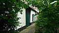
An old farm

Zoete Waters is the name of the recreation area with five ponds in Oud-Heverlee.

Minnebron , a spring in the Heverleebos in Oud-Heverlee


Sons and daughters of the church
- André Delvaux (1926–2002), Belgian director
Web links

Aarschot | Affligem | Aces | Beersel | Begijnendijk | Bekkevoort | Bertem | Bever | Bierbeek | Boortmeerbeek | Boutersem | This | Dilbeek | Drug bos | Galmaarden | Prayer | Glabbeek | Gooik | Grimbergen | Haacht | Hall | Herent | Herne | Hoegaarden | Hoeilaart | Holsbeek | Huldenberg | Kampenhout | Chapel-op-den-Bos | Keerbergen | Kortenaken | Kortenberg | Kraainem | Landing | Lennik | Lions | Liedekerke | Linkebeek | Linter | Londerzeel | Lubbeek | Machelen | Titmouse | Merchtem | Opwijk | Oud-Heverlee | Overijse | Pepingen | Roosdaal | Rotselaar | Scherpenheuvel-Zichem | Sint-Genesius-Rode | Sint-Pieters-Leeuw | Steenok candle | Ternat | Tervuren | Tielt-Winge | Tienen | Tremelo | Vilvoorde | Wemmel | Wezembeek-Oppem | Zaventem | Zemst | Zoutleeuw