Brend (mountain)
| Brend | ||
|---|---|---|
|
View from the Brend to the Vosges |
||
| height | 1149.3 m above sea level NHN | |
| location | near Furtwangen , Schwarzwald-Baar district , Baden-Württemberg ( Germany ) | |
| Mountains | Middle Black Forest | |
| Coordinates | 48 ° 4 '46 " N , 8 ° 9' 26" E | |
|
|
||
| particularities | Brend Tower ( AT ) | |
|
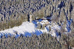
Aerial view of Brend |
||
The Brend is a 1149.3 m above sea level. NHN high mountain in the Middle Black Forest . It is the highest point in the area around the city of Furtwangen and is considered the local mountain .
location
Located in the Schwarzwald-Baar district , the Brend is the second highest elevation after the extensive Rohrhardsberg- Fernberg plateau. Before the district reform in 1973, it was the highest point in the Donaueschingen district .
The southern slope of the Brends lies on the parish of the municipality of Simonswald in the district of Emmendingen . There it is after the Kandel and the Rohrhardsberg -Farnberg-Plateau together with the Rosseck the third highest elevation. In the course of an area swap in 1977, the affiliation of the observation tower and the inn as well as a farm on the north-western slope of Obersimonswald, Emmendingen district, changed to the town of Furtwangen, Schwarzwald-Baar district.
When the visibility is good, the summit offers a beautiful panoramic view of Hochfirst , Feldberg , Belchen , Schauinsland and Kandel. In the south is the Swiss Alpine chain from Säntis in the Appenzell Alps to the "triumvirate" Eiger , Mönch and Jungfrau in the Bernese Oberland , in the northwest the Vosges from Gazon de Faîte to Mont Sainte-Odile and in the east the eaves of the Swabian Alb from the Zollernalb to see the Hegaualb. In addition to the inn and the Brend Tower, there is also a Friends of Nature House on the summit .
Together with the Rohrhardsberg to the north, the Brend forms one of the largest and, at over 1,100 m, the highest plateau in the Black Forest. The plateau is one of the largest natural areas in the state of Baden-Württemberg that is not cut up by roads . The development takes place through a few spur streets. The summit itself and a large barbecue area can be reached by car from Furtwangen or Gütenbach .
Observation tower
The observation tower on the Brend was built in 1905 by the Black Forest Association . The tower itself is round and made of granite blocks. You can climb the 17 meter high tower via a spiral staircase on the outside in the lower half and on the inside in the upper half .
Many railway enthusiasts have the observation tower at home reduced in size, as it serves as a template for a corresponding model.
Sports and leisure opportunities
The European long-distance hiking trail E1 ( North Cape - Sicily ), which here coincides with the Westweg ( Pforzheim - Basel ), leads over the summit . The Brend and its surroundings are a popular winter sports area for cross-country skiing and related winter sports when there is enough snow . The Black Forest Skimarathon (Wäldercup) Schonach - Belchen and the Black Forest Bike Marathon route lead across the Brend.
European watershed
The Brend represents the westernmost and at the same time the highest extra-Alpine point of the European watershed between the Rhine and the Danube . The longest source river of the Danube, the Breg , has its source at the nearby Martinskapelle, which is only around 70 m below . From there, the water takes a 2,888 km route to the southeast to the Black Sea (provided it does not seep away at the Danube sinking point and cross over to the Aachtopf and thus to Lake Constance / Rhine). This means that the source is furthest away from the mouth of the Danube and is one of the two contenders for the title of " Danube source " in the well-known "Danube spring dispute" between Furtwangen and Donaueschingen .
Rivers
The river Elz rises only a few 100 m away and flows northwest into the Rhine in the Taubergießen nature reserve near Lahr . To the west of the Brend, the side streams of the Wilden Gutach, flowing to the Elz, plunge into the Simonswälder Valley, which is around 700 m lower . At the Brend, the different erosion capacities of the Rhenan system (draining to the Rhine) with deep valleys and gorges and the Danubian system (draining to the Danube) with flat high valleys and troughs can be observed by way of example. The Rhine and its tributaries can develop a greater erosion capacity than the Danube because of the shorter distance to the sea and the resulting steeper gradient. At the Brend, the landscapes of the Middle Black Forest, which here belong to the municipality of Simonswald (Emmendingen district), meet with the landscapes of the Upper Black Forest, here belonging to the town of Furtwangen (Schwarzwald-Baar district).
In the immediate vicinity are the sources of the Brigach (the second source river of the Danube) near Brigach and the Gutach near Schönwald (a large tributary of the Kinzig ), known for its Triberg waterfalls . The local tourism administration "Das Ferienland" has connected the four sources with a promising and relatively flat "four source path".
Web links
Individual evidence
- ↑ Map services of the Federal Agency for Nature Conservation ( information )
- ↑ Brendturm Furtwangen on alemannische-seiten.de


