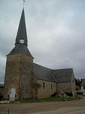
Brette-les-Pins
| Brette-les-Pins | ||
|---|---|---|
|
|
||
| region | Pays de la Loire | |
| Department | Sarthe | |
| Arrondissement | Le Mans | |
| Canton | Changé | |
| Community association | Sud-Est du Pays Manceau | |
| Coordinates | 47 ° 55 ' N , 0 ° 20' E | |
| height | 61-139 m | |
| surface | 14.51 km 2 | |
| Residents | 2,153 (January 1, 2017) | |
| Population density | 148 inhabitants / km 2 | |
| Post Code | 72250 | |
| INSEE code | 72047 | |
| Website | http://www.brettelespins.fr/ | |
 Brette-les-Pins town hall |
||
Brette-les-Pins is a French commune with a population of 2,153 (as at 1st January 2017) in the department of Sarthe in the region Pays de la Loire . Brette-les-Pins is part of the Arrondissement of Le Mans and the Canton of Changé (until 2015: Canton of Écommoy ). Its inhabitants are called Brettois .
geography
Brette-les-Pins is about fifteen kilometers south-southeast of the city center of Le Mans . Brette-les-Pins is surrounded by the neighboring communities Parigné-l'Évêque in the north and east, Saint-Mars-d'Outillé in the south, Teloché in the west and south-west and Ruaudin in the north-west.
The A28 autoroute runs through the municipality .
Population development
| year | 1962 | 1968 | 1975 | 1982 | 1990 | 1999 | 2006 | 2012 |
| Residents | 974 | 1,176 | 1,337 | 1,352 | 1,385 | 1,491 | 1.910 | 2.152 |
Attractions
- Saint-Martin church, built in the 11th century, with alterations in the 13th century
- Coudereau Castle from the middle of the 17th century
- Le Haut-Bois Castle, built at the end of the 15th century
literature
- Le Patrimoine des Communes de la Sarthe. Flohic Editions, Volume 1, Paris 2000, ISBN 2-84234-106-6 , pp. 439-441.
Web links
Commons : Brette-les-Pins - collection of images, videos and audio files

