
Trangé
| Trangé | ||
|---|---|---|
|
||
| region | Pays de la Loire | |
| Department | Sarthe | |
| Arrondissement | Le Mans | |
| Canton | Le Mans 7th | |
| Community association | Le Mans metropolis | |
| Coordinates | 48 ° 2 ′ N , 0 ° 7 ′ E | |
| height | 57-129 m | |
| surface | 11.11 km 2 | |
| Residents | 1,415 (January 1, 2017) | |
| Population density | 127 inhabitants / km 2 | |
| Post Code | 72650 | |
| INSEE code | 72360 | |
| Website | http://www.trange.fr/ | |

Trangé is a French commune with 1,415 inhabitants (as of January 1 2017) in the department of Sarthe in the region Pays de la Loire ; it belongs to the Arrondissement of Le Mans and the canton of Le Mans-7 (until 2015: canton of Le Mans-Nord-Ouest ). The inhabitants are called Trangéens .
geography
Trangé is about six kilometers west-northwest of Le Mans . Trangé is surrounded by the neighboring communities of Aigné in the north, La Milesse in the northeast, La Chapelle-Saint-Aubin in the east, Le Mans in the east and southeast, Rouillon in the south and southeast, Pruillé-le-Chétie in the south, Fay in the southwest and Chaufour -Notre Dame in the west.
Autoroute A11 and Autoroute A81 run through the municipality .
Population development
| 1962 | 1968 | 1975 | 1982 | 1990 | 1999 | 2006 | 2013 | |
|---|---|---|---|---|---|---|---|---|
| 398 | 522 | 583 | 595 | 925 | 1,040 | 1,355 | 1,350 | |
| Source: Cassini and INSEE | ||||||||
Attractions
- Saint-Gervais-et-Saint-Protais church
- La Groirie Castle, Monument historique since 1974
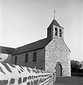
Saint-Gervais-et-Saint-Protais church
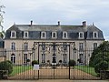
La Groirie Castle


Community partnerships
There is a partnership with the British community of Dunston in Lincolnshire (England).